Country:
 Romania
Region:
City:
Latitude and Longitude:
Time Zone:
Postal Code:
IP information under different IP Channel
ip-api
Country
Region
City
ASN
Time Zone
ISP
Blacklist
Proxy
Latitude
Longitude
Postal
Route
IPinfo
Country
Region
City
ASN
Time Zone
ISP
Blacklist
Proxy
Latitude
Longitude
Postal
Route
MaxMind
Country
Region
City
ASN
Time Zone
ISP
Blacklist
Proxy
Latitude
Longitude
Postal
Route
Luminati
Country
RORegion
if
City
voluntari
ASN
Time Zone
Europe/Bucharest
ISP
Orange Romania S.A.
Latitude
Longitude
Postal
db-ip
Country
Region
City
ASN
Time Zone
ISP
Blacklist
Proxy
Latitude
Longitude
Postal
Route
ipdata
Country
Region
City
ASN
Time Zone
ISP
Blacklist
Proxy
Latitude
Longitude
Postal
Route
Popular places and events near this IP address
1 Decembrie 1918 University of Alba Iulia
Research institution in Romania
Distance: Approx. 4397 meters
Latitude and longitude: 46.069,23.57244
1 Decembrie 1918 University of Alba Iulia is a public higher education and research institution founded in 1991 in Alba Iulia, Romania. It is a state institution, integrated into the national higher education system, which functions based on the Constitution of Romania, the Law of Education, the University Charter, and its own regulations. The name of the university is derived from the date, 1 December 1918, when the Union of Transylvania with Romania was declared, today recognized in Romania as Great Union Day.

Ampoi
River in Alba County, Romania
Distance: Approx. 3949 meters
Latitude and longitude: 46.054,23.597
The Ampoi (Hungarian: Ompoly) is a river in the Apuseni Mountains, Alba County, western Romania. It is a right tributary of the river Mureș. It flows through the town Zlatna, and joins the Mureș near Alba Iulia.

Galda (river)
River in Alba County, Romania
Distance: Approx. 1003 meters
Latitude and longitude: 46.0923,23.6226
The Galda (Hungarian: Gáldi-patak) is a right tributary of the river Mureș in Transylvania, Romania. It discharges into the Mureș in Sântimbru. Its length is 43 km (27 mi) and its basin size is 250 km2 (97 sq mi).
Ciugud
Commune in Alba, Romania
Distance: Approx. 3790 meters
Latitude and longitude: 46.05,23.61666667
Ciugud (Hungarian: Maroscsüged; ‹See Tfd›German: Schenkendorf) is a commune located in the central part of Alba County, Transylvania, Romania. It is composed of six villages: Ciugud, Drâmbar (Drombár), Hăpria (Oláhherepe), Șeușa (Sóspatak), Teleac (Újcsongvaitelep), and Limba (Dumbrava from 1960 to 2004; Lombfalva).

Coronation Cathedral, Alba Iulia
Romanian Orthodox cathedral in Romania
Distance: Approx. 4607 meters
Latitude and longitude: 46.068448,23.569821
The Coronation Cathedral (Romanian: Catedrala Încoronării), dedicated to the Holy Trinity and the Holy Archangels Michael and Gabriel, is a Romanian Orthodox cathedral located at 16 Mihai Viteazul Street, Alba Iulia, Romania. Built soon after and in commemoration of the Union of Transylvania with Romania, it is the seat of the Romanian Orthodox Archdiocese of Alba Iulia.
Zidava
Distance: Approx. 923 meters
Latitude and longitude: 46.0776,23.6338
Zidava was a Dacian fortified town in present-day Alba County, in the Transylvanian region of Romania.

Alba Iulia Fortress
Historic fortress in Alba Iulia, Romania
Distance: Approx. 4545 meters
Latitude and longitude: 46.06751,23.57124
The Alba Carolina Citadel (Romanian: Cetatea Alba Carolina, Hungarian: Gyulafehérvári vár) is a star-shaped fortress located in Alba Iulia, Romania. Its construction commenced on November 4, 1715, during the Habsburg rule in Transylvania, and was completed in 1738. 20,000 serfs were involved in its construction, which is estimated to have cost around 3 million florins.

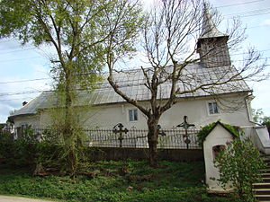
Lipoveni Church
Heritage site in Alba County, Romania
Distance: Approx. 3024 meters
Latitude and longitude: 46.07564,23.58791
The Lipoveni Church is a Romanian Orthodox church located at 17 Mărășești Street, Alba Iulia, Romania. It is dedicated to the Dormition of the Theotokos. The church takes its name from Lipoveni, a neighborhood in the northern part of the city.

Greek Church (Alba Iulia)
Heritage site in Alba County, Romania
Distance: Approx. 3522 meters
Latitude and longitude: 46.07371,23.58203
The Greek Church (Romanian: Biserica Grecească) is a Romanian Orthodox church located at 7 Avram Iancu Street, Alba Iulia, Romania. It is dedicated to the Feast of the Annunciation. The church was built between 1782 and 1794.

Maieri Churches
Heritage site in Alba County, Romania
Distance: Approx. 4209 meters
Latitude and longitude: 46.062068,23.580507
The Maieri Churches are a pair of Romanian Orthodox churches located on Iașilor Street, Alba Iulia, Romania. Each is dedicated to the Holy Trinity.
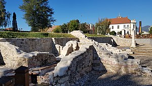
Apulum (conurbation)
Distance: Approx. 4425 meters
Latitude and longitude: 46.0679,23.5727
The twin towns of Apulum were a major urban centre of Roman Dacia, nowadays completely covered by the city of Alba Iulia. They developed in the vicinity of the legionary fortress of Legio XIII Gemina: Colonia Aurelia Apulensis and Colonia Nova Apulensis. The conurbation extended over 140 ha in the 3rd century with an estimated population between 15,000 and 20,000.

Obelisk of Horea, Cloșca, and Crișan
Monument in Alba Iulia, Romania
Distance: Approx. 4196 meters
Latitude and longitude: 46.06722222,23.57638889
The Obelisk of Horea, Cloșca, and Crișan is a historical monument located in Alba Iulia, Alba County, Romania.
Weather in this IP's area
overcast clouds
14 Celsius
14 Celsius
14 Celsius
15 Celsius
1012 hPa
97 %
1012 hPa
986 hPa
10000 meters
1.07 m/s
1.42 m/s
232 degree
100 %
07:29:13
18:58:13