Country:
Region:
City:
Latitude and Longitude:
Time Zone:
Postal Code:
IP information under different IP Channel
ip-api
Country
Region
City
ASN
Time Zone
ISP
Blacklist
Proxy
Latitude
Longitude
Postal
Route
Luminati
Country
Region
b
City
bucharest
ASN
Time Zone
Europe/Bucharest
ISP
Orange Romania S.A.
Latitude
Longitude
Postal
IPinfo
Country
Region
City
ASN
Time Zone
ISP
Blacklist
Proxy
Latitude
Longitude
Postal
Route
db-ip
Country
Region
City
ASN
Time Zone
ISP
Blacklist
Proxy
Latitude
Longitude
Postal
Route
ipdata
Country
Region
City
ASN
Time Zone
ISP
Blacklist
Proxy
Latitude
Longitude
Postal
Route
Popular places and events near this IP address
Voluntari
Town in Ilfov, Romania
Distance: Approx. 1548 meters
Latitude and longitude: 44.4925,26.19138889
Voluntari (Romanian pronunciation: [volunˈtarʲ]) is a town in Ilfov County, Muntenia, Romania. It is located at a distance of 1 km from the northern border of Bucharest (on the DN2 road towards Urziceni) and is thus frequently viewed as a suburb of Bucharest. The population is 47,366 inhabitants according to the 1 December 2021 census, with an ethnic composition, among those for whom data are available, of 94.8% Romanians, 1.3% Romani, 0.9% Chinese, 0.5% Turks, and 2.5% of other ethnic groups.

Dobroești
Commune in Ilfov, Romania
Distance: Approx. 3976 meters
Latitude and longitude: 44.45111111,26.18055556
Dobroești is a commune in the east of Ilfov County, Muntenia, Romania, right off the limits of Bucharest's Sector 2. It is composed of two villages, Dobroești and Fundeni. The name Dobroești is derived from South Slavic/Bulgarian "Dobro" (good) and Romanian suffix -ești.

Colentina, Bucharest
Neighborhood in Bucharest, Romania
Distance: Approx. 2907 meters
Latitude and longitude: 44.46666667,26.15
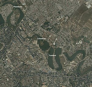
Colentina is a neighbourhood in Bucharest's Sector 2. It is located on the north-east of the city and is named after the nearby Colentina River.
Pipera
Neighborhood in Voluntari, Romania
Distance: Approx. 3547 meters
Latitude and longitude: 44.5,26.13333333
Pipera village is a neighborhood in Voluntari, Ilfov County, at the northern edge of the city of Bucharest, Romania.
Valea Saulei
River in Bucharest, Romania
Distance: Approx. 3404 meters
Latitude and longitude: 44.4759,26.1336
The Valea Saulei is a left tributary of the river Colentina in Romania. It flows into the Colentina in Bucharest. Its length is 6 km (3.7 mi) and its basin size is 50 km2 (19 sq mi).
Doamna Ghica Plaza
Distance: Approx. 4475 meters
Latitude and longitude: 44.45182,26.14532
Doamna Ghica Plaza (Romfelt Plaza) is a large residential building complex located in Bucharest, Romania. The complex is composed of nine buildings with a total surface of 132,000 m2 (1,420,000 sq ft), the tallest tower having 24 floors and a height of 80 metres (260 ft).

Lake Fundeni
Distance: Approx. 4064 meters
Latitude and longitude: 44.451122,26.161194
Lake Fundeni is a man-made lake on the Colentina River in Bucharest, Sector 2. It has a surface of 35 ha (86 acres), length of 2.1 km (1.3 mi), width of 200–800 m, a depth between 1 and 5 meters, and a volume of 800,000 m3 (1,000,000 cu yd). In the middle of the lake there is an island with a surface area of 3.16 ha (7.8 acres).

Fundeni, Bucharest
Distance: Approx. 2982 meters
Latitude and longitude: 44.46074,26.163511
Fundeni is a district in Sector 2 of Bucharest, Romania. It is situated in the northeastern outskirts of the city, on the left bank of the Colentina River, downstream of Plumbuita Monastery, and near the Fundeni Lake that was formed on the river. On its west and north-west are located the Colentina and Andronache neighbourhoods, on its north the town of Voluntari and on its east the commune of Dobroești.
British School of Bucharest
British international school in Romania
Distance: Approx. 4479 meters
Latitude and longitude: 44.5148,26.1337
British School of Bucharest (BSB) is a British international school located at 42 Erou Iancu Nicolae Street, Voluntari, Ilfov County, Romania, in the Bucharest metropolitan area. Established in 2000, the school welcomes more than 600 students each year, aged 2–18. The school serves from Pre-Nursery, up to Year 13.

Popa Nan Church
Heritage site in Bucharest, Romania
Distance: Approx. 2809 meters
Latitude and longitude: 44.464833,26.155667
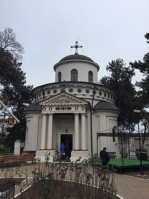
The Popa Nan Church (Romanian: Biserica Popa Nan) is a Romanian Orthodox church located at 47A Popa Nan Street in Bucharest, Romania. It is dedicated to Saints Constantine and Helena. The first small, single-domed church on the site was built in 1719.

Teiul Doamnei Ghica Church
Orthodox church in Bucharest, Romania
Distance: Approx. 4222 meters
Latitude and longitude: 44.4668,26.12838
The Teiul Doamnei Ghica Church (Romanian: Biserica Teiul Doamnei Ghica, lit. “Lady Ghica’s linden tree”) is a Romanian Orthodox church located at 3 Doamna Ghica Street in Bucharest, Romania. It is dedicated to the Feast of the Ascension.

Plumbuita Monastery
Heritage site in Bucharest, Romania
Distance: Approx. 3452 meters
Latitude and longitude: 44.472288,26.135172
The Plumbuita Monastery (Romanian: Mănăstirea Plumbuita) is a Romanian Orthodox monastery located at 58 Plumbuita Street in Bucharest, Romania. Its church is dedicated to Saint John the Baptist.
Weather in this IP's area
clear sky
15 Celsius
14 Celsius
14 Celsius
16 Celsius
1001 hPa
51 %
1001 hPa
991 hPa
10000 meters
3.6 m/s
250 degree
07:18:35
16:43:44
