Country:
 Romania
Region:
City:
Latitude and Longitude:
Time Zone:
Postal Code:
IP information under different IP Channel
ip-api
Country
Region
City
ASN
Time Zone
ISP
Blacklist
Proxy
Latitude
Longitude
Postal
Route
IPinfo
Country
Region
City
ASN
Time Zone
ISP
Blacklist
Proxy
Latitude
Longitude
Postal
Route
MaxMind
Country
Region
City
ASN
Time Zone
ISP
Blacklist
Proxy
Latitude
Longitude
Postal
Route
Luminati
Country
RORegion
if
City
voluntari
ASN
Time Zone
Europe/Bucharest
ISP
Orange Romania S.A.
Latitude
Longitude
Postal
db-ip
Country
Region
City
ASN
Time Zone
ISP
Blacklist
Proxy
Latitude
Longitude
Postal
Route
ipdata
Country
Region
City
ASN
Time Zone
ISP
Blacklist
Proxy
Latitude
Longitude
Postal
Route
Popular places and events near this IP address

Pipera metro station
Bucharest metro station
Distance: Approx. 2288 meters
Latitude and longitude: 44.4806,26.1165
Pipera is a metro station in Bucharest, located in the Pipera district. Opened on 24 October 1987 as part of the M2 extension from Piața Unirii, it is the northern terminus of the line. The initial scope of the station was to serve the large Pipera industrial estate.

Bucharest Băneasa Aurel Vlaicu International Airport
Airport in Băneasa
Distance: Approx. 2305 meters
Latitude and longitude: 44.50361111,26.10361111
Aurel Vlaicu International Airport (IATA: BBU, ICAO: LRBS) (generally known as Băneasa Airport or Bucharest City Airport) is located in Băneasa district, Bucharest, Romania, 8.5 km (5.3 mi) north of the city center. Named after Aurel Vlaicu, a Romanian engineer, inventor, aeroplane constructor, and early pilot, it was Bucharest's only airport until 1969, when the Otopeni Airport (today Henri Coandă International Airport) was opened to civilian use. Until March 2012, when it was converted into a business airport, Aurel Vlaicu International was the second airport in Romania in terms of air traffic, and Bucharest's low-cost airline hub.
Pipera
Neighborhood in Voluntari, Romania
Distance: Approx. 252 meters
Latitude and longitude: 44.5,26.13333333
Pipera village is a neighborhood in Voluntari, Ilfov County, at the northern edge of the city of Bucharest, Romania.
Valea Saulei
River in Bucharest, Romania
Distance: Approx. 2476 meters
Latitude and longitude: 44.4759,26.1336
The Valea Saulei is a left tributary of the river Colentina in Romania. It flows into the Colentina in Bucharest. Its length is 6 km (3.7 mi) and its basin size is 50 km2 (19 sq mi).

Zoo Băneasa
Zoo in Bucharest, Romania
Distance: Approx. 3071 meters
Latitude and longitude: 44.51736,26.1039
Zoo Băneasa is a zoo in Bucharest, Romania, located in a northern district of the city, called Băneasa. The park was founded in 1955 as a service of the Municipal Household Section of the People's Council of the Capital. At that time, small livestock were spread in the parks of Cișmigiu, Carol I, and Herăstrău, and in Băneasa Forest.
UpGround
Distance: Approx. 2443 meters
Latitude and longitude: 44.479728,26.114781
UpGround is a condominium located in Bucharest at the intersection of Barbu Văcărescu and Fabrica de Glucoză streets and Şoseaua Petricani. The project consists of four buildings, two residential and two office with a total floor area of 226,000 square metres (2,430,000 sq ft). The two residential buildings have 16 floors each and include a number of 600 apartments and have a floor area of 126,000 m2 (1,360,000 sq ft).

Pipera Airport
Airport in Bucharest, Romania
Distance: Approx. 2762 meters
Latitude and longitude: 44.47805556,26.11111111
Bucharest Pipera Airfield was located in the Pipera neighborhood of Bucharest, Romania, at the northern edge of the city, right next to the town of Voluntari, Ilfov County. The airport no longer exists. A small military base, which also hosts the National Museum of Romanian Aviation, remains in the location where the airport used to be.
Japanese School in Bucharest
Japanese international school in Romania
Distance: Approx. 1917 meters
Latitude and longitude: 44.51222222,26.11777778
The Japanese School in Bucharest (ブカレスト日本人学校, Bukaresuto Nihonjin Gakkō, Romanian: Școala Japoneză din București) is a Japanese international school located at 91E Erou Iancu Nicolae Street, Voluntari, Ilfov County, Romania, near Bucharest. Previously it was located in Bucharest proper. The school is affiliated with the Embassy of Japan in Bucharest.
British School of Bucharest
British international school in Romania
Distance: Approx. 1866 meters
Latitude and longitude: 44.5148,26.1337
British School of Bucharest (BSB) is a British international school located at 42 Erou Iancu Nicolae Street, Voluntari, Ilfov County, Romania, in the Bucharest metropolitan area. Established in 2000, the school welcomes more than 600 students each year, aged 2–18. The school serves from Pre-Nursery, up to Year 13.
Cambridge School of Bucharest
School in Bucharest, Romania
Distance: Approx. 2324 meters
Latitude and longitude: 44.5159,26.1163
The Cambridge School of Bucharest (CSB) is an international British School Overseas (BSO) located in Bucharest, Romania. Headquartered in Voluntari, Romania, CSB operates under the flagship of Fundația Mateas.

Plumbuita Monastery
Heritage site in Bucharest, Romania
Distance: Approx. 2887 meters
Latitude and longitude: 44.472288,26.135172
The Plumbuita Monastery (Romanian: Mănăstirea Plumbuita) is a Romanian Orthodox monastery located at 58 Plumbuita Street in Bucharest, Romania. Its church is dedicated to Saint John the Baptist.
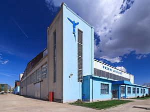
National Museum of Romanian Aviation
Museum in Bucharest, Romania
Distance: Approx. 2878 meters
Latitude and longitude: 44.47693889,26.11076944
The National Museum of Romanian Aviation (Romanian: Muzeul Național al Aviației Române) is an aviation museum owned by the General Staff of the Romanian Air Force. The museum was established on 2 March 1990, being initially located on the Otopeni military base. In 2006, it was moved in the hangars of the former Pipera Airport.
Weather in this IP's area
clear sky
20 Celsius
19 Celsius
18 Celsius
21 Celsius
1013 hPa
58 %
1013 hPa
1004 hPa
10000 meters
1.03 m/s
07:15:48
18:52:51