Country:
 Romania
Region:
City:
Latitude and Longitude:
Time Zone:
Postal Code:
IP information under different IP Channel
ip-api
Country
Region
City
ASN
Time Zone
ISP
Blacklist
Proxy
Latitude
Longitude
Postal
Route
IPinfo
Country
Region
City
ASN
Time Zone
ISP
Blacklist
Proxy
Latitude
Longitude
Postal
Route
MaxMind
Country
Region
City
ASN
Time Zone
ISP
Blacklist
Proxy
Latitude
Longitude
Postal
Route
Luminati
Country
RORegion
if
City
voluntari
ASN
Time Zone
Europe/Bucharest
ISP
Orange Romania S.A.
Latitude
Longitude
Postal
db-ip
Country
Region
City
ASN
Time Zone
ISP
Blacklist
Proxy
Latitude
Longitude
Postal
Route
ipdata
Country
Region
City
ASN
Time Zone
ISP
Blacklist
Proxy
Latitude
Longitude
Postal
Route
Popular places and events near this IP address
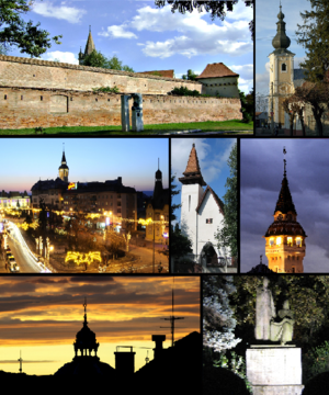
Târgu Mureș
City in Mureș County, Romania
Distance: Approx. 4451 meters
Latitude and longitude: 46.54555556,24.5625
Târgu Mureș (, Romanian: [ˈtɨrɡu ˈmureʃ] ; Hungarian: Marosvásárhely [ˈmɒroʃvaːʃaːrhɛj] ; German: Neumarkt am Mieresch) is the seat of Mureș County in the historical region of Transylvania, Romania. It is the 16th-largest city in Romania, with 116,033 inhabitants as of the 2021 census. It lies on the Mureș River, the second-longest river in Romania (after the Danube).

Transylvanian Plateau
Plateau in Romania
Distance: Approx. 3811 meters
Latitude and longitude: 46.5,24.5
The Transylvanian Plateau (Romanian: Podișul Transilvaniei; Hungarian: Erdélyi-medence) is a plateau in central Romania.

Cristești, Mureș
Commune in Mureș, Romania
Distance: Approx. 4183 meters
Latitude and longitude: 46.5,24.48333333
Cristești (Hungarian: Maroskeresztúr, Hungarian pronunciation: [mɒroʃkɛrstuːr]) is a commune in Mureș County, Transylvania, Romania that is composed of two villages:

Pănet
Commune in Mureș, Romania
Distance: Approx. 3564 meters
Latitude and longitude: 46.55,24.46666667
Pănet (Hungarian: Mezőpanit, Hungarian pronunciation: [mɛzøːpɒnit]) is a commune in Mureș County, Transylvania, Romania composed of five villages:

Sâncraiu de Mureș
Commune in Mureș, Romania
Distance: Approx. 2054 meters
Latitude and longitude: 46.55,24.52
Sâncraiu de Mureș (Hungarian: Marosszentkirály, Hungarian pronunciation: [ˈmɒrossɛntkiraːj] meaning "Holy King on the Mureș River") is a commune in Mureș County, Transylvania, Romania composed of two villages: Nazna / Náznánfalva Sâncraiu de Mureș Around 1930, Cornățel (Egerszeg) village was merged into Sâncraiu de Mureș.

Sângeorgiu de Mureș
Commune in Mureș, Romania
Distance: Approx. 3564 meters
Latitude and longitude: 46.55,24.46666667
Sângeorgiu de Mureș (Hungarian: Marosszentgyörgy [ˈmɒroʃsɛɲɟørɟ]) is a commune in Mureș County, Transylvania, Romania composed of three villages: Cotuș (Csejd), Sângeorgiu de Mureș, and Tofalău (Tófalva).

Palace of Culture (Târgu Mureș)
Distance: Approx. 4055 meters
Latitude and longitude: 46.54333333,24.55805556
The Palace of Culture (Romanian: Palatul Culturii, Hungarian: Kultúrpalota) is an edifice located in the centre of Târgu Mureș (Marosvásárhely), Romania. The building houses the Mureș County Library, the Mureș County Museum, and the State Philharmonic of Târgu Mureș. The Palace of Culture of Târgu Mureș is listed in the National Register of Historic Monuments.
Cuieșd (river)
River in Mureș County, Romania
Distance: Approx. 3577 meters
Latitude and longitude: 46.5121,24.4726
The Cuieșd (Hungarian: Mezőkövesdi-patak) is a right tributary of the river Mureș in Transylvania, Romania. It discharges into the Mureș in Cristești. Its length is 13 km (8.1 mi) and its basin size is 56 km2 (22 sq mi).
Pocloș
River in Mureș County, Romania
Distance: Approx. 1896 meters
Latitude and longitude: 46.5421,24.5286
The Pocloș ( Hungarian: Poklos, Poklos-patak ) is a left tributary of the river Mureș in Transylvania, Romania. It discharges into the Mureș in Târgu Mureș. Its length is 13 km (8.1 mi) and its basin size is 61 km2 (24 sq mi).

Castra of Cristești
Fort in the Roman province of Dacia
Distance: Approx. 2970 meters
Latitude and longitude: 46.51027778,24.48888889
Although not unanimously accepted, the existence of the castra of Cristești in the Roman province of Dacia is substantiated by bricks and tiles bearing the name of a Roman military unit, the Ala I Gallorum et Bosporanorum. The lack of any other traces of the Roman fort may easily be due to its destruction by the Mureș River. At Cristeşti, a Roman settlement from the 2nd and 3rd centuries AD was unearthed which was an important center of potters.
Târgu Mureș metropolitan area
Metropolitan area in Mureș, Romania
Distance: Approx. 3301 meters
Latitude and longitude: 46.53333333,24.55
The Târgu Mureș metropolitan area is a metropolitan area in Târgu Mureș, Romania. It was founded in 2005. It has a population of 209,532 as of the 2011 census.

Status Quo Ante Synagogue (Târgu Mureș)
Synagogue in Târgu Mures, Romania
Distance: Approx. 4121 meters
Latitude and longitude: 46.5453,24.5581
The Synagogue Status Quo Ante in Târgu Mureș (Romanian: Sinagoga Status Quo din Târgu Mureş), also known as the Great Temple in Târgu Mureş, the Big Temple in Târgu Mureş, or the Great Synagogue in Târgu Mureş, is a Status Quo Ante Jewish congregation and synagogue, located at 24 Aurel Filimon Street, Târgu Mureș, in Mureș county, Transylvania, Romania. Designed by Jakob Gartner in an eclectic architectural style, the synagogue was completed in 1900, during the Austro-Hungarian period. The synagogue was included on the National Register of Historic Monuments in Romania in 2004.
Weather in this IP's area
broken clouds
14 Celsius
14 Celsius
14 Celsius
14 Celsius
1011 hPa
94 %
1011 hPa
976 hPa
10000 meters
1.54 m/s
80 degree
75 %
07:25:58
18:54:25