Country:
Region:
City:
Latitude and Longitude:
Time Zone:
Postal Code:
IP information under different IP Channel
ip-api
Country
Region
City
ASN
Time Zone
ISP
Blacklist
Proxy
Latitude
Longitude
Postal
Route
Luminati
Country
Region
b
City
bucharest
ASN
Time Zone
Europe/Bucharest
ISP
Orange Romania S.A.
Latitude
Longitude
Postal
IPinfo
Country
Region
City
ASN
Time Zone
ISP
Blacklist
Proxy
Latitude
Longitude
Postal
Route
db-ip
Country
Region
City
ASN
Time Zone
ISP
Blacklist
Proxy
Latitude
Longitude
Postal
Route
ipdata
Country
Region
City
ASN
Time Zone
ISP
Blacklist
Proxy
Latitude
Longitude
Postal
Route
Popular places and events near this IP address

Costin Georgian metro station
Bucharest metro station
Distance: Approx. 2286 meters
Latitude and longitude: 44.4352,26.1689
Costin Georgian is a metro station in Bucharest; it was opened on 28 December 1981 as part of the second phase of Line 1 between Timpuri Noi and Republica. Formerly named Muncii after the eponymous boulevard that run just north (now Basarabia Blvd.), the station was chosen in 1992 to honor the late engineer Costin Georgian, General Manager of the Metro operator Metrorex, after his sudden death on 25 August 1992, the eve of the Basarab station opening day.

Republica metro station
Bucharest metro station
Distance: Approx. 1833 meters
Latitude and longitude: 44.43439,26.18573
Republica is a metro station in Bucharest, servicing the heavy machinery plant with the same name and the Cora hypermarket located in the vicinity. Also, the Titan Sud train station is located in the immediate vicinity. It is also the terminus for most trains of M1, as between Republica and Pantelimon metro station, the only service provided is a train every 20 minutes.

Pantelimon metro station
Bucharest metro station
Distance: Approx. 1152 meters
Latitude and longitude: 44.44091,26.19185
Pantelimon (also known informally as Antilopa) is a metro station on Line M1 of the Bucharest Metro. Situated in Pantelimon neighbourhood, adjacent to the town of Pantelimon, it is the terminus of Line M1 and was opened in May 1991 as a one-station extension from Republica. The station was built only to serve the Pantelimon Subway Depot and the workers of the defunct Antilopa factory, which is located in the close vicinity.

Pantelimon, Ilfov
Town in Ilfov, Romania
Distance: Approx. 989 meters
Latitude and longitude: 44.45,26.2
Pantelimon (Romanian pronunciation: [panteliˈmon]) is a town in Ilfov County, Muntenia, Romania. The town — bordered to the west by the Romanian capital, Bucharest — has an area of 69 km2 (27 sq mi). Its name is derived from the Greek saint Panteleimon.

Dobroești
Commune in Ilfov, Romania
Distance: Approx. 561 meters
Latitude and longitude: 44.45111111,26.18055556
Dobroești is a commune in the east of Ilfov County, Muntenia, Romania, right off the limits of Bucharest's Sector 2. It is composed of two villages, Dobroești and Fundeni. The name Dobroești is derived from South Slavic/Bulgarian "Dobro" (good) and Romanian suffix -ești.

Pantelimon, Bucharest
Distance: Approx. 2439 meters
Latitude and longitude: 44.44263333,26.15911944
Pantelimon is a neighbourhood located in north-eastern Bucharest, Romania, in Sector 2. Outside Bucharest, there is an adjacent town named Pantelimon, administered separately. The Pantelimon district is named after Saint Pantaleon (Pantelimon in Romanian), and hosts Arena Națională, the largest football stadium in Romania.

Titan Sud
Railway station in Bucharest, Romania
Distance: Approx. 1845 meters
Latitude and longitude: 44.434375,26.18447778
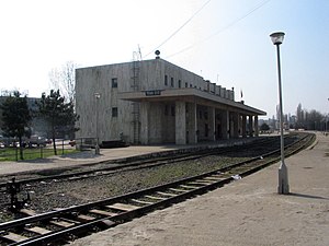
Titan Sud (formerly known as Gara 23 August) is a small train station located in the Eastern side of Bucharest, Romania, near the Republica metro station and the Republica Factory (formerly 23 August Factory). The railway station was built in 1985, mainly to serve commuters on the Bucharest–Oltenița line. As of 2006, the station serves only four commuter train lines, all of them linking to Oltenița.
Mărcuța Church
Distance: Approx. 1393 meters
Latitude and longitude: 44.44444444,26.1725
Mărcuța Church (Romanian: Biserica Mărcuța) is a Romanian Orthodox church in Bucharest, Romania on the east side of the Pantelimon district. Built in 1587, it is one of the oldest structures still in use today in Romania. In the past the church served the Mărcuța Monastery which was situated on the outskirts of the city.

Lake Fundeni
Distance: Approx. 2099 meters
Latitude and longitude: 44.451122,26.161194
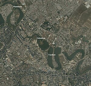
Lake Fundeni is a man-made lake on the Colentina River in Bucharest, Sector 2. It has a surface of 35 ha (86 acres), length of 2.1 km (1.3 mi), width of 200–800 m, a depth between 1 and 5 meters, and a volume of 800,000 m3 (1,000,000 cu yd). In the middle of the lake there is an island with a surface area of 3.16 ha (7.8 acres).

Fundeni, Bucharest
Distance: Approx. 2211 meters
Latitude and longitude: 44.46074,26.163511
Fundeni is a district in Sector 2 of Bucharest, Romania. It is situated in the northeastern outskirts of the city, on the left bank of the Colentina River, downstream of Plumbuita Monastery, and near the Fundeni Lake that was formed on the river. On its west and north-west are located the Colentina and Andronache neighbourhoods, on its north the town of Voluntari and on its east the commune of Dobroești.

Metaloglobus Stadium
Distance: Approx. 977 meters
Latitude and longitude: 44.44222222,26.185
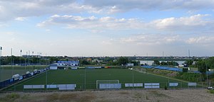
The Metaloglobus Stadium is a multi-use stadium in Bucharest, Romania. It is used mostly for football matches and is the home ground of Metaloglobus București. The stadium holds 1,000 people.

Popa Nan Church
Heritage site in Bucharest, Romania
Distance: Approx. 2980 meters
Latitude and longitude: 44.464833,26.155667
The Popa Nan Church (Romanian: Biserica Popa Nan) is a Romanian Orthodox church located at 47A Popa Nan Street in Bucharest, Romania. It is dedicated to Saints Constantine and Helena. The first small, single-domed church on the site was built in 1719.
Weather in this IP's area
mist
6 Celsius
6 Celsius
4 Celsius
7 Celsius
1006 hPa
90 %
1006 hPa
998 hPa
7000 meters
1.03 m/s
39 %
07:18:25
16:43:47
