Country:
 Romania
Region:
City:
Latitude and Longitude:
Time Zone:
Postal Code:
IP information under different IP Channel
ip-api
Country
Region
City
ASN
Time Zone
ISP
Blacklist
Proxy
Latitude
Longitude
Postal
Route
IPinfo
Country
Region
City
ASN
Time Zone
ISP
Blacklist
Proxy
Latitude
Longitude
Postal
Route
MaxMind
Country
Region
City
ASN
Time Zone
ISP
Blacklist
Proxy
Latitude
Longitude
Postal
Route
Luminati
Country
RORegion
if
City
voluntari
ASN
Time Zone
Europe/Bucharest
ISP
Orange Romania S.A.
Latitude
Longitude
Postal
db-ip
Country
Region
City
ASN
Time Zone
ISP
Blacklist
Proxy
Latitude
Longitude
Postal
Route
ipdata
Country
Region
City
ASN
Time Zone
ISP
Blacklist
Proxy
Latitude
Longitude
Postal
Route
Popular places and events near this IP address

Slatina, Romania
Municipality in Olt, Romania
Distance: Approx. 8839 meters
Latitude and longitude: 44.42972222,24.36416667
Slatina (Romanian pronunciation: [ˈslatina], Bulgarian: Слатина) is the capital city of Olt County, Romania, on the river Olt. It is located in the south of Romania, on the eastern side of the river Olt, in the historical region of Muntenia. The population was 63,487 in 2021; the urban area has around 85,000 inhabitants.
Vaslui (Oltișor)
River in Olt County, Romania
Distance: Approx. 5169 meters
Latitude and longitude: 44.39472222,24.28361111
The Vaslui is a right tributary of the river Oltișor in Romania. It flows into the Oltișor in Găneasa. Its length is 17 km (11 mi) and its basin size is 33 km2 (13 sq mi).
Beica (Olt)
River in Olt County, Romania
Distance: Approx. 4422 meters
Latitude and longitude: 44.4481,24.3062
The Beica is a tributary of the river Olt in Romania. It joins the Olt through the Oporelu Canal, into which it flows near Arcești-Cot. Its length is 50 km (31 mi) and its basin size is 186 km2 (72 sq mi).
Mamu (river)
River in Olt, Romania
Distance: Approx. 8551 meters
Latitude and longitude: 44.5077,24.2912
The Mamu is a tributary of the river Olt in Romania. It joins the Olt through the Oporelu Canal, into which it flows in Colibași. Its length is 35 km (22 mi) and its basin size is 107 km2 (41 sq mi).
Strehareți
River in Olt County, Romania
Distance: Approx. 6145 meters
Latitude and longitude: 44.4387,24.3305
The Strehareți is a left tributary of the river Olt in Romania. It flows into the Olt near the city of Slatina. Its length is 11 km (6.8 mi) and its basin size is 44 km2 (17 sq mi).

Piatra-Olt
Town in Olt, Romania
Distance: Approx. 7769 meters
Latitude and longitude: 44.36666667,24.26666667
Piatra-Olt is a town in Olt County, Oltenia, Romania. The town administers five villages: Bistrița Nouă, Criva de Jos, Criva de Sus, Enoșești and Piatra. The town is an important railway station and road intersection.
Găneasa, Olt
Commune in Olt, Romania
Distance: Approx. 4646 meters
Latitude and longitude: 44.4,24.28333333
Găneasa is a commune in Olt County, Oltenia, Romania, in the vicinity of Piatra-Olt town. It is composed of five villages: Dranovățu, Găneasa, Grădiștea, Izvoru, and Oltișoru.
Slătioara, Olt
Commune in Olt, Romania
Distance: Approx. 6424 meters
Latitude and longitude: 44.4,24.31666667
Slătioara is a commune in Olt County, Oltenia, Romania. It is composed of two villages, Salcia and Slătioara.

Pleșoiu
Commune in Olt, Romania
Distance: Approx. 3596 meters
Latitude and longitude: 44.46666667,24.26666667
Pleșoiu is a commune in Olt County, Oltenia, Romania. It is composed of seven villages: Arcești, Arcești-Cot, Cocorăști, Doba, Pleșoiu, Schitu din Deal and Schitu din Vale.
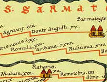
Acidava
Distance: Approx. 6995 meters
Latitude and longitude: 44.375411,24.277634
Acidava (Acidaua) was a Dacian and later Roman town and fort on the Olt river near the lower Danube. The settlement's remains are located in today's Enoşeşti, Olt County, Oltenia, Romania.
Acidava (castra)
Distance: Approx. 6492 meters
Latitude and longitude: 44.37805556,24.26472222
Castra Acidava was a fort in the Roman province of Dacia, The toponym is attested in the Peutinger Table. built near the ancient town of Acidava. It was part of the Limes Alutanus frontier system built under emperor Hadrian running north–south along the Alutus (Olt) river.

Radu Greceanu National College
Distance: Approx. 7794 meters
Latitude and longitude: 44.4319,24.3512
Radu Greceanu National College (Romanian: Colegiul Național Radu Greceanu) is a high school located at 8 Nicolae Bălcescu Street, Slatina, Romania. The school was established in 1886 and declared a gymnasium two years later. In 1891, it was named after Radu Greceanu, an 18th-century chronicler.
Weather in this IP's area
scattered clouds
20 Celsius
19 Celsius
19 Celsius
21 Celsius
1013 hPa
38 %
1013 hPa
998 hPa
10000 meters
2.33 m/s
2.28 m/s
89 degree
33 %
07:23:17
19:00:23