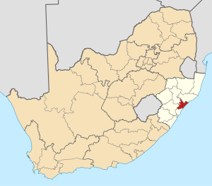
Country:
Region:
City:
Latitude and Longitude:
Time Zone:
Postal Code:
IP information under different IP Channel
ip-api
Country
Region
City
ASN
Time Zone
ISP
Blacklist
Proxy
Latitude
Longitude
Postal
Route
Luminati
Country
Region
kzn
City
kwadukuza
ASN
Time Zone
Africa/Johannesburg
ISP
RMS-Powertronics
Latitude
Longitude
Postal
IPinfo
Country
Region
City
ASN
Time Zone
ISP
Blacklist
Proxy
Latitude
Longitude
Postal
Route
db-ip
Country
Region
City
ASN
Time Zone
ISP
Blacklist
Proxy
Latitude
Longitude
Postal
Route
ipdata
Country
Region
City
ASN
Time Zone
ISP
Blacklist
Proxy
Latitude
Longitude
Postal
Route
Popular places and events near this IP address
KwaDukuza
Place in KwaZulu-Natal, South Africa
Distance: Approx. 1110 meters
Latitude and longitude: -29.33333333,31.29166667
KwaDukuza, previously known as Stanger, is a town in KwaZulu-Natal, South Africa. In 2006, the municipal name was changed to KwaDukuza (which incorporates towns such as Stanger, Ballito and Shakaskraal), but the Zulu people in the area called it "Dukuza" well before then. The city has undergone minor economic construction since 2015, having built a multi-million rand regional shopping mall in 2018.
2002 Charlotte's Dale train collision
Distance: Approx. 7773 meters
Latitude and longitude: -29.39333333,31.26277778
The Charlotte's Dale train crash was the collision of a commuter train with a freight train in the town of Charlotte's Dale, 42 miles from Durban in South Africa on 6 February 2002. The commuter train was a regular service traveling from Durban to outlying towns and most of the passengers on board were school children returning home following the end of school shortly before. As it approached the town of Charlotte's Dale at 4.00pm, the train collided at high speed with the rear of a stationary freight train on the same line.

ILembe District Municipality
District municipality in KwaZulu-Natal, South Africa
Distance: Approx. 1919 meters
Latitude and longitude: -29.33333333,31.28333333
iLembe is one of the 11 district municipalities of KwaZulu-Natal province in South Africa. The seat of iLembe is KwaDukuza. The majority (82%) of its 606,809 people speak isiZulu as their first language (2011 census).

Stanger Secondary School
High school in South Africa
Distance: Approx. 1399 meters
Latitude and longitude: -29.33347222,31.28869444
Stanger Secondary School is a public high school located in Stanger / KwaDukuza on the north coast of Kwazulu Natal in South Africa.

Shaka Memorial
Distance: Approx. 1148 meters
Latitude and longitude: -29.34005278,31.29447222
The Shaka Memorial is a provincial heritage site in KwaDukuza in the KwaZulu-Natal province of South Africa. It marks the resting place of the Zulu King Shaka near the site where he was assassinated by his half-brothers Dingane and Mhlangana while sitting on a rock near the barracks at his capital Dukuza. According to the 1938 Government Gazette, the monument was made in Newcastle and erected in 1932 on the site of King Shaka's grave.

Stanger Manor Secondary School
High school in South Africa
Distance: Approx. 2686 meters
Latitude and longitude: -29.32222222,31.27833333
Stanger Manor Secondary School is a public high school located in Stanger, KwaDukuza, on the north coast of South Africa.
Darnall, KwaZulu-Natal
Place in KwaZulu-Natal, South Africa
Distance: Approx. 9623 meters
Latitude and longitude: -29.26666667,31.36666667
Darnall is a town in Ilembe District Municipality in the KwaZulu-Natal province of South Africa. Darnall is home to the Darnall sugar factory.
Groutville
Town in KwaZulu-Natal, South Africa
Distance: Approx. 8322 meters
Latitude and longitude: -29.388,31.245
Groutville is a town in Ilembe District Municipality in the KwaZulu-Natal province of South Africa. Home of the late ANC leader, Chief Albert Luthuli, Home to the late RT Rev j. Mdelwa Hlongwane founder to The Bantu Methodist Church.
New Guelderland
Place in KwaZulu-Natal, South Africa
Distance: Approx. 3156 meters
Latitude and longitude: -29.32,31.332
New Guelderland is a town in KwaDukuza in the KwaZulu-Natal province of South Africa. It was established in 1859, when Theodorus Colenbrander brought a party of 80 Dutch immigrants to his settlement and named it after Guelderland in the Netherlands.
Weather in this IP's area
overcast clouds
16 Celsius
16 Celsius
16 Celsius
16 Celsius
1016 hPa
82 %
1016 hPa
1012 hPa
10000 meters
5.23 m/s
9.94 m/s
224 degree
100 %
04:57:49
18:18:56