Country:
 Poland
Region:
City:
Latitude and Longitude:
Time Zone:
Postal Code:
IP information under different IP Channel
ip-api
Country
Region
City
ASN
Time Zone
ISP
Blacklist
Proxy
Latitude
Longitude
Postal
Route
IPinfo
Country
Region
City
ASN
Time Zone
ISP
Blacklist
Proxy
Latitude
Longitude
Postal
Route
MaxMind
Country
Region
City
ASN
Time Zone
ISP
Blacklist
Proxy
Latitude
Longitude
Postal
Route
Luminati
Country
 SE
SEASN
Time Zone
Europe/Stockholm
ISP
Arelion Sweden AB
Latitude
Longitude
Postal
db-ip
Country
Region
City
ASN
Time Zone
ISP
Blacklist
Proxy
Latitude
Longitude
Postal
Route
ipdata
Country
Region
City
ASN
Time Zone
ISP
Blacklist
Proxy
Latitude
Longitude
Postal
Route
Popular places and events near this IP address

Second Polish Republic
Country in Central and Eastern Europe (1918–1939)
Distance: Approx. 81 meters
Latitude and longitude: 52.23,21.01111111
The Second Polish Republic, at the time officially known as the Republic of Poland, was a country in Central and Eastern Europe that existed between 7 October 1918 and 6 October 1939. The state was established in the final stage of World War I. The Second Republic ceased to exist in 1939, after Poland was invaded by Nazi Germany, the Soviet Union, and the Slovak Republic, marking the beginning of the European theatre of the Second World War. The Polish government-in-exile was established in Paris and later London after the fall of France in 1940.

Warsaw
Capital and largest city of Poland
Distance: Approx. 81 meters
Latitude and longitude: 52.23,21.01111111
Warsaw, officially the Capital City of Warsaw, is the capital and largest city of Poland. The metropolis stands on the River Vistula in east-central Poland. Its population is officially estimated at 1.86 million residents within a greater metropolitan area of 3.27 million residents, which makes Warsaw the 7th most-populous city in the European Union.

Warsaw Uprising
Major World War II operation by the Polish resistance Home Army
Distance: Approx. 99 meters
Latitude and longitude: 52.23,21.01083333
The Warsaw Uprising (Polish: powstanie warszawskie; German: Warschauer Aufstand), sometimes referred to as the August Uprising (Polish: powstanie sierpniowe), was a major World War II operation by the Polish underground resistance to liberate Warsaw from German occupation. It occurred in the summer of 1944, and it was led by the Polish resistance Home Army (Polish: Armia Krajowa). The uprising was timed to coincide with the retreat of the German forces from Poland ahead of the Soviet advance.

Jerusalem Avenue, Warsaw
Distance: Approx. 49 meters
Latitude and longitude: 52.23,21.01166667
Jerusalem Avenue (Polish: Aleje Jerozolimskie) is one of the principal streets of the capital city of Warsaw in Poland. It runs through the City Centre along the East-West axis, linking the western borough of Wola with the bridge on the Vistula River and the borough of Praga on the other side of the river.

Warsaw Uprising (1794)
Armed uprising by Polish forces against the Russian garrison of Warsaw in 1794
Distance: Approx. 99 meters
Latitude and longitude: 52.23,21.01083333
The Warsaw Uprising of 1794 or Warsaw Insurrection (Polish: insurekcja warszawska) was an armed insurrection by the people of Warsaw early in the Kościuszko Uprising. Supported by the Polish Army, the uprising aimed to throw off control by the Russian Empire of the Polish capital city (Warsaw). It began on 17 April 1794, soon after Tadeusz Kościuszko's victory at the Battle of Racławice.

Marszałkowska Street, Warsaw
Street in downtown Warsaw
Distance: Approx. 59 meters
Latitude and longitude: 52.22916667,21.01222222
Marszałkowska Street (Polish: ulica Marszałkowska), also known by its English name Marshall Street, is one of the main thoroughfares of Warsaw, Poland, located in the district of Downtown (Śródmieście). It runs along the north–south axis, from Bank Square in the north to the Union of Lublin Square in the south.

1979 Warsaw gas explosion
Distance: Approx. 95 meters
Latitude and longitude: 52.23055556,21.01222222
The 1979 explosion at PKO Bank Polski's Rotunda office in Warsaw took place on 15 February 1979, at 12:37 p.m. As a result, 49 people died and 135 were injured. Officially, the tragedy was caused by a gas explosion, but in the course of time much speculation appeared, and Varsovians talked among themselves that the building had been blown up by a bomb.
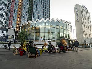
PKO Rotunda
Distance: Approx. 97 meters
Latitude and longitude: 52.23055556,21.0125
PKO Rotunda is a rotunda-type building owned by the PKO BP bank in the center of Warsaw, Poland. Designed from 1960–1969 by chief architect Jerzy Jakubowicz, it was the site of a gas explosion in February 1979, which killed 49 people. It was opened again in October the same year.
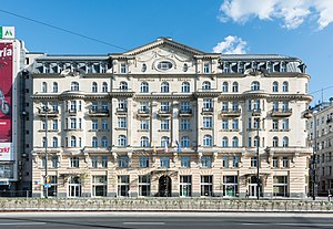
Hotel Polonia Palace
Distance: Approx. 109 meters
Latitude and longitude: 52.22941667,21.01066667
The Polonia Palace Hotel is a historic four-star hotel opened in 1913 and located in the heart of Warsaw on Jerusalem Avenue. It is the capital’s second oldest hotel after the Hotel Bristol, Warsaw. Together with the adjacent Metropol Hotel and the MDM Hotel, it is managed by the Syrena Hotel Group.

Novotel Warszawa Centrum
Skyscraper hotel in Warsaw, Poland
Distance: Approx. 101 meters
Latitude and longitude: 52.2294,21.0136
Novotel Warszawa Centrum is a 33-story, 111-meter skyscraper hotel in Warsaw, Poland.

Chabad Lubavitch of Poland
Chabad synagogue in Warsaw, Poland
Distance: Approx. 30 meters
Latitude and longitude: 52.22977,21.01178
The Chabad Lubavitch of Poland, also called the Chabad House Warsaw, Poland, is a Chabad Hasidic Jewish congregation and synagogue, located at 19/508 Słomińskiego Street, in Warsaw, in the Masovian Voivodeship of Poland. Another temple of this type in Poland (ongoing ownership disputes) is the Isaac Jakubowicz Synagogue in Kraków. The synagogue was founded in December 2005.

Widok Towers
Skyscraper in Warsaw, Poland
Distance: Approx. 107 meters
Latitude and longitude: 52.23058333,21.01283333
Widok Towers is an office skyscraper in Warsaw, Poland, located at 44 Jerusalem Avenue, in the Downtown district. It was designed by Piotr Bujnowski and Martin Tröthan, and opened in 2020.
Weather in this IP's area
clear sky
25 Celsius
24 Celsius
24 Celsius
27 Celsius
1018 hPa
36 %
1018 hPa
1005 hPa
10000 meters
7.2 m/s
130 degree
05:59:24
19:08:04