Country:
 Nigeria
Region:
City:
Latitude and Longitude:
Time Zone:
Postal Code:
IP information under different IP Channel
ip-api
Country
Region
City
ASN
Time Zone
ISP
Blacklist
Proxy
Latitude
Longitude
Postal
Route
IPinfo
Country
Region
City
ASN
Time Zone
ISP
Blacklist
Proxy
Latitude
Longitude
Postal
Route
MaxMind
Country
Region
City
ASN
Time Zone
ISP
Blacklist
Proxy
Latitude
Longitude
Postal
Route
Luminati
Country
NGASN
Time Zone
Africa/Lagos
ISP
Xpress-Payment
Latitude
Longitude
Postal
db-ip
Country
Region
City
ASN
Time Zone
ISP
Blacklist
Proxy
Latitude
Longitude
Postal
Route
ipdata
Country
Region
City
ASN
Time Zone
ISP
Blacklist
Proxy
Latitude
Longitude
Postal
Route
Popular places and events near this IP address

Ikeja
Capital city of Lagos State, Nigeria
Distance: Approx. 2264 meters
Latitude and longitude: 6.6,3.35
Ikeja is the capital city of Lagos State in southwestern Nigeria. Its population, as of the 2006 census, is 313,196. Prior to the emergence of military rule in the early 1980s, Ikeja was a well planned, clean and quiet residential and commercial town with shopping malls, pharmacies and government reservation areas.

Murtala Muhammed International Airport
International airport serving Lagos, Nigeria
Distance: Approx. 3387 meters
Latitude and longitude: 6.57722222,3.32111111
Murtala Muhammed International Airport (MMIA) (IATA: LOS, ICAO: DNMM) (Yoruba: Pápá Ọkọ̀ Òfurufú Káríayé Múrítàlá Mùhammẹ̀d) is an international airport located in Ikeja, Lagos State, Nigeria, and is the major airport serving the entire state. The airport was initially built during World War II and is named after Murtala Muhammed (1938–1976), the fourth military ruler of Nigeria.
John Holt plc
Distance: Approx. 2814 meters
Latitude and longitude: 6.5975,3.36972222
John Holt plc is a Nigerian conglomerate that participates in many areas of the economy. The Nigerian company is a subsidiary of John Holt & Co. (Liverpool) Ltd, a British company.

Indian Language School
School in Ilupeju, Lagos, Nigeria
Distance: Approx. 3396 meters
Latitude and longitude: 6.55188,3.36416
The Indian Language School was established in Lagos, Nigeria in 1982 in light of the growing Indian community in the city. Indian Language School is a private school setup by the Indian high commission in Nigeria. It was originally set up in a residential neighborhood at 11 Johnson Street, Illupeju, Lagos.
2002 Lagos armoury explosion
Accidental bomb detonation
Distance: Approx. 1359 meters
Latitude and longitude: 6.5735,3.3622
The Lagos armoury explosion was the accidental detonation of a large stock of high explosives at a military storage facility in the city of Lagos, Nigeria, on 27 January 2002. The fires created by the debris from this explosion burnt down a large section of Northern Lagos, and created a panic that spread to other areas. As people fled the flames, many stumbled into a concealed canal and drowned.
Vivian Fowler Memorial College for Girls
School in Ikeja, Lagos, Lagos State, Nigeria
Distance: Approx. 3400 meters
Latitude and longitude: 6.60878,3.36112
The Vivian Fowler Memorial College for Girls is an all-girls Independent college founded in 1991 by Chief Mrs. Leila Fowler in Nigeria. It is located in the Ikeja suburb of the city of Lagos.

Ikeja City Mall
Shopping mall in Lagos State, Nigeria
Distance: Approx. 2066 meters
Latitude and longitude: 6.5833,3.3333
The Ikeja City Mall is located at Alausa in Ikeja, Lagos State. It is the first of its kind on the Mainland of Metropolitan Lagos. There is a Silverbird cinema in the mall as well as Shoprite, eateries, clothing brands and clothing stores and different bank ATMs.
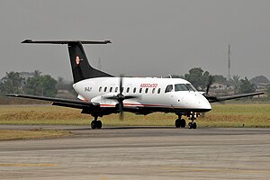
Associated Aviation Flight 361
2013 aviation accident
Distance: Approx. 3589 meters
Latitude and longitude: 6.56342222,3.32363889
Associated Aviation Flight 361 was a domestic charter flight operated by Associated Aviation that on 3 October 2013 crashed on takeoff from Lagos, Nigeria, killing 16 of the 20 people on board. The aircraft, a twin turboprop Embraer 120 Brasilia, was transporting the body of Nigerian politician Olusegun Agagu to Akure for burial.
Avi-Cenna International School
School in Lagos State, Nigeria
Distance: Approx. 946 meters
Latitude and longitude: 6.5882,3.3523
Avi-Cenna International School is a government-approved co-educational British curriculum school located in the GRA part of Ikeja in Lagos State. Founded in 1989, the school focuses on the "promotion of moral and ethical values" with the view of "developing interpersonal and leadership skills" of her students.

Lagos State University Teaching Hospital
Hospital in Lagos State, Nigeria
Distance: Approx. 1596 meters
Latitude and longitude: 6.590608,3.342225
Lagos State University Teaching Hospital popularly known as LASUTH is a state-owned teaching hospital in Lagos, Nigeria, attached to the Lagos State University. It is in Ikeja – the state's capital. LASUTH also shares structures with the College of Medicine, Lagos State University.

Sheraton Lagos Hotel
Hotel in Lagos, Nigeria
Distance: Approx. 1034 meters
Latitude and longitude: 6.58355,3.36015
Sheraton Lagos Hotel is a five-star conference centre hotel in Lagos

1995 Lagos Harka Air Services Tu-134 crash
Distance: Approx. 3380 meters
Latitude and longitude: 6.577369,3.321156
The 1995 Lagos Harka Air Services Tu-134 crash occurred on 24 June 1995, when a Tupolev Tu-134A operated by Harka Air Services from Kaduna to Lagos overran the runway upon landing at Lagos' Murtala Muhammed International Airport crashed into a ditch and caught fire. The flight was carrying 74 passengers and 6 crew members, of which 16 died in the accident.
Weather in this IP's area
light rain
30 Celsius
37 Celsius
30 Celsius
30 Celsius
1009 hPa
79 %
1009 hPa
1005 hPa
10000 meters
5.14 m/s
180 degree
75 %
06:32:40
18:30:01