80.87.220.27 - IP Lookup: Free IP Address Lookup, Postal Code Lookup, IP Location Lookup, IP ASN, Public IP
Country:
Region:
City:
Location:
Time Zone:
Postal Code:
IP information under different IP Channel
ip-api
Country
Region
City
ASN
Time Zone
ISP
Blacklist
Proxy
Latitude
Longitude
Postal
Route
Luminati
Country
Region
zi
City
namestovo
ASN
Time Zone
Europe/Bratislava
ISP
DSI DATA, a. s.
Latitude
Longitude
Postal
IPinfo
Country
Region
City
ASN
Time Zone
ISP
Blacklist
Proxy
Latitude
Longitude
Postal
Route
IP2Location
80.87.220.27Country
Region
zilinsky kraj
City
dolny kubin
Time Zone
Europe/Bratislava
ISP
Language
User-Agent
Latitude
Longitude
Postal
db-ip
Country
Region
City
ASN
Time Zone
ISP
Blacklist
Proxy
Latitude
Longitude
Postal
Route
ipdata
Country
Region
City
ASN
Time Zone
ISP
Blacklist
Proxy
Latitude
Longitude
Postal
Route
Popular places and events near this IP address

Árva County
County of the Kingdom of Hungary
Distance: Approx. 803 meters
Latitude and longitude: 49.21666667,19.3
Árva County (Hungarian: Árva vármegye, Latin: Comitatus Arvensis, Slovak: Oravská stolica/župa, German: Komitat Arwa, Polish: Komitat Orawa) was an administrative county (comitatus) of the Kingdom of Hungary since the 14th century until 1920. Its territory is now in northern Slovakia and southern Poland. Today, the Slovak name is only used as an informal designation of the corresponding territory (see Orava region).
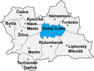
Dolný Kubín District
District in Žilina Region, Slovakia
Distance: Approx. 599 meters
Latitude and longitude: 49.20888889,19.29527778
Dolný Kubín District (okres Dolný Kubín) is a district in the Žilina Region of central Slovakia. The district is located in a hilly area north of the Malá Fatra and Choč mountain ranges. The engineering, electrical engineering, metallurgy and wood processing industries represent the core of this district's economy.

Bziny
Distance: Approx. 2792 meters
Latitude and longitude: 49.23333333,19.31666667
Bziny (Hungarian: Bezine) is a village and municipality in Dolný Kubín District in the Zilina Region of northern Slovakia.

Medzibrodie nad Oravou
Village and municipality in Dolný Kubín District in northern Slovakia
Distance: Approx. 4283 meters
Latitude and longitude: 49.23333333,19.35
Medzibrodie nad Oravou (Hungarian: Medzibrogy) is a village and municipality in Dolný Kubín District in the Žilina Region of northern Slovakia. It stands at 549 m (1801 ft) and has a population of 475.

Vyšný Kubín
Village in Slovakia
Distance: Approx. 2957 meters
Latitude and longitude: 49.18333333,19.3
Vyšný Kubín (Hungarian: Felsőkubin; Hungarian pronunciation: [ˈfɛlʃøːkubin]) is a village and municipality in Dolný Kubín District in the Žilina Region of northern Slovakia.

Jasenová
Distance: Approx. 3830 meters
Latitude and longitude: 49.17583333,19.295
Jasenová (Hungarian: Jaszenova) is a village and municipality in Dolný Kubín District in the Zilina Region of northern Slovakia. It has population of 401 people. Its name comes from the Slovak word Jaseň, which is a kind of tree often found in the area.

Oravská Poruba
Distance: Approx. 3172 meters
Latitude and longitude: 49.1944,19.2667
Oravská Poruba (Hungarian: Poruba) is a village and municipality in Dolný Kubín District in the Zilina Region of northern Slovakia. It stands at 487 m (1598 ft) and has a population of 1089.

Leštiny
Village in Slovakia
Distance: Approx. 4491 meters
Latitude and longitude: 49.18333333,19.35
Leštiny (Hungarian: Lestin) is a village and municipality in Dolný Kubín District in the Žilina Region of northern Slovakia. The village contains an Evangelical wooden church constructed in 1688-89 by local carpenters.

St Catherine's Church, Dolný Kubín
Distance: Approx. 1119 meters
Latitude and longitude: 49.2,19.3
St Catherine's Church, Dolný Kubín, is a Roman Catholic church in Slovakia. The present Gothic church was built on the remnants of the first church of Dolný Kubín in the 14th century. The interior of the church was painted by "Slovenske umenie manifacture" in 1939.

Dolný Kubín
Town in Slovakia
Distance: Approx. 437 meters
Latitude and longitude: 49.21055556,19.2975
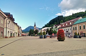
Dolný Kubín (Slovak pronunciation: [ˈdɔlniː ˈkubiːn] ; also known by other names) is a town in northern Slovakia in the Žilina Region. It is the historical capital and the largest settlement of the Orava region.

Choč Mountains
Mountain range in Slovakia
Distance: Approx. 5272 meters
Latitude and longitude: 49.16666667,19.33333333
The Choč Mountains (in Slovak, Chočské vrchy) are a range of mountains in north-central Slovakia, a portion of the Fatra-Tatra Area of the Inner Western Carpathians. The range is 24 kilometers long and on average only 4 kilometers wide. Highest peak is Veľký Choč at 1 611 metres above sea level.

Štadión MUDr. Ivana Chodáka
Football stadium in Dolný Kubín, Slovakia
Distance: Approx. 925 meters
Latitude and longitude: 49.20633333,19.29183333
Stadium MUDr. Ivan Chodák (Slovak: Štadión MUDr. Ivana Chodáka) is a home football stadium in Dolný Kubín, Slovakia.
Weather in this IP's area
overcast clouds
1 Celsius
-2 Celsius
1 Celsius
2 Celsius
1019 hPa
74 %
1019 hPa
955 hPa
10000 meters
3.95 m/s
7.71 m/s
22 degree
99 %