Country:
 Germany
Region:
City:
Latitude and Longitude:
Time Zone:
Postal Code:
IP information under different IP Channel
ip-api
Country
Region
City
ASN
Time Zone
ISP
Blacklist
Proxy
Latitude
Longitude
Postal
Route
IPinfo
Country
Region
City
ASN
Time Zone
ISP
Blacklist
Proxy
Latitude
Longitude
Postal
Route
MaxMind
Country
Region
City
ASN
Time Zone
ISP
Blacklist
Proxy
Latitude
Longitude
Postal
Route
Luminati
Country
DEASN
Time Zone
Europe/Berlin
ISP
Pixel X e.K.
Latitude
Longitude
Postal
db-ip
Country
Region
City
ASN
Time Zone
ISP
Blacklist
Proxy
Latitude
Longitude
Postal
Route
ipdata
Country
Region
City
ASN
Time Zone
ISP
Blacklist
Proxy
Latitude
Longitude
Postal
Route
Popular places and events near this IP address

Gehry Tower
Distance: Approx. 164 meters
Latitude and longitude: 52.37472222,9.73055556
Gehry Tower is a nine-story building constructed by architect Frank Gehry; it is located at the Steintor, Goethestraße 13a, in Hanover, Germany. The building was commissioned by the city-owned Hanover Transport Services (üstra), for whom Gehry also designed a bus stop in the city. Constructed of stainless steel, the tower is memorable for the noticeable twist in its outer façade on a ferroconcrete core, making optimal use of the relatively small piece of ground on which it is located.

Kestnergesellschaft
German art institution
Distance: Approx. 180 meters
Latitude and longitude: 52.3775,9.73166667
Kestner Gesellschaft (Kestner Society) is an art institution in Hanover, Germany, founded in 1916 to promote the arts. Its founders included the painter Wilhelm von Debschitz (1871–1948). The association blossomed under the management of Alexander Dorner and Justus Bier, pioneering modern art.
GISMA Business School
Distance: Approx. 234 meters
Latitude and longitude: 52.37472222,9.72916667
Gisma University of Applied Sciences is a privately owned University in Germany with its main site in Potsdam and a branch in Berlin. It was launched in September 1999 as a joint initiative by the German state of Lower Saxony and several large private-sector companies that were based there. In financial difficulty after its partnership with Krannert School of Management ended, GISMA was rescued from bankruptcy when it was bought by the for-profit education company Global University Systems in September 2013.

Steintor (Hanover Stadtbahn station)
Underground rail station in Hanover
Distance: Approx. 35 meters
Latitude and longitude: 52.3758,9.7325
Steintor is a Hanover Stadtbahn station served by all C and D lines. The C lines were built underground, which is the junction for all lines continuing west. Lines 4, 5 and 16 branch off eastwards towards the next station, Königsworther Platz (the latter one is the terminus at that station), while lines 6 and 11 branch off northbound, where the next station is Christuskirche.

Radio ffn
Radio station
Distance: Approx. 204 meters
Latitude and longitude: 52.3776,9.7309
Radio ffn is a commercial radio station operated by Funk & Fernsehen Nordwestdeutschland GmbH & Co. KG in Lower Saxony, Germany. It broadcasts from regional studios in Braunschweig, Göttingen, Hanover (station HQ), Lüneburg, Oldenburg, and Osnabrück.

Kreuzkirche, Hanover
Church in Hanover, Lower Saxony
Distance: Approx. 282 meters
Latitude and longitude: 52.373391,9.732596
The Church of the Holy Cross (German: Kreuzkirche) is a Lutheran church in the centre of Hanover, the capital of Lower Saxony, Germany. A Gothic hall church, it is one of three churches in Hanover's old town (Altstadt) – the other two being Market Church and Aegidien Church, although the latter is now a war memorial. During the Reformation the church became Lutheran.

St. Nicholas' Chapel, Hanover
Monument in Hanover, Germany
Distance: Approx. 227 meters
Latitude and longitude: 52.377935,9.732055
St.

Reitwallstraße
Street in Hanover, Germany
Distance: Approx. 110 meters
Latitude and longitude: 52.375053,9.732852
The Reitwallstraße is a street in Hanover, Germany. Situated near the pedestrianised Stone Gate Square, it is part of the red-light district bounded by Reuterstraße, Goethestraße, Reitwallstraße and Am Marstall, crossed by Scholvinstraße. It is known for strip clubs and prostitution in Germany.

Historisches Museum Hannover
Museum in Hanover, Germany
Distance: Approx. 458 meters
Latitude and longitude: 52.371791,9.73224
Hanover Historical Museum (German: Historisches Museum Hannover) is an historical museum situated in Hanover, the capital of Lower Saxony, Germany. The museum was founded in 1903 as the Homeland Museum of the City of Hanover (Vaterländisches Museum der Stadt Hannover). Its collections are related to the history of the city, the history of the House of Guelf, and of the state of Lower Saxony.
Bankhaus Adolph Meyer
Historic private bank
Distance: Approx. 438 meters
Latitude and longitude: 52.376104,9.738446
Bankhaus Adolph Meyer was a private bank, and the oldest in Hanover, Germany. It played a prominent role in the industrialization of Lower Saxony, particularly in the cotton and coal and steel industries, especially since the time of the Kingdom of Hanover. During the Nazi era, it was "Aryanized".
Bekleidungshaus Otto Werner
Former clothing store in Hanover, Lower Saxony
Distance: Approx. 469 meters
Latitude and longitude: 52.373092,9.737156
The Otto Werner clothing store (Bekleidungshaus Otto Werner) opened in 1932 in Hanover, the capital of Lower Saxony, Germany. By 1985, the store had expanded to several branches throughout the state. After the original store closed in 1999, the enterprise ceased operating in 2001.

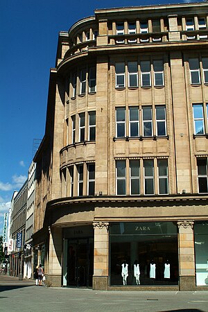
Elsbach & Frank
Former department store in Hanover, Lower Saxony
Distance: Approx. 469 meters
Latitude and longitude: 52.373092,9.737156
Elsbach & Frank was a textile retail business founded in the 19th century in Hanover, the capital of Lower Saxony, Germany. The department store (Kaufhaus) built by the business on the corner of Osterstraße and Große Packhofstraße, called Zum Stern, is the only building in the city centre that survived the air raids on Hanover during the Second World War without major damage. Today, the building houses a branch of the Spanish fashion chain Zara.
Weather in this IP's area
few clouds
27 Celsius
28 Celsius
24 Celsius
28 Celsius
1007 hPa
65 %
1007 hPa
1001 hPa
10000 meters
2.57 m/s
270 degree
20 %
06:44:24
19:53:17