Country:
 Romania
Region:
City:
Latitude and Longitude:
Time Zone:
Postal Code:
IP information under different IP Channel
ip-api
Country
Region
City
ASN
Time Zone
ISP
Blacklist
Proxy
Latitude
Longitude
Postal
Route
IPinfo
Country
Region
City
ASN
Time Zone
ISP
Blacklist
Proxy
Latitude
Longitude
Postal
Route
MaxMind
Country
Region
City
ASN
Time Zone
ISP
Blacklist
Proxy
Latitude
Longitude
Postal
Route
Luminati
Country
RORegion
b
City
sector2
ASN
Time Zone
Europe/Bucharest
ISP
iNES GROUP SRL
Latitude
Longitude
Postal
db-ip
Country
Region
City
ASN
Time Zone
ISP
Blacklist
Proxy
Latitude
Longitude
Postal
Route
ipdata
Country
Region
City
ASN
Time Zone
ISP
Blacklist
Proxy
Latitude
Longitude
Postal
Route
Popular places and events near this IP address

Obor
Square and the surrounding district of Bucharest, the capital of Romania
Distance: Approx. 145 meters
Latitude and longitude: 44.45042222,26.12973056
Obor is the name of a square and the surrounding district of Bucharest, the capital of Romania. There is also a Bucharest Metro station (on the M1 line) named Obor, which lies in this area. The district is near the Colentina and Moșilor neighborhoods.

Obor metro station
Bucharest metro station
Distance: Approx. 335 meters
Latitude and longitude: 44.44991,26.12417
Obor is a metro station in Bucharest, Romania, near one of the city's largest open-air markets, also named Obor. The station, part of the M1 line, originally opened on August 17, 1989, as part of the metro extension from Gara de Nord to Dristor. The station underwent significant refurbishment and was closed for over 10 months, reopening on May 25, 2008.

Piața Iancului metro station
Bucharest metro station
Distance: Approx. 1188 meters
Latitude and longitude: 44.44089,26.13287
Piața Iancului is a metro station in Bucharest. It is located in the Iancului district near the Iulia Hasdeu National College, on the Pache Popescu/Șoseaua Iancului – Șoseaua Mihai Bravu junction. Lines served by STB are 1, 10, 46 and 55 (trams), 135, 311, 330 and 335 (buses).

Foișorul de Foc
Historic building Bucharest, Romania
Distance: Approx. 1329 meters
Latitude and longitude: 44.44033333,26.12058889
Foișorul de Foc (literally The Fire Tower) is a 42 metres (138 feet) high building in Bucharest, Romania, between Obor, Calea Moșilor, and Nerva-Traian. It was used in the past as an observation tower by the firemen. In January 2024, the museum is closed as the building is undergoing restoration, starting from 2021.

Tei, Bucharest
Distance: Approx. 1238 meters
Latitude and longitude: 44.459837,26.118643
Tei is a neighborhood in Sector 2 of Bucharest, Romania. The name comes from the name of a lake in this area: Lacul Tei (Linden Tree Lake). The name of the lake comes from the linden woods that existed around it in the past.

Moșilor
Neighborhood in Bucharest, Romania
Distance: Approx. 1194 meters
Latitude and longitude: 44.442666,26.118643
Moșilor (literally, Elders) is a residential quarter in Bucharest's Sector 2. It houses the Foișorul de Foc and St. Sylvester's Church.

Iancului
District of Bucharest, Romania
Distance: Approx. 1159 meters
Latitude and longitude: 44.441394,26.133728
Iancului is the name of a district in Sector 2 (Bucharest) situated in the northeastern part of Bucharest, the capital of Romania. Piața Iancului is also the name of an intersection in the same district, and has a connection to the Piața Iancului metro station. The name "Iancu" comes from a Romanian revolutionary, Avram Iancu.

Calea Moșilor
Street in Bucharest, Romania
Distance: Approx. 1194 meters
Latitude and longitude: 44.442666,26.118643
Calea Moșilor (Romanian pronunciation: [ˈkale̯a ˈmoʃilor], Moșilor Avenue) is both a historic street and a major road in Bucharest, Romania. It runs from the back of the Cocor Shopping Mall (near Piața Unirii), in Sector 3 to Obor, in Sector 2. The street is divided into two distinct parts.
Iulia Hasdeu National College (Bucharest)
Public high school in Bucharest, Romania
Distance: Approx. 820 meters
Latitude and longitude: 44.44363889,26.12833333
The Iulia Hasdeu National College (Romanian: Colegiul Național Iulia Hasdeu) is a high school located in the eastern part of Bucharest, Romania, right at the crossroad of Ferdinand I Boulevard and Mihai Bravu Highway. It is one of the most prestigious secondary education institutions in Bucharest. It was named after poet Iulia Hasdeu.
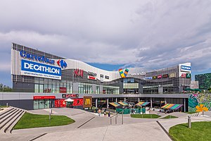
Veranda Mall
Shopping mall
Distance: Approx. 145 meters
Latitude and longitude: 44.450422,26.129731
Veranda Mall is a shopping mall located in Bucharest, Romania, in the Obor neighborhood. It lies on Ziduri Moși Street 23, close to the Obor metro station, and it was inaugurated on October 27, 2016. The shopping mall was developed by Professional Imo Partners SA (formerly known as Prodplast Imobiliare S.A.), following a €60 million investment, and it is currently owned by the Pogonaru family.
Matei Balș hospital fire
2021 fire in Bucharest, Romania
Distance: Approx. 1275 meters
Latitude and longitude: 44.45597222,26.11363889
On 29 January 2021, at around 05:00 EET, a fire broke out at the COVID-19 facility in the Prof. Dr. Matei Balș National Institute for Infectious Diseases in Bucharest, Romania, killing five people.

Mihai Viteazul National College, Bucharest
High school in Bucharest, Romania
Distance: Approx. 1302 meters
Latitude and longitude: 44.4395,26.1251
Mihai Viteazul National College (Romanian: Colegiul Național Mihai Viteazul) is a high school located at 62 Pache Protopopescu Boulevard, Bucharest, Romania. One of the most prestigious secondary education institutions in Romania, it was named after the Romanian ruler Michael the Brave (Romanian: Mihai Viteazul).
Weather in this IP's area
clear sky
28 Celsius
26 Celsius
27 Celsius
29 Celsius
1016 hPa
21 %
1016 hPa
1006 hPa
10000 meters
6.26 m/s
60 degree
06:46:40
19:39:53