80.82.244.102 - IP Lookup: Free IP Address Lookup, Postal Code Lookup, IP Location Lookup, IP ASN, Public IP
Country:
Region:
City:
Location:
Time Zone:
Postal Code:
IP information under different IP Channel
ip-api
Country
Region
City
ASN
Time Zone
ISP
Blacklist
Proxy
Latitude
Longitude
Postal
Route
Luminati
Country
Region
eng
City
witney
ASN
Time Zone
Europe/London
ISP
Public Internet Ltd
Latitude
Longitude
Postal
IPinfo
Country
Region
City
ASN
Time Zone
ISP
Blacklist
Proxy
Latitude
Longitude
Postal
Route
IP2Location
80.82.244.102Country
Region
england
City
witney
Time Zone
Europe/London
ISP
Language
User-Agent
Latitude
Longitude
Postal
db-ip
Country
Region
City
ASN
Time Zone
ISP
Blacklist
Proxy
Latitude
Longitude
Postal
Route
ipdata
Country
Region
City
ASN
Time Zone
ISP
Blacklist
Proxy
Latitude
Longitude
Postal
Route
Popular places and events near this IP address

Witney
English town in West Oxfordshire
Distance: Approx. 511 meters
Latitude and longitude: 51.78,-1.49
Witney is a market town on the River Windrush in West Oxfordshire in the county of Oxfordshire, England. It is 12 miles (19 km) west of Oxford.

West Oxfordshire
Non-metropolitan district in England
Distance: Approx. 1165 meters
Latitude and longitude: 51.79333333,-1.47916667
West Oxfordshire is a local government district in northwest Oxfordshire, England, including towns such as Woodstock, Burford, Chipping Norton, Charlbury, Carterton and Witney, where the council is based.
Wychwood Brewery
English brewery
Distance: Approx. 198 meters
Latitude and longitude: 51.7832,-1.4882
Wychwood Brewery was a brewery and pub chain based in Witney, Oxfordshire, England. the brand is currently owned owned by Carlsberg Marston's. Hobgoblin, a 5.2% abv brown ale, was the company's flagship brand.

Cogges Manor Farm
Former farm in Oxfordshire, England
Distance: Approx. 517 meters
Latitude and longitude: 51.78417,-1.47795
Cogges Manor Farm is a one-time working farm in Cogges near Witney in Oxfordshire, England, now a heritage centre operated by a charitable trust and open to the public.

Cogges
Place in Oxfordshire, England
Distance: Approx. 512 meters
Latitude and longitude: 51.784,-1.478
Cogges is an area beside the River Windrush in Witney, in the West Oxfordshire district, in Oxfordshire, England, 0.5 miles (800 m) east of the town centre. It had been a separate village and until 1932 it was a separate civil parish.

Witney railway station
Former railway station in Oxfordshire, England
Distance: Approx. 707 meters
Latitude and longitude: 51.77725,-1.4854
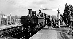
Witney railway station served the Oxfordshire town of Witney on the Oxford, Witney and Fairford Railway line. It consisted of two stone-built platforms, a station building, a signal box, and a shed in the form of a pagoda.
Witney railway station (goods)
Former railway station in Oxfordshire, England
Distance: Approx. 784 meters
Latitude and longitude: 51.77722222,-1.48055556
Witney goods station served the Oxfordshire town of Witney on the Oxford, Witney and Fairford Railway. It consisted of seven sidings, a goods shed, a wooden parcel office and a cattle dock. It also had an engine shed, which was demolished early in the twentieth century.
Robert Boyd Publications
British book publishing company
Distance: Approx. 813 meters
Latitude and longitude: 51.779797,-1.495483
Robert Boyd Publications is a book publishing company based in Witney, Oxfordshire, England. It concentrates on books covering the history of Oxfordshire in general and Oxford in particular, including "The Changing Faces of ..." book series. They have published 70 works between 1994 and 2020.

Witney Town Hall
Municipal building in Witney, Oxfordshire, England
Distance: Approx. 34 meters
Latitude and longitude: 51.7839,-1.4853
Witney Town Hall is a municipal structure in Spring Lane in Market Square, Witney, Oxfordshire, England. The town hall, which is the headquarters of Witney Town Council, is a Grade II* listed building.

Holy Trinity Church, Wood Green
Grade 2 listed Church in Oxfordshire, England
Distance: Approx. 1028 meters
Latitude and longitude: 51.792,-1.4792
Holy Trinity Church, Wood Green, is a Grade II listed Victorian church in Witney, Oxfordshire. The Church was built in 1848–9, on land given by the bishop of Winchester and the duke of Marlborough; the cost was met largely from subscriptions, and a gift from the rector Charles Jerram. The architect was Benjamin Ferrey.
Witney Rural District
District in Oxfordshire, England
Distance: Approx. 1164 meters
Latitude and longitude: 51.7933,-1.4791
Witney Rural District was a rural district in Oxfordshire, England from 1894 to 1974. It surrounded but did not include the town of Witney.

Corn Exchange, Witney
Commercial building in Witney, Oxfordshire, England
Distance: Approx. 85 meters
Latitude and longitude: 51.7843,-1.4849
The Corn Exchange is a commercial building in Market Street, Witney, Oxfordshire, England. The structure, which is used as a public events venue, is a Grade II listed building.
Weather in this IP's area
mist
6 Celsius
5 Celsius
6 Celsius
8 Celsius
1023 hPa
98 %
1023 hPa
1013 hPa
3000 meters
1.54 m/s
250 degree
100 %