Country:
 Russian Federation
Region:
City:
Latitude and Longitude:
Time Zone:
Postal Code:
IP information under different IP Channel
ip-api
Country
Region
City
ASN
Time Zone
ISP
Blacklist
Proxy
Latitude
Longitude
Postal
Route
IPinfo
Country
Region
City
ASN
Time Zone
ISP
Blacklist
Proxy
Latitude
Longitude
Postal
Route
MaxMind
Country
Region
City
ASN
Time Zone
ISP
Blacklist
Proxy
Latitude
Longitude
Postal
Route
Luminati
Country
RUASN
Time Zone
Europe/Moscow
ISP
Joint Stock Company TransTeleCom
Latitude
Longitude
Postal
db-ip
Country
Region
City
ASN
Time Zone
ISP
Blacklist
Proxy
Latitude
Longitude
Postal
Route
ipdata
Country
Region
City
ASN
Time Zone
ISP
Blacklist
Proxy
Latitude
Longitude
Postal
Route
Popular places and events near this IP address
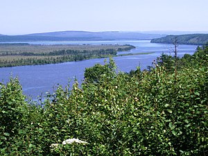
Sovetskaya Gavan
Town in Khabarovsk Krai, Russia
Distance: Approx. 7909 meters
Latitude and longitude: 48.96666667,140.28333333
Sovetskaya Gavan (Russian: Сове́тская Га́вань, lit. 'Soviet harbor') is a town in Khabarovsk Krai, Russia, and a port on the Strait of Tartary which connects the Sea of Okhotsk in the north with the Sea of Japan in the south. Population: 27,712 (2010 Census); 30,480 (2002 Census); 34,915 (1989 Soviet census). It was previously known as Imperatorskaya Gavan (Императорская Гавань, lit.
Vanino, Khabarovsk Krai
Work settlement in Khabarovsk Krai, Russia
Distance: Approx. 8980 meters
Latitude and longitude: 49.08333333,140.26666667
Vanino (Russian: Ва́нино), an urban locality (a work settlement) and the administrative center of Vaninsky District of Khabarovsk Krai, Russia, operates as a port on the Strait of Tartary. Population: 17,001 (2010 Census); 19,180 (2002 Census); 21,510 (1989 Soviet census).

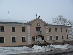
Sovetsko-Gavansky District
District in Khabarovsk Krai, Russia
Distance: Approx. 7905 meters
Latitude and longitude: 48.9667,140.2833
Sovetsko-Gavansky District (Russian: Сове́тско-Га́ванский райо́н) is an administrative and municipal district (raion), one of the seventeen in Khabarovsk Krai, Russia. It is located in the southeast of the krai. The area of the district is 15,534 square kilometers (5,998 sq mi).
Vaninsky District
District in Khabarovsk Krai, Russia
Distance: Approx. 8980 meters
Latitude and longitude: 49.08333333,140.26666667
Vaninsky District (Russian: Ва́нинский райо́н) is an administrative and municipal district (raion), one of the seventeen in Khabarovsk Krai, Russia. It is located in the east of the krai. The area of the district is 25,747 square kilometers (9,941 sq mi).
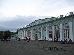
Vanino railway station
Railway station in Russia
Distance: Approx. 9605 meters
Latitude and longitude: 49.08972222,140.26694444
Vanino railway station is a railway station in Vanino, Russia. It includes the building of the railway station and the passenger platform. Tickets of Vanino-Kholmsk train ferry are sold in the station building.
Oktyabrsky, Vaninsky District, Khabarovsk Krai
Urban locality in Khabarovsk Krai, Russia
Distance: Approx. 5971 meters
Latitude and longitude: 49.0625,140.23888889
Oktyabrsky (Russian: Октябрьский) is an urban-type settlement in Vaninsky District, Khabarovsk Krai, Russia. Population: 6,240 (2010 Census); 6,524 (2002 Census); 7,966 (1989 Soviet census). The former Postovaya (air base) is located nearby.
Zavety Ilyicha, Khabarovsk Krai
Urban locality in Khabarovsk Krai, Russia
Distance: Approx. 1744 meters
Latitude and longitude: 49.02472222,140.22083333
Zavety Ilyicha (Russian: Заветы Ильича) is an urban-type settlement in Sovetsko-Gavansky District, Khabarovsk Krai, Russia. Population: 9,162 (2010 Census); 9,429 (2002 Census); 13,141 (1989 Soviet census).
Lososina
Urban locality in Khabarovsk Krai, Russia
Distance: Approx. 8874 meters
Latitude and longitude: 48.99555556,140.32111111
Lososina (Russian: Лососина) is an urban-type settlement in Sovetsko-Gavansky District, Khabarovsk Krai, Russia. Population: 3,224 (2010 Census); 3,246 (2002 Census); 5,687 (1989 Soviet census).
Maysky, Khabarovsk Krai
Urban locality in Khabarovsk Krai, Russia
Distance: Approx. 1767 meters
Latitude and longitude: 48.99861111,140.20666667
Maysky (Russian: Майский) is an urban-type settlement in Sovetsko-Gavansky District, Khabarovsk Krai, Russia. Population: 2,598 (2010 Census); 2,970 (2002 Census); 4,204 (1989 Soviet census).
Postovaya (air base)
Distance: Approx. 2748 meters
Latitude and longitude: 49.03222222,140.22888889
Postovaya (Russian: Постовая) is a former airbase of the Russian Air Force located near Oktyabrsky, Khabarovsk Krai, Russia. The base was home to the 41st Fighter Aviation Regiment between 1943 and 1983 along with the 308th Fighter Aviation Regiment between 1983 and 1994.
Weather in this IP's area
clear sky
13 Celsius
12 Celsius
13 Celsius
13 Celsius
1012 hPa
34 %
1012 hPa
1012 hPa
10000 meters
5.22 m/s
8.2 m/s
291 degree
06:48:48
18:04:25