Country:
 Croatia
Region:
City:
Latitude and Longitude:
Time Zone:
Postal Code:
IP information under different IP Channel
ip-api
Country
Region
City
ASN
Time Zone
ISP
Blacklist
Proxy
Latitude
Longitude
Postal
Route
IPinfo
Country
Region
City
ASN
Time Zone
ISP
Blacklist
Proxy
Latitude
Longitude
Postal
Route
MaxMind
Country
Region
City
ASN
Time Zone
ISP
Blacklist
Proxy
Latitude
Longitude
Postal
Route
Luminati
Country
HRRegion
17
City
sinj
ASN
Time Zone
Europe/Zagreb
ISP
Telemach Hrvatska d.o.o.
Latitude
Longitude
Postal
db-ip
Country
Region
City
ASN
Time Zone
ISP
Blacklist
Proxy
Latitude
Longitude
Postal
Route
ipdata
Country
Region
City
ASN
Time Zone
ISP
Blacklist
Proxy
Latitude
Longitude
Postal
Route
Popular places and events near this IP address

State of Slovenes, Croats and Serbs
1918 unrecognised pan-Slavic state in Southeast Europe
Distance: Approx. 754 meters
Latitude and longitude: 45.8,15.96666667
The State of Slovenes, Croats and Serbs (Serbo-Croatian: Država Slovenaca, Hrvata i Srba / Држава Словенаца, Хрвата и Срба; Slovene: Država Slovencev, Hrvatov in Srbov) was a political entity that was constituted in October 1918, at the end of World War I, by Slovenes, Croats and Serbs (Prečani) residing in what were the southernmost parts of the Austro-Hungarian Empire. Although internationally unrecognised, this was the first incarnation of a Yugoslav state founded on the Pan-Slavic ideology. Thirty-three days after it was proclaimed, the state joined the Kingdom of Serbia to form the Kingdom of Serbs, Croats and Slovenes.

Croatian Radiotelevision
Croatian radio television company
Distance: Approx. 416 meters
Latitude and longitude: 45.79305556,15.97472222
Hrvatska radiotelevizija (abbr. HRT), or Croatian Radiotelevision, is Croatia's public broadcasting company. It operates several radio and television channels, over a domestic transmitter network as well as satellite.
Vjesnik
Croatian daily newspaper (1940-2012)
Distance: Approx. 751 meters
Latitude and longitude: 45.79361111,15.95972222
Vjesnik (lit. 'courier') was a Croatian state-owned daily newspaper published in Zagreb. Originally established in 1940 as a wartime illegal publication of the Communist Party of Croatia, it later built and maintained a reputation as Croatia's newspaper of record during most of its post-war history. It ceased publication in April 2012.

Kingdom of Croatia-Slavonia
Territory within Austria-Hungary
Distance: Approx. 754 meters
Latitude and longitude: 45.8,15.96666667
The Kingdom of Croatia-Slavonia (Croatian: Kraljevina Hrvatska i Slavonija; Hungarian: Horvát-Szlavónország or Horvát–Szlavón Királyság; German: Königreich Kroatien und Slawonien) was a nominally autonomous kingdom and constitutionally defined separate political nation within the Austro-Hungarian Empire. It was created in 1868 by merging the kingdoms of Croatia and Slavonia following the Croatian–Hungarian Settlement of 1868. It was associated with the Kingdom of Hungary within the dual Austro-Hungarian state, being within the Lands of the Crown of St.
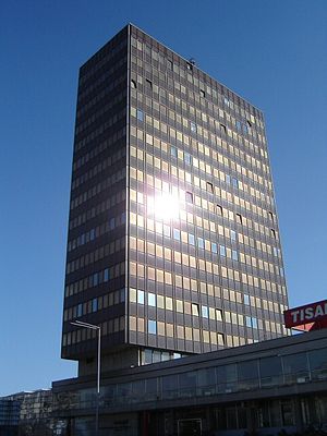
Eurotower (Zagreb)
Building in Zagreb, Croatia
Distance: Approx. 591 meters
Latitude and longitude: 45.79881,15.96945
Eurotower is a high-rise building in Zagreb, Croatia, located in Trnje at the intersection of the Vukovarska and Lučićeva streets, in the southwest corner. It was built in 2006. This office tower has 26 levels and it is 96 m (315 ft) tall.

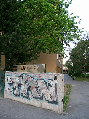
University Computing Centre
Distance: Approx. 111 meters
Latitude and longitude: 45.7925,15.96944444
The University Computing Centre in Zagreb (Croatian: Sveučilišni računski centar, abbreviated SRCE, which also means "heart") has a long tradition in the area of information and communication technologies. It was founded in 1971 within the University of Zagreb, the only Croatian university at the time, with the purpose to enhance the implementation of information technologies in the academic community as well as in Croatia in general. Today, SRCE is the main computing centre and the architect of the e-infrastructure, covering both the University of Zagreb and the whole research and high education system.

National and University Library in Zagreb
National library of Croatia and central library of the University of Zagreb
Distance: Approx. 721 meters
Latitude and longitude: 45.79666667,15.9775
National and University Library in Zagreb (NSK) (Croatian: Nacionalna i sveučilišna knjižnica u Zagrebu, NSK; formerly Nacionalna i sveučilišna biblioteka u Zagrebu, NSB) is the national library of Croatia and central library of the University of Zagreb. The Library was established in 1607. Its primary mission is the development and preservation of Croatian national written heritage.
Faculty of Teacher Education, University of Zagreb
Distance: Approx. 699 meters
Latitude and longitude: 45.797066,15.961981
The Faculty of Teacher Education at the University of Zagreb is a faculty which focusses on the education of teachers and preschool teachers. Apart from its central location in Zagreb, it has facilities in Petrinja and Čakovec. The first teacher's school in Zagreb was the Higher Pedagogical School which offered a two-year program from 1919.
Faculty of Humanities and Social Sciences, University of Zagreb
University department
Distance: Approx. 381 meters
Latitude and longitude: 45.79673,15.97104
The Faculty of Humanities and Social Sciences or the Faculty of Philosophy in Zagreb (Croatian: Filozofski fakultet Sveučilišta u Zagrebu) is one of the faculties of the University of Zagreb.

Ministry of Tourism and Sports (Croatia)
Ministry in the Government of Croatia
Distance: Approx. 259 meters
Latitude and longitude: 45.791182,15.96911
The Ministry of Tourism and Sports (Croatian: Ministarstvo turizma i sporta) is the ministry in the Government of Croatia which in charge of the development of tourism.
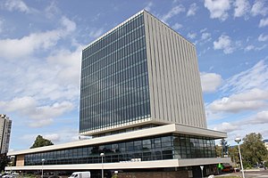
Kockica
Building in Zagreb
Distance: Approx. 318 meters
Latitude and longitude: 45.79066667,15.96883333
Kockica (a diminutive form of "kocka", Croatian for "Dice" or "Little Cube") is a 10-story mixed-use building located at Prisavlje 14 in Zagreb, the capital of Croatia. It was originally built to house the Central Committee of the League of Communists of Croatia and currently serves as the headquarters of Ministry of Maritime Affairs, Transport and Infrastructure and Ministry of Tourism of Croatia. Croatian architect Ivan Vitić planned the building, the construction of which began in 1963.
XI Gymnasium
Grammar school in Zagreb, Croatia
Distance: Approx. 711 meters
Latitude and longitude: 45.79732,15.96206
The Eleventh Gymnasium (Croatian: Jedanaesta gimnazija) is a public secondary school in Zagreb, Croatia, established in 1926. The school, as of 2021, has 465 students enrolled, and 16 classes. The principal is Maja Sečić-Kopinč.
Weather in this IP's area
clear sky
17 Celsius
16 Celsius
15 Celsius
17 Celsius
1019 hPa
77 %
1019 hPa
1006 hPa
10000 meters
2.06 m/s
50 degree
06:40:52
18:58:10