80.78.211.126 - IP Lookup: Free IP Address Lookup, Postal Code Lookup, IP Location Lookup, IP ASN, Public IP
Country:
Region:
City:
Location:
Time Zone:
Postal Code:
ISP:
ASN:
language:
User-Agent:
Proxy IP:
Blacklist:
IP information under different IP Channel
ip-api
Country
Region
City
ASN
Time Zone
ISP
Blacklist
Proxy
Latitude
Longitude
Postal
Route
db-ip
Country
Region
City
ASN
Time Zone
ISP
Blacklist
Proxy
Latitude
Longitude
Postal
Route
IPinfo
Country
Region
City
ASN
Time Zone
ISP
Blacklist
Proxy
Latitude
Longitude
Postal
Route
IP2Location
80.78.211.126Country
Region
kalmar lan
City
kalmar
Time Zone
Europe/Stockholm
ISP
Language
User-Agent
Latitude
Longitude
Postal
ipdata
Country
Region
City
ASN
Time Zone
ISP
Blacklist
Proxy
Latitude
Longitude
Postal
Route
Popular places and events near this IP address

Kalmar Municipality
Municipality in Kalmar County, Sweden
Distance: Approx. 644 meters
Latitude and longitude: 56.66666667,16.36666667
Kalmar Municipality (Kalmar kommun) is a municipality in Kalmar County, southeastern Sweden. The city of Kalmar is the municipal seat. The present municipality was created in 1971, when the City of Kalmar was amalgamated with five surrounding rural municipalities.

Kalmar
City in Småland, Sweden
Distance: Approx. 76 meters
Latitude and longitude: 56.66138889,16.36277778
Kalmar (, US also , Swedish: [ˈkǎlmar] ) is a city in the southeast of Sweden, situated by the Baltic Sea. It had 41,388 inhabitants in 2020 and is the seat of Kalmar Municipality. It is also the capital of Kalmar County, which comprises 12 municipalities with a total of 236,399 inhabitants (2015).

Kalmar Castle
Historic site in Småland, Sweden
Distance: Approx. 569 meters
Latitude and longitude: 56.658,16.355
Kalmar Castle (Swedish: Kalmar slott) is a castle in the city Kalmar in the province of Småland in Sweden.

Diocese of Kalmar
Distance: Approx. 477 meters
Latitude and longitude: 56.66472222,16.36694444
The Diocese of Kalmar (Swedish: Kalmar stift) was a division of the Church of Sweden between 1603 and 1915, when it was merged into the diocese of Växjö in order to allow the new diocese of Luleå to be formed. It was created as a subdivision to the diocese of Linköping, and was under the supervision of a superintendent. Only in 1678 was a bishop appointed, and Kalmar cathedral became an episcopal see in the term proper.

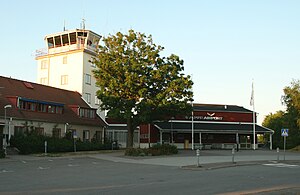
Kalmar Airport
Airport in Kalmar
Distance: Approx. 5243 meters
Latitude and longitude: 56.68527778,16.2875
Kalmar Airport (IATA: KLR, ICAO: ESMQ), branded as Kalmar Öland Airport, is an airport in south-eastern Sweden. The airport is located 5 kilometres west of downtown Kalmar. The airfield was originally the home of the Kalmar Wing (F 12).

Fredriksskans
Sports venue in Kalmar, Sweden
Distance: Approx. 782 meters
Latitude and longitude: 56.66861111,16.36083333
Fredriksskans is a multi-purpose stadium in Kalmar, Sweden. It served as the home ground for Kalmar FF until it was replaced by Guldfågeln Arena in 2011. It is used for football matches and athletics.

Kalmar Cathedral
Church in Kalmar, Sweden
Distance: Approx. 388 meters
Latitude and longitude: 56.66444444,16.36527778
Kalmar Cathedral (Swedish: Kalmar domkyrka) is in the city of Kalmar in Småland in southeast Sweden. Located in Stortorget Square, construction began in 1660. The Cathedral was designed for the Church of Sweden by architect Nicodemus Tessin.

Kalmar Wing
Military unit
Distance: Approx. 4909 meters
Latitude and longitude: 56.6761,16.2858
Kalmar Wing (Swedish: Kalmar flygflottilj), also F 12 Kalmar, or simply F 12, is a former Swedish Air Force wing with the main base located on the south-east coast of Sweden.

Ironman Sweden
Distance: Approx. 719 meters
Latitude and longitude: 56.66611111,16.37
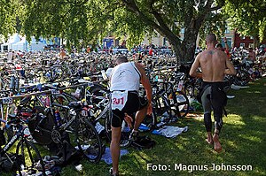
Ironman Sweden, also known as Ironman Kalmar or the Kalmar Triathlon, is an Ironman triathlon held in Kalmar, Sweden. It is the only Ironman-branded iron distance event in Sweden and also serves as the Swedish national championship. The distance is the same as other Ironman triathlons races: 3.86 kilometres (2.40 mi) open water swimming, 180 kilometres (110 mi) cycling and a 42.2-kilometre (26.2 mi) marathon.
Boholmarna
Place in Småland, Sweden
Distance: Approx. 3984 meters
Latitude and longitude: 56.65,16.3
Boholmarna is a locality situated in Kalmar Municipality, Kalmar County, Sweden with 297 inhabitants in 2010. It consists of several islands.
Dunö
Place in Småland, Sweden
Distance: Approx. 6607 meters
Latitude and longitude: 56.63333333,16.26666667
Dunö is a locality situated in Kalmar Municipality, Kalmar County, Sweden with 384 inhabitants as of 2010.
Rinkabyholm
Place in Småland, Sweden
Distance: Approx. 5951 meters
Latitude and longitude: 56.65,16.26666667
Rinkabyholm is a locality situated in Kalmar Municipality, Kalmar County, Sweden with 1,607 inhabitants in 2010.
Weather in this IP's area
overcast clouds
1 Celsius
-2 Celsius
1 Celsius
2 Celsius
1018 hPa
100 %
1018 hPa
1016 hPa
7000 meters
3.09 m/s
100 degree
100 %