80.76.9.251 - IP Lookup: Free IP Address Lookup, Postal Code Lookup, IP Location Lookup, IP ASN, Public IP
Country:
Region:
City:
Location:
Time Zone:
Postal Code:
IP information under different IP Channel
ip-api
Country
Region
City
ASN
Time Zone
ISP
Blacklist
Proxy
Latitude
Longitude
Postal
Route
Luminati
Country
ASN
Time Zone
Europe/Madrid
ISP
TELXIUS TELXIUS Cable
Latitude
Longitude
Postal
IPinfo
Country
Region
City
ASN
Time Zone
ISP
Blacklist
Proxy
Latitude
Longitude
Postal
Route
IP2Location
80.76.9.251Country
Region
andalucia
City
ronda
Time Zone
Europe/Madrid
ISP
Language
User-Agent
Latitude
Longitude
Postal
db-ip
Country
Region
City
ASN
Time Zone
ISP
Blacklist
Proxy
Latitude
Longitude
Postal
Route
ipdata
Country
Region
City
ASN
Time Zone
ISP
Blacklist
Proxy
Latitude
Longitude
Postal
Route
Popular places and events near this IP address

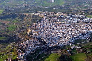
Ronda
Municipality in Andalusia, Spain
Distance: Approx. 604 meters
Latitude and longitude: 36.73722222,-5.16472222
Ronda (Spanish pronunciation: [ˈronda]) is a municipality of Spain belonging to the province of Málaga, within the autonomous community of Andalusia. Its population is about 35,000. Ronda is known for its cliffside location and a deep canyon that carries the Guadalevín River and divides the town.
Puente Viejo
Bridge in Ronda
Distance: Approx. 444 meters
Latitude and longitude: 36.739722,-5.163303
Puente Viejo (Spanish pronunciation: [ˈpwente ˈβjexo], "Old Bridge") is the second oldest and second lowest of the three bridges that span the 120-metre (390 ft) deep chasm that carries the Guadalevín River and divides the city of Ronda in southern Spain. Despite its name ('Old bridge'), it is newer than the Puente Romano ('Roman bridge'). It was built in 1616, and currently only carries pedestrian traffic.

Puente Nuevo
Bridge in Ronda
Distance: Approx. 203 meters
Latitude and longitude: 36.74074722,-5.16590278
The Puente Nuevo (Spanish pronunciation: [ˈpwente ˈnweβo], "New Bridge") is the newest and largest of three bridges that span the 120-metre-deep (390 ft) chasm that carries the Guadalevín River and divides the city of Ronda, in southern Spain. Completed in 1793, the architect was José Martin de Aldehuela and the chief builder was Juan Antonio Díaz Machuca. The construction of the newest bridge (the one standing as of 2024) was started in 1759 and took 34 years.

Plaza de Toros de Ronda
Bullring in Ronda, Spain
Distance: Approx. 7 meters
Latitude and longitude: 36.742361,-5.167067
The Plaza de Toros de Ronda is a Bullring in Ronda, it has a diameter of 66 metres (217 ft), surrounded by a passage formed by two rings of stone. There are two layers of seating, each with five raised rows and 136 pillars that make up 68 arches. The Royal Box has a sloping roof covered in Arabic tiles.

Arriate
Municipality in Andalusia, Spain
Distance: Approx. 6750 meters
Latitude and longitude: 36.79916667,-5.14083333
Arriate is a town and municipality in the Province of Málaga, part of the autonomous community of Andalusia in southern Spain. The municipality is situated approximately 120 kilometres (75 mi) from Malaga capital. It has a population of approximately 3600 residents.

Montejaque
Place in Andalusia, Spain
Distance: Approx. 9330 meters
Latitude and longitude: 36.71666667,-5.26666667
Montejaque is a town and municipality in the province of Málaga, part of the autonomous community of Andalusia in southern Spain. It belongs to the comarca of Serranía de Ronda. The municipality is situated approximately 125 kilometres from the city of Málaga, 21 from Ronda and only 2 from Benaoján.

Guadalevín
River in Spain
Distance: Approx. 271 meters
Latitude and longitude: 36.739975,-5.16801667
The Guadalevín is a tributary of the river Guadiaro in Málaga, Andalusia, Spain. Its gorge divides the city of Ronda where it is spanned by three bridges, Puente Nuevo, Puente Viejo and Puente Romano. The following is a translation of the Spanish Wikipedia article on the Guadalevin.

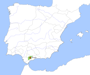
Taifa of Ronda
Distance: Approx. 1003 meters
Latitude and longitude: 36.7333,-5.1667
The Taifa of Ronda (Arabic: طائفة رندة) was a medieval Berber taifa kingdom centered in Moorish al-Andalus in what is now southern Spain. It existed from 1039 to 1065. The taifa was ruled by a family from the Berber Banu Ifran tribe of North Africa.
Autovía A-374
Distance: Approx. 6510 meters
Latitude and longitude: 36.7743,-5.2282
The Autovía A-374 is a highway in Spain. It passes through Andalusia between the provinces of Cádiz and Málaga.
Presa de Montejaque
Distance: Approx. 6604 meters
Latitude and longitude: 36.75357,-5.23979
Presa de Montejaque was a reservoir in the province of Málaga, Andalusia, Spain.
Weather in this IP's area
clear sky
10 Celsius
9 Celsius
10 Celsius
10 Celsius
1028 hPa
63 %
1028 hPa
945 hPa
10000 meters
1.82 m/s
2.83 m/s
132 degree
2 %
