80.75.220.166 - IP Lookup: Free IP Address Lookup, Postal Code Lookup, IP Location Lookup, IP ASN, Public IP
Country:
 Germany
Region:
City:
Location:
Time Zone:
Postal Code:
ISP:
ASN:
language:
User-Agent:
Proxy IP:
Blacklist:
IP information under different IP Channel
ip-api
Country
Region
City
ASN
Time Zone
ISP
Blacklist
Proxy
Latitude
Longitude
Postal
Route
db-ip
Country
Region
City
ASN
Time Zone
ISP
Blacklist
Proxy
Latitude
Longitude
Postal
Route
IPinfo
Country
Region
City
ASN
Time Zone
ISP
Blacklist
Proxy
Latitude
Longitude
Postal
Route
IP2Location
80.75.220.166Country
deRegion
rheinland-pfalz
City
rorodt
Time Zone
ISP
Language
User-Agent
Latitude
Longitude
Postal
ipdata
Country
Region
City
ASN
Time Zone
ISP
Blacklist
Proxy
Latitude
Longitude
Postal
Route
Popular places and events near this IP address
Thalfang
Municipality in Rhineland-Palatinate, Germany
Distance: Approx. 4021 meters
Latitude and longitude: 49.75583333,6.99666667
The climatic spa (Luftkurort) of Thalfang is an Ortsgemeinde – a municipality belonging to a Verbandsgemeinde, a kind of collective municipality – in the Bernkastel-Wittlich district in Rhineland-Palatinate, Germany. It is the seat of the Verbandsgemeinde of Thalfang am Erbeskopf.

Deuselbach
Municipality in Rhineland-Palatinate, Germany
Distance: Approx. 1612 meters
Latitude and longitude: 49.75222222,7.05055556
Deuselbach is an Ortsgemeinde – a municipality belonging to a Verbandsgemeinde, a kind of collective municipality – in the Bernkastel-Wittlich district in Rhineland-Palatinate, Germany.
Etgert
Municipality in Rhineland-Palatinate, Germany
Distance: Approx. 2466 meters
Latitude and longitude: 49.77944444,7.02194444
Etgert is an Ortsgemeinde – a municipality belonging to a Verbandsgemeinde, a kind of collective municipality – in the Bernkastel-Wittlich district in Rhineland-Palatinate, Germany.

Gielert
Municipality in Rhineland-Palatinate, Germany
Distance: Approx. 3515 meters
Latitude and longitude: 49.77456667,7.00264444
Gielert is an Ortsgemeinde – a municipality belonging to a Verbandsgemeinde, a kind of collective municipality – in the Bernkastel-Wittlich district in Rhineland-Palatinate, Germany.

Gräfendhron
Municipality in Rhineland-Palatinate, Germany
Distance: Approx. 5037 meters
Latitude and longitude: 49.79342222,6.99345278
Gräfendhron is an Ortsgemeinde – a municipality belonging to a Verbandsgemeinde, a kind of collective municipality – in the Bernkastel-Wittlich district in Rhineland-Palatinate, Germany.

Hilscheid
Municipality in Rhineland-Palatinate, Germany
Distance: Approx. 5030 meters
Latitude and longitude: 49.73170833,7.00575
Hilscheid is an Ortsgemeinde – a municipality belonging to a Verbandsgemeinde, a kind of collective municipality – in the Bernkastel-Wittlich district in Rhineland-Palatinate, Germany.

Immert
Municipality in Rhineland-Palatinate, Germany
Distance: Approx. 2143 meters
Latitude and longitude: 49.76527778,7.02027778
Immert is an Ortsgemeinde – a municipality belonging to a Verbandsgemeinde, a kind of collective municipality – in the Bernkastel-Wittlich district in Rhineland-Palatinate, Germany.

Merschbach
Municipality in Rhineland-Palatinate, Germany
Distance: Approx. 5180 meters
Latitude and longitude: 49.80333333,7.00555556
Merschbach is an Ortsgemeinde – a municipality belonging to a Verbandsgemeinde, a kind of collective municipality – in the Bernkastel-Wittlich district in Rhineland-Palatinate, Germany.

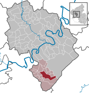
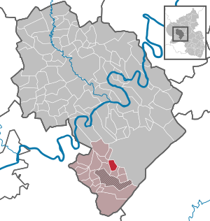
Rorodt
Municipality in Rhineland-Palatinate, Germany
Distance: Approx. 346 meters
Latitude and longitude: 49.76972222,7.05111111
Rorodt is an Ortsgemeinde – a municipality belonging to a Verbandsgemeinde, a kind of collective municipality – in the Bernkastel-Wittlich district in Rhineland-Palatinate, Germany.

Thalfang am Erbeskopf
Distance: Approx. 4021 meters
Latitude and longitude: 49.75583333,6.99666667
Thalfang am Erbeskopf is a Verbandsgemeinde ("collective municipality") in the district Bernkastel-Wittlich, in Rhineland-Palatinate, Germany. Its seat of administration is in Thalfang.

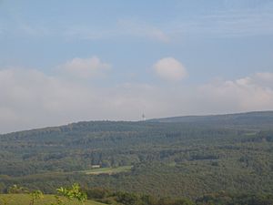
Erbeskopf
Mountain in southwest Germany
Distance: Approx. 4983 meters
Latitude and longitude: 49.730444,7.090639
The Erbeskopf () is a mountain in the Hunsrück range in central Germany. At a height of 816 metres (2,677 ft), it is the highest point in the state of Rhineland-Palatinate, as well as the highest point of German territory on the western bank of the Rhine. It lies within the Saar-Hunsrück Nature Park.
Kahlheid
Distance: Approx. 5022 meters
Latitude and longitude: 49.748,7.113556
The Kahlheid near Morscheid-Riedenburg in the Idar Forest (Hunsrück) is a mountain, 766 m above sea level (NHN), on the boundary between the counties of Birkenfeld and Bernkastel-Wittlich in the German state of Rhineland-Palatinate. The mountain is the third highest in Rhineland-Palatinate after the Erbeskopf (816.3 m), 2.6 km to the southwest and its southwestern subpeak, the Springenkopf (784.2 m), in the Schwarzwälder Hochwald, and the peak of An den zwei Steinen (766.2 m), 12 km to the northeast (both distances as the crow flies), also in the Idar Forest.
Weather in this IP's area
clear sky
-5 Celsius
-7 Celsius
-5 Celsius
-4 Celsius
1026 hPa
83 %
1026 hPa
965 hPa
10000 meters
1.6 m/s
1.38 m/s
82 degree
6 %