Country:
 Finland
Region:
City:
Latitude and Longitude:
Time Zone:
Postal Code:
IP information under different IP Channel
ip-api
Country
Region
City
ASN
Time Zone
ISP
Blacklist
Proxy
Latitude
Longitude
Postal
Route
IPinfo
Country
Region
City
ASN
Time Zone
ISP
Blacklist
Proxy
Latitude
Longitude
Postal
Route
MaxMind
Country
Region
City
ASN
Time Zone
ISP
Blacklist
Proxy
Latitude
Longitude
Postal
Route
Luminati
Country
FIRegion
14
City
oulu
ASN
Time Zone
Europe/Helsinki
ISP
Cinia Oy
Latitude
Longitude
Postal
db-ip
Country
Region
City
ASN
Time Zone
ISP
Blacklist
Proxy
Latitude
Longitude
Postal
Route
ipdata
Country
Region
City
ASN
Time Zone
ISP
Blacklist
Proxy
Latitude
Longitude
Postal
Route
Popular places and events near this IP address

University of Oulu
University in Oulu, Finland
Distance: Approx. 1131 meters
Latitude and longitude: 65.05916667,25.46611111
The University of Oulu (Finnish: Oulun yliopisto) is one of the largest universities in Finland, located in the city of Oulu. It was founded on July 8, 1958. The university has around 13,000 students and 2,900 staff.

Oulu University of Applied Sciences
Polytechnic university in Northern Ostrobothnia, Finland
Distance: Approx. 1201 meters
Latitude and longitude: 65.061295,25.467637
Oulu University of Applied Sciences (OAMK) (Finnish: Oulun ammattikorkeakoulu) is a university of applied sciences in Oulu, Finland, with approximately 9,000 students, including around 240 international degree students. The number of incoming exchange students annually is approximately 280.

Villa Hannala
Distance: Approx. 3623 meters
Latitude and longitude: 65.02972222,25.4375
Villa Hannala is a historic villa in Toppilansaari, Oulu, Finland. Located at Kahvelitie 1, the villa was built in 1859 for the Snellman family. Decorations and a tower were added in the 1890s.

Toppila Power Station
Power plant in Oulu, Finland
Distance: Approx. 3048 meters
Latitude and longitude: 65.03777778,25.43611111
The Toppila Power Station is a power station in the Toppila district in Oulu, Finland. As of 2019 it is one of the largest peat-fired power stations in the world, with an installed capacity of 210 MW of electric power and 340 MW of thermal power. The facility operates two units of 75 MWe and 145 MWe.
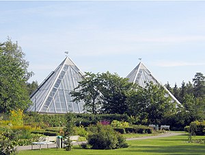
University of Oulu Botanical Gardens
Botanical garden in Oulu, Finland
Distance: Approx. 1413 meters
Latitude and longitude: 65.06305556,25.46527778
The Botanical Garden of the University of Oulu is one of the northernmost scientific gardens in the world. Botanical Garden collection of plants is maintained for teaching and research purposes and it is open to the public. Collections include more than 4,000 different plant species and provide an overview of global vegetation diversity.
Tuira Church
Church in Oulu, Finland
Distance: Approx. 3380 meters
Latitude and longitude: 65.02444444,25.47722222
The Tuira Church (Finnish: Tuiran kirkko) is an evangelical Lutheran church in Tuira, Oulu. The church building has been designed by architect Harald Andersin and it was inaugurated as a chapel of Oulu parish in 1916. The parish of Oulu was divided into smaller parishes in 1966 and the chapel in Tuira was inaugurated as a church.

Tuira, Oulu
District of Oulu in Finland
Distance: Approx. 3266 meters
Latitude and longitude: 65.026,25.471
Tuira is a district of the city of Oulu, Finland. It is located north of city centre across the Oulujoki River. After the first bridges over Oulujoki connecting Tuira with Oulu were built in 1869, population growth of Tuira accelerated and Tuira was annexed by city of Oulu from the neighbouring rural municipality in 1886.

Koskikeskus
District of Oulu in Finland
Distance: Approx. 3903 meters
Latitude and longitude: 65.02055556,25.46666667
Koskikeskus (literally Rapids Center in Finnish) is a neighbourhood in the Tuira area in the city of Oulu, Finland. The neighbourhood is located in the estuary of the river Oulujoki. The Tuira Bridges in Koskikeskus connect the city centre and Tuira neighbourhoods.

Merikoski Power Plant
Dam in Oulu
Distance: Approx. 3593 meters
Latitude and longitude: 65.02277778,25.47333333
Merikoski Power Plant is a hydroelectric power station and a dam in the Koskikeskus district in Oulu, Finland. The plant is owned by the Oulun Energia municipal enterprise of the city of Oulu. Construction of the power plant was started in 1940, but electricity generation for national grid was not started until 1948.

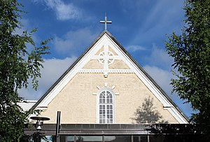
St. Luke's Chapel, Oulu
Church in Oulu, Finland
Distance: Approx. 983 meters
Latitude and longitude: 65.06027778,25.47166667
St. Luke's Chapel is an evangelical Lutheran church in the University of Oulu Linnanmaa campus in Oulu. The opening service of the academic year is held at St.

Holy Family of Nazareth Church, Oulu
Church in Oulu, Finland
Distance: Approx. 1853 meters
Latitude and longitude: 65.04472222,25.45555556
The Holy Family of Nazareth Church (Finnish: Nasaretin pyhän perheen kirkko) is a Roman Catholic church in the Koskela district in Oulu. The church building, designed by architect Gabriel Geronzi, was constructed in two phases. Pope John Paul II blessed the cornerstone of the church on his visit to Finland in 1989.
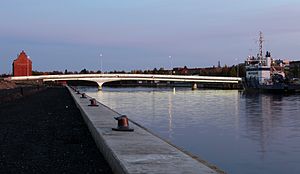
Möljä Bridge
Bridge in Oulu, Finland
Distance: Approx. 3545 meters
Latitude and longitude: 65.03333333,25.43111111
The Möljä Bridge (Finnish: Möljän silta) is a concrete beam bridge over the Toppilansalmi strait in Oulu, Finland. The bridge connects districts of Toppila and Toppilansaari. The bridge is 98 metres (322 ft) long, about 20 metres longer than the width of the Toppilansalmi strait at that point.
Weather in this IP's area
clear sky
16 Celsius
16 Celsius
16 Celsius
16 Celsius
1023 hPa
100 %
1023 hPa
1021 hPa
10000 meters
5.66 m/s
280 degree
06:55:22
19:27:33