Country:
 Germany
Region:
City:
Latitude and Longitude:
Time Zone:
Postal Code:
IP information under different IP Channel
ip-api
Country
Region
City
ASN
Time Zone
ISP
Blacklist
Proxy
Latitude
Longitude
Postal
Route
IPinfo
Country
Region
City
ASN
Time Zone
ISP
Blacklist
Proxy
Latitude
Longitude
Postal
Route
MaxMind
Country
Region
City
ASN
Time Zone
ISP
Blacklist
Proxy
Latitude
Longitude
Postal
Route
Luminati
Country
DERegion
he
City
gravenwiesbach
ASN
Time Zone
Europe/Berlin
ISP
true global communications GmbH
Latitude
Longitude
Postal
db-ip
Country
Region
City
ASN
Time Zone
ISP
Blacklist
Proxy
Latitude
Longitude
Postal
Route
ipdata
Country
Region
City
ASN
Time Zone
ISP
Blacklist
Proxy
Latitude
Longitude
Postal
Route
Popular places and events near this IP address

Grävenwiesbach
Municipality in Hesse, Germany
Distance: Approx. 889 meters
Latitude and longitude: 50.38583333,8.45666667
Grävenwiesbach is a municipality in the Hochtaunuskreis in Hesse, Germany.

Waldsolms
Municipality in Hesse, Germany
Distance: Approx. 4909 meters
Latitude and longitude: 50.41666667,8.51666667
Waldsolms is a municipality located in the Lahn-Dill-Kreis in Hesse, Germany.

Weilrod
Municipality in Hesse, Germany
Distance: Approx. 7329 meters
Latitude and longitude: 50.33333333,8.41666667
Weilrod is a municipality made up of several villages in the northwest Hochtaunuskreis lying in the Weil Valley in Hesse, Germany.
Hühnerküppel
Distance: Approx. 7307 meters
Latitude and longitude: 50.40305556,8.35555556
Hühnerküppel is a hill of Hesse, Germany.
Eschbach (Usingen)
Borough of Usingen in Hesse, Germany
Distance: Approx. 6975 meters
Latitude and longitude: 50.3569,8.5369
Eschbach is a borough of Usingen in the Hochtaunuskreis in Hessen. The once almost entirely agriculturally based village at the northern edge of the Usinger Becken first appeared in 1280 in the County Cleeberg under the name of Ketteneschbach. The current district of Usingen was known far beyond the Taunus already early through good catering, later through the campsite in the forest and the former weekend-settlement below the Eschbacher Klippen.
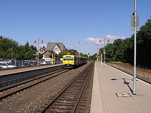
Grävenwiesbach station
Railway station in Grävenwiesbach, Germany
Distance: Approx. 1278 meters
Latitude and longitude: 50.38233,8.45837
Grävenwiesbach station is the station of Grävenwiesbach on the edge of the Hochtaunuskreis in the German state of Hesse. It is located on the southern outskirts of the town centre. Previously, the station was a junction station that served trains running on the Weil Valley Railway to Weilburg via Weilmünster, on the Taunus Railway to Bad Homburg and on the Solms Valley Railway to Wetzlar.
Wiesbach (Weil)
River in Germany
Distance: Approx. 4826 meters
Latitude and longitude: 50.4045,8.3916
Wiesbach is a river of Hesse, Germany. The Wiesbach springs between Hundstadt, a district of Grävenwiesbach, and Michelbach , a district of Usingen. It is a right tributary of the Weil before Audenschmiede, a district of Weilmünster.
Wiesbach (Rott)
River in Germany
Distance: Approx. 4826 meters
Latitude and longitude: 50.4045,8.3916
Wiesbach is a river of Bavaria, Germany. The Wiesbach springs near Frauenhaselbach, a district of Neumarkt-Sankt Veit). It is a left tributary of the Rott near the district Hörbering of Neumarkt-Sankt Veit.

Langenbach (Weilmünster)
Village of Weilmünster in Hesse, Germany
Distance: Approx. 5775 meters
Latitude and longitude: 50.39805556,8.37638889
Langenbach is a village (Ortsteil) of the municipality of Weilmünster in the district of Limburg-Weilburg in central Hesse, Germany. It has around 370 inhabitants (2021).
Dietenhausen
Village of Weilmünster in Hesse, Germany
Distance: Approx. 3837 meters
Latitude and longitude: 50.42305556,8.42888889
Dietenhausen is a village (Ortsteil) of the municipality of Weilmünster in the district of Limburg-Weilburg in central Hesse. It has around 400 inhabitants (2021).

Rohnstadt
Village of Weilmünster in Hesse, Germany
Distance: Approx. 7033 meters
Latitude and longitude: 50.40611111,8.36027778
Rohnstadt is a village (Ortsteil) of the municipality of Weilmünster in the district of Limburg-Weilburg in central Hesse. It has around 260 inhabitants (2021).

Kirbergturm
Building in Hesse, Germany
Distance: Approx. 7298 meters
Latitude and longitude: 50.43104,8.37283
The Kirbergturm (Kirberg Tower), also known as the Römerturm (Roman Tower), is a stone watchtower that is a listed building. It is located in the historic market town of Weilmünster in Hesse. The tower, which is almost 20 meters high, is located in the town center on the Kirberg hill (formerly known as Römerberg).
Weather in this IP's area
overcast clouds
14 Celsius
14 Celsius
13 Celsius
15 Celsius
1020 hPa
91 %
1020 hPa
981 hPa
10000 meters
1.66 m/s
2.28 m/s
193 degree
100 %
07:55:21
18:26:28