Country:
 Germany
Region:
City:
Latitude and Longitude:
Time Zone:
Postal Code:
IP information under different IP Channel
ip-api
Country
Region
City
ASN
Time Zone
ISP
Blacklist
Proxy
Latitude
Longitude
Postal
Route
IPinfo
Country
Region
City
ASN
Time Zone
ISP
Blacklist
Proxy
Latitude
Longitude
Postal
Route
MaxMind
Country
Region
City
ASN
Time Zone
ISP
Blacklist
Proxy
Latitude
Longitude
Postal
Route
Luminati
Country
DEASN
Time Zone
Europe/Berlin
ISP
true global communications GmbH
Latitude
Longitude
Postal
db-ip
Country
Region
City
ASN
Time Zone
ISP
Blacklist
Proxy
Latitude
Longitude
Postal
Route
ipdata
Country
Region
City
ASN
Time Zone
ISP
Blacklist
Proxy
Latitude
Longitude
Postal
Route
Popular places and events near this IP address

Oberursel (Taunus)
Town in Hesse, Germany
Distance: Approx. 2103 meters
Latitude and longitude: 50.20333333,8.57694444
Oberursel (Taunus) (German: [oː.bɐ.ˈʊʁ.zl̩] ) is a town in Germany and part of the Frankfurt Rhein-Main urban area. It is located to the north west of Frankfurt, in the Hochtaunuskreis county. It is the 13th largest town in Hesse.

Bad Homburg
Town in Hesse, Germany
Distance: Approx. 3354 meters
Latitude and longitude: 50.21666667,8.6
Bad Homburg vor der Höhe (German pronunciation: [baːt ˈhɔmbʊʁk] ) is the district town of the Hochtaunuskreis, Hesse, Germany, on the southern slope of the Taunus mountains. Bad Homburg is part of the Frankfurt Rhein-Main urban area. The town's official name is Bad Homburg v.d.Höhe, which distinguishes it from other places named Homburg.

Weißkirchen radio transmitter
Distance: Approx. 1469 meters
Latitude and longitude: 50.18375,8.61175
The transmitter Weißkirchen was a medium wave broadcasting facility located near Weißkirchen, Oberursel, Germany. It was the most powerful European AM transmitter of the American Forces Network and transmitted on 873 kHz with a power of 150 kilowatts. It started operation in May 1951 on 872 kHz and moved its frequency to 873 kHz in 1978 according to the regulations of Waveplan of Geneva.
Motorenfabrik Oberursel
Distance: Approx. 3307 meters
Latitude and longitude: 50.21138889,8.56527778
Motorenfabrik Oberursel A.G. was a German manufacturer of automobile, locomotive and aircraft engines situated in Oberursel (Taunus), near Frankfurt (Main), Germany. During World War I it supplied a major 100 hp-class rotary engine that was used in a number of early-war fighter aircraft designs. In 1921 the company merged with Deutz AG, and then again in 1930 with Humboldt-Deutz Motoren, and finally in 1938 with Klöcknerwerke AG. From this point on they were known as the Klöckner-Humboldt-Deutz Oberursel factory, known primarily for their locomotive engines.

Niederursel
Quarter of Frankfurt am Main in Hesse, Germany
Distance: Approx. 3005 meters
Latitude and longitude: 50.16694444,8.62
Niederursel is a quarter of Frankfurt am Main, Germany. It is part of the Ortsbezirk Nord-West and is subdivided into the Stadtbezirke Niederursel-Ost and Niederursel-West.

Steinbach (Taunus)
Town in Hesse, Germany
Distance: Approx. 2886 meters
Latitude and longitude: 50.16666667,8.56666667
Steinbach is a town in the Hochtaunuskreis that borders Frankfurt am Main to the east. Other neighbouring towns are Oberursel, Kronberg im Taunus and Eschborn. It is in the German state of Hesse.

Frankfurt Institute for Advanced Studies
Distance: Approx. 2993 meters
Latitude and longitude: 50.17361111,8.62819444
The Frankfurt Institute for Advanced Studies (FIAS) is a private-public institution for basic theoretical research in various areas of science focusing on interdisciplinary research. It is located in Frankfurt am Main, Germany, at its own home at the Frankfurt-Riedberg campus of the Goethe University. It was founded in 2003.
Humboldtschule, Bad Homburg
Public school in Hesse, Germany
Distance: Approx. 4107 meters
Latitude and longitude: 50.222,8.61
The Humboldtschule (abbreviation: HUS; English: Humboldt School) is one of two Gymnasiums, besides the Kaiserin-Friedrich-Gymnasium (KFG), in Bad Homburg vor der Höhe, Hesse, Germany. The eponyms are Alexander (1769–1859) and Wilhelm von Humboldt (1767–1835). Since November 2000 the school is a recognized UNESCO project school (UNESCO-Projektschule).
Bad Homburg station
Railway station in Bad Homburg vor der Höhe, Germany
Distance: Approx. 4226 meters
Latitude and longitude: 50.22,8.62111111
Bad Homburg station is located in Bad Homburg, Hesse, Germany on the Homburg Railway and was opened on 26 October 1907. It is used by about 19,000 passengers each day.

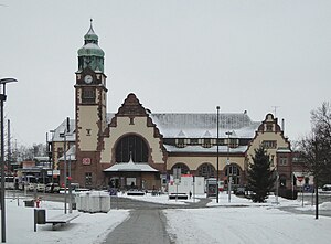
Oberursel station
Railway station in Oberursel, Germany
Distance: Approx. 1346 meters
Latitude and longitude: 50.19888889,8.58833333
Oberursel (Taunus) station is a station on S-Bahn line S5 in Oberursel (Taunus), near Frankfurt am Main, Germany on the Homburg line. The former Mountain Railway (German: Gebirgsbahn) ran from the station to Hohemark; it is now part of U-Bahn line U3.

Kalbach-Riedberg
Borough of Frankfurt am Main in Hesse, Germany
Distance: Approx. 3407 meters
Latitude and longitude: 50.18472222,8.63944444
Kalbach-Riedberg is a borough (Ortsbezirk) of Frankfurt am Main, Germany. It is subdivided into the Stadtbezirke Kalbach and Riedberg. Kalbach has a long history and has been mentioned in documented sources as early as year 772.

European School, Frankfurt am Main
European school in Frankfurt am Main, Hesse, Germany
Distance: Approx. 3922 meters
Latitude and longitude: 50.158024,8.623077
European School, Frankfurt am Main, or ESF (German: Europäische Schule Frankfurt am Main; French: École européenne de Francfort-sur-le-Main) is a European school in Frankfurt, Germany.
Weather in this IP's area
overcast clouds
20 Celsius
20 Celsius
19 Celsius
21 Celsius
1008 hPa
79 %
1008 hPa
989 hPa
10000 meters
2.51 m/s
3.26 m/s
210 degree
92 %
06:51:26
19:55:23