Country:
Region:
City:
Latitude and Longitude:
Time Zone:
Postal Code:
IP information under different IP Channel
ip-api
Country
Region
City
ASN
Time Zone
ISP
Blacklist
Proxy
Latitude
Longitude
Postal
Route
Luminati
Country
Region
eng
City
guildford
ASN
Time Zone
Europe/London
ISP
Datanet.co.uk Ltd
Latitude
Longitude
Postal
IPinfo
Country
Region
City
ASN
Time Zone
ISP
Blacklist
Proxy
Latitude
Longitude
Postal
Route
db-ip
Country
Region
City
ASN
Time Zone
ISP
Blacklist
Proxy
Latitude
Longitude
Postal
Route
ipdata
Country
Region
City
ASN
Time Zone
ISP
Blacklist
Proxy
Latitude
Longitude
Postal
Route
Popular places and events near this IP address

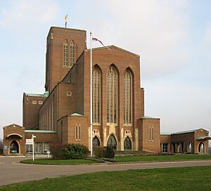
Guildford Cathedral
Church in Surrey, England
Distance: Approx. 1197 meters
Latitude and longitude: 51.2411,-0.59
The Cathedral Church of the Holy Spirit, Guildford, commonly known as Guildford Cathedral, is the Anglican cathedral in Guildford, Surrey, England. Earl Onslow donated the first 6 acres (2.4 ha) of land on which the cathedral stands, with Viscount Bennett, a former Prime Minister of Canada, purchasing the remaining land and donating it to the cathedral in 1947. Designed by Edward Maufe and built between 1936 and 1961, it is the seat of the Bishop of Guildford.

Eagle Radio
Former radio station in Surrey, England
Distance: Approx. 586 meters
Latitude and longitude: 51.2284,-0.6054
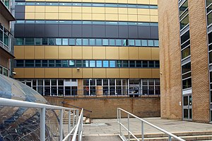
Eagle Radio was an Independent Local Radio station in the Surrey and North East Hampshire area of England. Based in Guildford in the Guildford College campus, Eagle Radio was part of the UKRD Group of radio stations.

Diocese of Guildford
Diocese of the Church of England
Distance: Approx. 1197 meters
Latitude and longitude: 51.2411,-0.59
The Diocese of Guildford is a Church of England diocese covering eight and half of the eleven districts in Surrey, much of north-east Hampshire and a parish in Greater London. The cathedral is Guildford Cathedral and the bishop is the Bishop of Guildford. Of the two provinces of the church, it is in the Province of Canterbury.
Guildford County School
Academy in Guildford, Surrey, United Kingdom
Distance: Approx. 1123 meters
Latitude and longitude: 51.23428,-0.58532
Guildford County School (GCS) is a co-educational day school on Farnham Road (A31), Guildford, England, 200 metres from Guildford town centre. It has around 1050 students enrolled, including the Sixth Form. It is run by its headmaster Steve Smith.

Mount Cemetery
Cemetery in Surrey, England
Distance: Approx. 1321 meters
Latitude and longitude: 51.23071,-0.58271
Mount Cemetery, also known as Guildford Cemetery, is a cemetery in Guildford, Surrey, England. It is the location of Booker's Tower. Guildford Cemetery is surrounded by low-density houses with gardens and a covered reservoir beyond the east corner, immediately south of the successive residential streets of the Guildford Park and Farnham Road neighbourhoods west of Guildford, on the 'Guildown' or 'Mount' section of the western North Downs here forming the widest section of the Hog's Back.
Guildford School of Acting
University of Surrey drama school
Distance: Approx. 1171 meters
Latitude and longitude: 51.2429,-0.5956
Guildford School of Acting (GSA) is a drama school in Guildford, Surrey, England. It is an academic school in the University of Surrey. It is a member of the Federation of Drama Schools.

Royal Surrey County Hospital
English hospital
Distance: Approx. 1010 meters
Latitude and longitude: 51.240542,-0.60936
The Royal Surrey County Hospital (RSCH) is a 520-bed district general hospital, located on the fringe of Guildford, run by the Royal Surrey County Hospital NHS Foundation Trust. Royal Surrey has received excellent recognition by the Care Quality Commission (CQC), with both Royal Surrey County Hospital and their maternity services rated outstanding.

Surrey Research Park
Research park in Guildford, Surrey
Distance: Approx. 1056 meters
Latitude and longitude: 51.239032,-0.612987
The Surrey Research Park is a large research park in Guildford, Surrey. The Surrey Research Park has been planned, developed, funded and managed by the University of Surrey which operates the park as a wholly owned University Enterprise Unit.

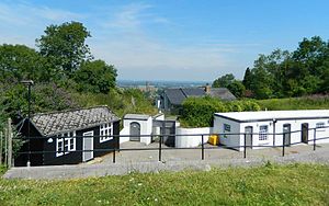
Henley Fort
Distance: Approx. 413 meters
Latitude and longitude: 51.230509,-0.5968996
Henley Fort is a Victorian fort near Guildford, Surrey, at the eastern end of the 'Hog's Back' ridge.
Exterior sculpture of Guildford Cathedral
Distance: Approx. 1197 meters
Latitude and longitude: 51.2411,-0.59
The exterior sculpture of Guildford Cathedral provides many artistic features, including sculptures, engravings and more by some of England’s finest sculptors and craftsmen of the 1950s and 1960s. The people who worked on the cathedral include: Edward Maufe, Alan Collins, Vernon Hill, Eric Gill, John Hutton, Dennis Huntley and others. The cathedral is an Anglican cathedral at Guildford, Surrey, England.

Lewis Elton Gallery
Distance: Approx. 1321 meters
Latitude and longitude: 51.24277778,-0.59055556
The Lewis Elton Gallery was an art gallery at the University of Surrey's Guildford campus, which hosted exhibitions, lectures and events including sculpture, paintings and photographs. The Gallery was also responsible for the maintaining the University Art Collection and a range of special collections including the Lewis and Mary Elton Art Collection and E.H. Shepard archive. The Gallery was named in 1997 after Professor Lewis Elton who initiated the display of original artwork at Surrey University's Physics Department in Battersea in 1963.

Farnham Road Hospital
Hospital in Guildford, England
Distance: Approx. 1191 meters
Latitude and longitude: 51.235278,-0.584607
Farnham Road Hospital is a mental health hospital in Guildford, Surrey. It is managed by Surrey and Borders Partnership NHS Foundation Trust. The main building is a Grade II listed building.
Weather in this IP's area
broken clouds
11 Celsius
10 Celsius
10 Celsius
12 Celsius
1027 hPa
87 %
1027 hPa
1015 hPa
9000 meters
3.6 m/s
80 degree
75 %
06:59:11
16:32:41
