Country:
 Liechtenstein
Region:
City:
Latitude and Longitude:
Time Zone:
Postal Code:
IP information under different IP Channel
ip-api
Country
Region
City
ASN
Time Zone
ISP
Blacklist
Proxy
Latitude
Longitude
Postal
Route
IPinfo
Country
Region
City
ASN
Time Zone
ISP
Blacklist
Proxy
Latitude
Longitude
Postal
Route
MaxMind
Country
Region
City
ASN
Time Zone
ISP
Blacklist
Proxy
Latitude
Longitude
Postal
Route
Luminati
Country
LIRegion
09
City
triesen
ASN
Time Zone
Europe/Vaduz
ISP
Telecom Liechtenstein AG
Latitude
Longitude
Postal
db-ip
Country
Region
City
ASN
Time Zone
ISP
Blacklist
Proxy
Latitude
Longitude
Postal
Route
ipdata
Country
Region
City
ASN
Time Zone
ISP
Blacklist
Proxy
Latitude
Longitude
Postal
Route
Popular places and events near this IP address
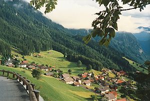
Triesenberg
Municipality in Oberland, Liechtenstein
Distance: Approx. 2011 meters
Latitude and longitude: 47.11805556,9.54333333
Triesenberg (German pronunciation: [ˈtʁiːzn̩ˌbɛʁk] ) is a municipality in Liechtenstein with a population of 2,636. Its area of 29.69 square kilometres (11.46 sq mi) makes it the largest municipality in Liechtenstein. The center of the municipality rests at an elevation of 884–1,000 metres (2,900–3,281 ft).

Triesen
Municipality in Oberland, Liechtenstein
Distance: Approx. 453 meters
Latitude and longitude: 47.1,9.53333333
Triesen (German pronunciation: [ˈtʁiːzn̩] ) is the third largest municipality in Liechtenstein. It contains several historic churches dating from the fifteenth century. It also has a weaving mill from 1863 that is considered a historical monument.
Sücka
Village in Oberland, Liechtenstein
Distance: Approx. 2768 meters
Latitude and longitude: 47.11666667,9.56666667
Sücka is a village of Liechtenstein, located in the municipality of Triesenberg.
Wangerberg
Village in Oberland, Liechtenstein
Distance: Approx. 765 meters
Latitude and longitude: 47.10611111,9.54444444
Wangerberg (also spelled Wangerbärg) is a village of Liechtenstein, located in the municipality of Triesenberg.

Koraspitz
Mountain in Lichtenstein
Distance: Approx. 2728 meters
Latitude and longitude: 47.07916667,9.55777778
Koraspitz is a mountain in Liechtenstein in the Rätikon range of the Eastern Alps with a height of 1,927 metres (6,322 ft).
Langspitz
Mountain in Liechtenstein
Distance: Approx. 2937 meters
Latitude and longitude: 47.07880556,9.56197222
Langspitz is a mountain in Liechtenstein in the Rätikon range of the Eastern Alps with a height of 2,006 metres (6,581 ft).
Goldlochspitz
Mountain in Liechtenstein
Distance: Approx. 2977 meters
Latitude and longitude: 47.08138889,9.56722222
Goldlochspitz is a mountain in Liechtenstein in the Rätikon range of the Eastern Alps with a height of 2,110 metres (6,920 ft).
Kulmi
Mountain in Liechtenstein
Distance: Approx. 2868 meters
Latitude and longitude: 47.0875,9.57222222
Kulmi (or Kolme) is a mountain in Liechtenstein in the Rätikon range of the Eastern Alps with a height of 1,993 metres (6,539 ft).
Heubühl
Mountain in Liechtenstein
Distance: Approx. 2142 meters
Latitude and longitude: 47.09611111,9.56691667
Heubühl is a mountain in Liechtenstein in the Rätikon range of the Eastern Alps, to the east of the town of Triesen, with a height of 1,936 metres (6,352 ft).
Sportanlage Blumenau
Football stadium in Triesen, Liechtenstein
Distance: Approx. 1868 meters
Latitude and longitude: 47.1102,9.5195
Sportanlage Blumenau is a football stadium in Triesen, Liechtenstein. It has a capacity of 2,100 and is the home of FC Triesen.
Sportanlage Leitawies
Football stadium in Triesenberg, Liechtenstein
Distance: Approx. 1593 meters
Latitude and longitude: 47.1145,9.5401
Sportanlange Leitawies is a football stadium in Triesenberg, Liechtenstein. It is the home ground of FC Triesenberg and has a capacity of 800 made up of 400 seats and 400 standing places.
Private University in the Principality of Liechtenstein
Private medical school located in Liechtenstein
Distance: Approx. 1311 meters
Latitude and longitude: 47.1082,9.5266
The Private University in the Principality of Liechtenstein (German: Private Universität im Fürstentum Liechtenstein (UFL)) is one of the four centers for higher education in the Principality of Liechtenstein. It focuses on two main fields of study: Medical Sciences and Law. The university is located in Triesen.
Weather in this IP's area
broken clouds
10 Celsius
8 Celsius
8 Celsius
10 Celsius
1013 hPa
86 %
1013 hPa
939 hPa
10000 meters
3.47 m/s
4.65 m/s
182 degree
79 %
07:27:37
18:51:52