80.65.163.64 - IP Lookup: Free IP Address Lookup, Postal Code Lookup, IP Location Lookup, IP ASN, Public IP
Country:
Region:
City:
Location:
Time Zone:
Postal Code:
IP information under different IP Channel
ip-api
Country
Region
City
ASN
Time Zone
ISP
Blacklist
Proxy
Latitude
Longitude
Postal
Route
Luminati
Country
ASN
Time Zone
Europe/Ljubljana
ISP
SOFTNET d.o.o.
Latitude
Longitude
Postal
IPinfo
Country
Region
City
ASN
Time Zone
ISP
Blacklist
Proxy
Latitude
Longitude
Postal
Route
IP2Location
80.65.163.64Country
Region
federacija bosne i hercegovine
City
kobilja glava
Time Zone
Europe/Sarajevo
ISP
Language
User-Agent
Latitude
Longitude
Postal
db-ip
Country
Region
City
ASN
Time Zone
ISP
Blacklist
Proxy
Latitude
Longitude
Postal
Route
ipdata
Country
Region
City
ASN
Time Zone
ISP
Blacklist
Proxy
Latitude
Longitude
Postal
Route
Popular places and events near this IP address

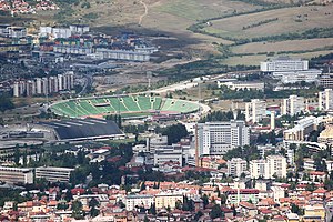
Koševo City Stadium
Stadium at Sarajevo, Bosnia and Herzegovina
Distance: Approx. 1795 meters
Latitude and longitude: 43.87388889,18.40861111
Koševo Stadium (Bosnian:" Stadion Koševo), also Koševo Olympic Stadium or Stadium Asim Ferhatović - Hase (Stadion Asim Ferhatović Hase) is a multi-purpose stadium located in the Koševo neighborhood of Sarajevo, Bosnia and Herzegovina. Its official name is Olimpijski stadion Koševo – Asim Ferhatović-Hase. The stadium was opened by the city, and leased on longterm basis by football club FK Sarajevo.
Horde Zla
Ultras group that supports Bosnia's FK Sarajevo
Distance: Approx. 1795 meters
Latitude and longitude: 43.87388889,18.40861111
Horde Zla (English: Hordes of Evil) is the organized Ultras group that supports Bosnian football club FK Sarajevo. The group's logo consists of a stylized depiction of the Grim Reaper, borrowed from a Zagor comic book at the time of the group's inception. Horde zla is one of two major football fan groups in Bosnia and Herzegovina.

Centar, Sarajevo
Municipality in Federation of Bosnia and Herzegovina, Bosnia and Herzegovina
Distance: Approx. 2127 meters
Latitude and longitude: 43.86888889,18.40861111
Centar (Cyrillic: Центар, lit. ”Center") is a municipality of the city of Sarajevo, Bosnia and Herzegovina. It is located between the older parts of the city under Stari Grad, and the newer more modern parts of the city under the municipalities Novi Grad and Novo Sarajevo.

Zetra Olympic Hall, Sarajevo
Indoor arena in Sarajevo, Bosnia and Herzegovina
Distance: Approx. 1983 meters
Latitude and longitude: 43.87180556,18.40955556
The Juan Antonio Samaranch Olympic Hall (Bosnian, Croatian and Serbian: Olimpijska dvorana Juan Antonio Samaranch / Олимпијска дворана Хуан Антонио Самаран; formerly Zetra Olympic Hall) is an indoor multi-purpose arena in Sarajevo, Bosnia and Herzegovina. Named in honor of Juan Antonio Samaranch in 2010 after his death, it was used for various sporting events at the 1984 Winter Olympics, and as the main venue of the 2019 European Youth Olympic Winter Festival.
Hotonj
Place in Federation of Bosnia and Herzegovina, Bosnia and Herzegovina
Distance: Approx. 1785 meters
Latitude and longitude: 43.89,18.37
Hotonj is a settlement Vogošća municipality, near Sarajevo, Federation of Bosnia and Herzegovina, Bosnia and Herzegovina.
Grahovište
Village in Federation of Bosnia and Herzegovina, Bosnia and Herzegovina
Distance: Approx. 984 meters
Latitude and longitude: 43.88,18.37722222
Grahovište is a village in Vogošća municipality, near Sarajevo, Federation of Bosnia and Herzegovina, Bosnia and Herzegovina.
Zetra Ice Rink
Sports venue in Sarajevo
Distance: Approx. 2049 meters
Latitude and longitude: 43.870403,18.409138
The Zetra Ice Rink or Zetra Stadium (Bosnian: Olimpijska Dvorana Zetra) is an outdoor venue located in Sarajevo, Bosnia and Herzegovina. Constructed between 1981 and 1982, it hosted the speed skating events for the 1984 Winter Olympics. This venue is located near the Olympic Hall Juan Antonio Samaranch, formerly known as the Zetra Ice Rink.

FK Sarajevo Youth School
Football club
Distance: Approx. 1795 meters
Latitude and longitude: 43.87388889,18.40861111
The FK Sarajevo Youth School (Bosnian: Omladinski pogon Fudbalskog kluba Sarajevo), is the youth department for Bosnian football club FK Sarajevo and is considered to be the best in the country. The department is split into two sections. Namely, The Asim Ferhatović Hase School of Football (Bosnian: Škola fudbala Asim Ferhatović Hase), named after legendary striker Asim Ferhatović, and the FK Sarajevo Academy (Bosnian: Akademija fudbalskog kluba Sarajevo).

Hum Tower
Telecommunication and observation in Sarajevo, Bosnia and Herzegovina
Distance: Approx. 1072 meters
Latitude and longitude: 43.87247222,18.38647222
The Hum Tower (Bosnian: Toranj Hum / Predajnik Hum) is a 78.5 m (258 ft) tall telecommunication tower located on Mount Hum in the periphery of Sarajevo. The original tower was finished in the 1960s, rebuilt in the 1980s.

Koševo
Neighborhood in Bosnia and Herzegovina
Distance: Approx. 2115 meters
Latitude and longitude: 43.87244444,18.41205556
Koševo (Cyrillic: Кошево) is a neighborhood in the municipality of Centar in central Sarajevo in Bosnia and Herzegovina. It is located between the older parts of the city under Stari Grad and the newer more modern parts of the city under the municipality of Novo Sarajevo. The Koševo City Stadium and Zetra Olympic Hall, at which the opening and closing ceremonies of the 1984 Winter Olympics were held, are part of a huge sport complex, which includes the Faculty of Sport and Physical Culture and the university's swimming pool as well, located in Koševo.
Dubravko Lovrenović
Bosnian and Yugoslav historian (1956–2017)
Distance: Approx. 927 meters
Latitude and longitude: 43.8765,18.398
Dubravko Lovrenović (30 August 1956 – 17 January 2017) was a Bosnian and Herzegovinian medievalist, author and essayist, who worked at the Faculty of Philosophy of the University of Sarajevo, Department of History, in Sarajevo, Bosnia and Herzegovina.
Mount Hum (Sarajevo)
Hill in Sarajevo, Bosnia and Herzegovina
Distance: Approx. 1404 meters
Latitude and longitude: 43.8725279,18.3774932
Hum, also referred to as Hum Brdo (lit. "Hum Hill"), is a small mountain located north of Sarajevo, Bosnia and Herzegovina. At its top is the Hum Tower.
Weather in this IP's area
mist
-4 Celsius
-4 Celsius
-4 Celsius
-4 Celsius
1032 hPa
93 %
1032 hPa
957 hPa
1500 meters
0.51 m/s
100 %
