Country:
 Switzerland
Region:
City:
Latitude and Longitude:
Time Zone:
Postal Code:
IP information under different IP Channel
ip-api
Country
Region
City
ASN
Time Zone
ISP
Blacklist
Proxy
Latitude
Longitude
Postal
Route
IPinfo
Country
Region
City
ASN
Time Zone
ISP
Blacklist
Proxy
Latitude
Longitude
Postal
Route
MaxMind
Country
Region
City
ASN
Time Zone
ISP
Blacklist
Proxy
Latitude
Longitude
Postal
Route
Luminati
Country
CHRegion
lu
City
lucerne
ASN
Time Zone
Europe/Zurich
ISP
green.ch AG
Latitude
Longitude
Postal
db-ip
Country
Region
City
ASN
Time Zone
ISP
Blacklist
Proxy
Latitude
Longitude
Postal
Route
ipdata
Country
Region
City
ASN
Time Zone
ISP
Blacklist
Proxy
Latitude
Longitude
Postal
Route
Popular places and events near this IP address
Dielsdorf District
District in Switzerland
Distance: Approx. 830 meters
Latitude and longitude: 47.48333333,8.45
Dielsdorf District is a district in the northwestern part of the Swiss canton of Zürich. Since 1871 the administrative center of the district is located in Dielsdorf. Previously the district was named Bezirk Regensberg, and its capital was Regensdorf, the only city in the district.

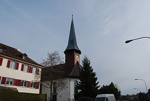
Dielsdorf
Municipality in Zurich, Switzerland
Distance: Approx. 830 meters
Latitude and longitude: 47.48333333,8.45
Dielsdorf is a municipality, seat of the district of Dielsdorf in the canton of Zürich in Switzerland.
Niederhasli
Municipality in Zurich, Switzerland
Distance: Approx. 3336 meters
Latitude and longitude: 47.48333333,8.48333333
Niederhasli is a municipality in the district of Dielsdorf in the canton of Zürich in Switzerland.

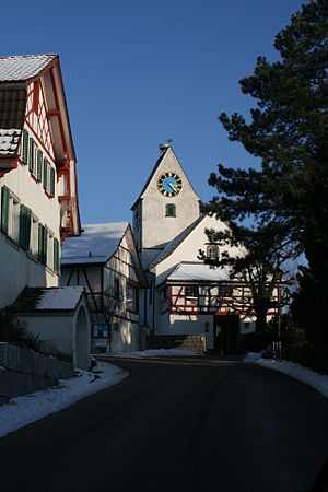
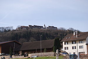
Regensberg
Municipality in Zurich, Switzerland
Distance: Approx. 431 meters
Latitude and longitude: 47.48333333,8.43333333
Regensberg is a municipality in the Dielsdorf District in the Swiss canton of Zurich. It is located just to the west of Dielsdorf municipality, on a ridge of the Lägern (617 m (2,024 ft)).
Buchs, Zürich
Municipality in Zürich, Switzerland
Distance: Approx. 1965 meters
Latitude and longitude: 47.46666667,8.43333333
Buchs (German pronunciation: [bʊks] ) is a municipality in the district of Dielsdorf in the canton of Zürich in Switzerland.

Schöfflisdorf
Municipality in Zürich, Switzerland
Distance: Approx. 1681 meters
Latitude and longitude: 47.48333333,8.41666667
Schöfflisdorf is a municipality in the district of Dielsdorf in the canton of Zürich in Switzerland.
Steinmaur
Municipality in Zurich, Switzerland
Distance: Approx. 1974 meters
Latitude and longitude: 47.5,8.45
Steinmaur is a municipality in the district of Dielsdorf in the canton of Zürich in Switzerland.

Crossair Flight 498
January 2000 plane crash in Zürich, Switzerland
Distance: Approx. 2799 meters
Latitude and longitude: 47.47,8.47
Crossair Flight 498 was a scheduled commuter flight from Zürich, Switzerland, to Dresden, Germany. On 10 January 2000, the Saab 340B operating the flight crashed two minutes after takeoff in the Swiss municipality of Niederhasli on 10 January 2000, killing all 10 passengers and crew. It was one of two fatal crashes for Crossair during its existence; the other was Crossair Flight 3597 which crashed less than 2 years later during approach to Zurich.
Furttal
Distance: Approx. 3020 meters
Latitude and longitude: 47.46,8.42
Furttal is a valley region in Switzerland between Lägern and Altberg in the Dielsdorf district of the canton of Zurich. The area's name stems from the German word for ford, or furt, and is named after the crossing over the Limmat in the community of Würenlos on the west side of the region. The area is bordered in the east near the community of Regensdorf by the Katzensee lakes.

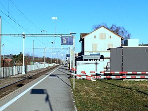
Dielsdorf railway station
Railway station in Switzerland
Distance: Approx. 1544 meters
Latitude and longitude: 47.48241,8.45940694
Dielsdorf railway station is a railway station in the Swiss canton of Zurich and municipality of Dielsdorf. The station is located on the Wehntal railway line, and is served by Zurich S-Bahn line S15. The station was opened in 1865, and was initially the terminus of a branch of the Bülach-Regensberg Railway from Oberglatt.
Schöfflisdorf-Oberweningen railway station
Railway station in Switzerland
Distance: Approx. 2578 meters
Latitude and longitude: 47.49797,8.41177694
Schöfflisdorf-Oberweningen railway station is a railway station in the municipalities of Schöfflisdorf in the Swiss canton of Zurich. The station takes its name from the adjoining municipalities of Schöfflisdorf and Oberweningen. It is located on the Wehntal railway line, and is served by Zurich S-Bahn line S15.
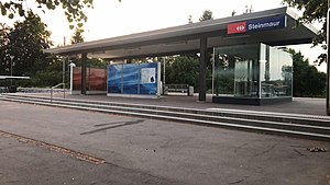
Steinmaur railway station
Railway station
Distance: Approx. 897 meters
Latitude and longitude: 47.48998,8.44682694
Steinmaur railway station (German: Bahnhof Steinmaur) is a railway station in the municipality of Steinmaur, in the Swiss canton of Zürich. It is an intermediate stop on the standard gauge Wehntal line of Swiss Federal Railways.
Weather in this IP's area
mist
10 Celsius
10 Celsius
9 Celsius
11 Celsius
1019 hPa
96 %
1019 hPa
951 hPa
3000 meters
0.51 m/s
75 %
07:50:50
18:31:09