Country:
Region:
City:
Latitude and Longitude:
Time Zone:
Postal Code:
IP information under different IP Channel
ip-api
Country
Region
City
ASN
Time Zone
ISP
Blacklist
Proxy
Latitude
Longitude
Postal
Route
Luminati
Country
Region
so
City
kaposvar
ASN
Time Zone
Europe/Budapest
ISP
Invitech ICT Services Kft.
Latitude
Longitude
Postal
IPinfo
Country
Region
City
ASN
Time Zone
ISP
Blacklist
Proxy
Latitude
Longitude
Postal
Route
db-ip
Country
Region
City
ASN
Time Zone
ISP
Blacklist
Proxy
Latitude
Longitude
Postal
Route
ipdata
Country
Region
City
ASN
Time Zone
ISP
Blacklist
Proxy
Latitude
Longitude
Postal
Route
Popular places and events near this IP address

Kaposvár
City with county rights in Southern Transdanubia, Hungary
Distance: Approx. 1059 meters
Latitude and longitude: 46.36383,17.78225
Kaposvár (Hungarian pronunciation: [ˈkɒpoʃvaːr]; also known by alternative names) is a city with county rights in southwestern Hungary, south of Lake Balaton. It is one of the leading cities of Transdanubia, the capital of Somogy County, and the seat of the Kaposvár District and the Roman Catholic Diocese of Kaposvár.
Rákóczi Stadion
Distance: Approx. 1569 meters
Latitude and longitude: 46.356573,17.806038
Rákóczi Stadion is a multi-use stadium in Kaposvár, Hungary. It is currently used mostly for football matches and is the home stadium of Kaposvári Rákóczi FC. The stadium is able to hold 7,000 people. It has 4,500 seats.
Kaposszerdahely
Village in Southern Transdanubia, Hungary
Distance: Approx. 5834 meters
Latitude and longitude: 46.32254,17.75723
Kaposszerdahely is a village in Somogy county, Hungary.

Kaposújlak
Village in Southern Transdanubia, Hungary
Distance: Approx. 4976 meters
Latitude and longitude: 46.36719,17.72973
Kaposújlak is a village in Somogy county, Hungary.

Roman Catholic Diocese of Kaposvár
Latin Catholic jurisdiction in Hungary
Distance: Approx. 1272 meters
Latitude and longitude: 46.3577125,17.7879404
The Diocese of Kaposvár (Latin: Dioecesis Kaposvarensis) is a Latin suffragan diocese in the ecclesiastical province of the Metropolitan Archdiocese of Veszprém, in southwestern Hungary. Its cathedral episcopal, Our Lady of the Assumption Cathedral, is dedicated to the Blessed Virgin Mary (Hungarian: Nagyboldogasszony-székesegyház), in the city of Kaposvár, capital of Somogy County.
University of Kaposvár
Distance: Approx. 3065 meters
Latitude and longitude: 46.385,17.82611111
The University of Kaposvár is a university in Hungary. It was established in 2000. It offers undergraduate and postgraduate education.

Kaposszentjakab
Distance: Approx. 3107 meters
Latitude and longitude: 46.35555556,17.83055556
Kaposszentjakab (formerly called Zselicszentjakab) is the site of a ruined Benedictine monastery. The monastery site and the surrounding village is now a suburb of the city of Kaposvár in southwestern Hungary.

Lake Deseda
Distance: Approx. 4526 meters
Latitude and longitude: 46.4064,17.8147
Deseda is a lake located in Hungary.

Zselicszentjakab Abbey
Benedictine monastery in Hungary
Distance: Approx. 4061 meters
Latitude and longitude: 46.35805556,17.84527778
The Zselicszentjakab Abbey was a Benedictine monastery established at Zselicszentjakab (now Kaposszentjakab) in Somogy County in the Kingdom of Hungary in 1061. Its founder was the Palatine Otto of the Győr clan. The monastery was dedicated to the Apostle Saint James the Great.
Kaposfüred
Quarter in Somogy, Hungary
Distance: Approx. 1059 meters
Latitude and longitude: 46.36383,17.78225
Kaposfüred (officially Kaposvár-Kaposfüred) is located on the north side of Kaposvár. Before 1970, it was an independent village.
Our Lady of the Assumption Cathedral, Kaposvár
Church in Kaposvár, Hungary
Distance: Approx. 1414 meters
Latitude and longitude: 46.3564,17.7877
The Our Lady of the Assumption Cathedral (Hungarian: Nagyboldogasszony székesegyház) also called Kaposvár Cathedral It is located in the historic center of Kaposvár, is a religious building affiliated with the Catholic Church which is one of the largest Christian churches in Hungary, serves as the seat of the diocese of Kaposvár. Its construction began in 1885 and was completed in 1886. The first church was built in 1737–1744 in the Baroque style.

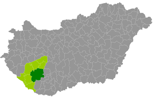
Kaposvár District
Districts of Hungary in Southern Transdanubia
Distance: Approx. 1478 meters
Latitude and longitude: 46.3549358,17.79378027
Kaposvár (Hungarian: Kaposvári járás) is a district in the central-eastern part of Somogy County in Hungary. Kaposvár is also the name of the town where the district and county seat are located. The district is in the Southern Transdanubia Statistical Region.
Weather in this IP's area
clear sky
4 Celsius
3 Celsius
4 Celsius
4 Celsius
1014 hPa
74 %
1014 hPa
996 hPa
10000 meters
1.51 m/s
1.49 m/s
99 degree
06:53:36
16:14:22

