Country:
 Belgium
Region:
City:
Latitude and Longitude:
Time Zone:
Postal Code:
IP information under different IP Channel
ip-api
Country
Region
City
ASN
Time Zone
ISP
Blacklist
Proxy
Latitude
Longitude
Postal
Route
IPinfo
Country
Region
City
ASN
Time Zone
ISP
Blacklist
Proxy
Latitude
Longitude
Postal
Route
MaxMind
Country
Region
City
ASN
Time Zone
ISP
Blacklist
Proxy
Latitude
Longitude
Postal
Route
Luminati
Country
BERegion
wal
City
binche
ASN
Time Zone
Europe/Brussels
ISP
Sewan Belgium SA
Latitude
Longitude
Postal
db-ip
Country
Region
City
ASN
Time Zone
ISP
Blacklist
Proxy
Latitude
Longitude
Postal
Route
ipdata
Country
Region
City
ASN
Time Zone
ISP
Blacklist
Proxy
Latitude
Longitude
Postal
Route
Popular places and events near this IP address
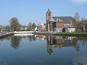
La Louvière
City and municipality in Hainaut Province, Belgium
Distance: Approx. 5752 meters
Latitude and longitude: 50.46666667,4.18333333
La Louvière (French pronunciation: [la luvjɛʁ] ; Walloon: El Lovire) is a city and municipality of Wallonia located in the province of Hainaut, Belgium. The municipality consists of the following districts: Boussoit, Haine-Saint-Paul, Haine-Saint-Pierre, Houdeng-Aimeries, Houdeng-Gœgnies, La Louvière, Maurage, Saint-Vaast, Strépy-Bracquegnies, and Trivières. La Louvière is the capital of the Centre region, a former coal mining area in the Sillon industriel, between the Borinage to the West and the Pays Noir to the East.
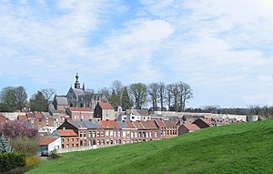
Binche
City and municipality in French Community, Belgium
Distance: Approx. 1764 meters
Latitude and longitude: 50.4,4.16666667
Binche (French pronunciation: [bɛ̃ʃ] ; Walloon: Bince; Dutch: Bing) is a city and municipality of Wallonia, in the province of Hainaut, Belgium. Since 1977, the municipality consists of Binche, Bray, Buvrinnes, Épinois, Leval-Trahegnies, Péronnes-lez-Binche, Ressaix, and Waudrez districts. According to the surveys from 2021, Binche had a total population of 33,416, approximately 550 inhabitants per km2.

Estinnes
Municipality in French Community, Belgium
Distance: Approx. 5328 meters
Latitude and longitude: 50.4,4.1
Estinnes (French pronunciation: [ɛstin] ; Picard: L' Estene) is a municipality of Wallonia located in the province of Hainaut, Belgium. On 1 January 2006, Estinnes had a total population of 7,413. The total area is 72.73 km2 which gives a population density of 102 inhabitants per km2.

Morlanwelz
Municipality in French Community, Belgium
Distance: Approx. 5848 meters
Latitude and longitude: 50.45,4.23333333
Morlanwelz (French pronunciation: [mɔʁlɑ̃we] ; Walloon: Marlanwé) is a municipality of Wallonia located in the province of Hainaut, Belgium. On 1 January 2006 Morlanwelz had a total population of 18,595. The total area is 20.26 km2 which gives a population density of 918 inhabitants per km2.
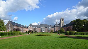
Bonne-Espérance Abbey
Premonstratensian abbey in France
Distance: Approx. 3963 meters
Latitude and longitude: 50.38611,4.13972
Bonne-Espérance Abbey (French: Abbaye de Bonne-Espérance) was a Premonstratensian abbey that existed from 1130 to the end of the 18th century, located in Vellereille-les-Brayeux in the Walloon municipality of Estinnes, province of Hainaut, Diocese of Tournai, in present-day Belgium.

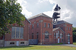
Triage-Lavoir de Péronnes
Industrial in Binche, Belgium
Distance: Approx. 1326 meters
Latitude and longitude: 50.4275,4.17166667
Triage-Lavoir de Péronnes is a former coal washing facility that was built with the help of the Marshall Plan in 1954. It was built for the demand of the coal industry to process the coal coming from the mines of Péronnes, Ressaix and Trivières. It was capable processing over 3,000 tons of coal daily.
Mont-Sainte-Aldegonde
Distance: Approx. 4841 meters
Latitude and longitude: 50.43333333,4.23333333
Mont-Sainte-Aldegonde (Walloon: Li Mont) is a village of Wallonia and a district of the municipality of Morlanwelz, located in the province of Hainaut, Belgium.
Bois-du-Luc
Ancient coal mine in Belgium
Distance: Approx. 6288 meters
Latitude and longitude: 50.470461,4.149881
The Bois-du-Luc was a coal mine in Houdeng-Aimeries, near La Louvière, in Belgium which today is preserved as an industrial heritage site. As well as the site of the headquarters of the Société des Charbonnages de Bois-du-Luc et d'Havre, the Bois du Luc was the site of the Saint Emmanuel Pit (Fosse Saint-Emmanuel) which belonged to the company. The Fosse Saint-Emmanuel was one of the oldest mines in Belgium, with recorded activity dating back to 1685.

Trivières
Distance: Approx. 4282 meters
Latitude and longitude: 50.45111111,4.14777778
Trivières (Walloon: Triviere) is a village of Wallonia and a district of the municipality of La Louvière, located in the province of Hainaut, Belgium. It is located between Mons and Charleroi, about 35 miles (56 km) south of Brussels. It was a fully fledged municipality before the fusion of the Belgian municipalities.

Binche Palace
Former royal residence in Binche, Belgium
Distance: Approx. 942 meters
Latitude and longitude: 50.40805556,4.165
Binche Palace (French: Palais de Binche) was a royal residence located in Binche, in today's Belgian province of Hainaut, Wallonia. The medieval castle and subsequent Renaissance palace served as residence for the counts of Hainaut, the dukes of Burgundy and the Habsburg rulers of the Netherlands. The palace was built between 1546 and 1549 by order of Queen Mary of Hungary, governor of the Netherlands, and was one of the first Renaissance palaces in the Low Countries, intended to rival the French Palace of Fontainebleau.
Fayt-lez-Manage
Place in Wallonia, Belgium
Distance: Approx. 3469 meters
Latitude and longitude: 50.4278,4.216
Fayt-lez-Manage (French: [fa(j)ilemanaʒ], literally Fayt near Manage; Walloon: El Fayi-dlé-Manadje) is a town of Wallonia and a district of the municipality of Manage, located in the province of Hainaut, Belgium. The name dates to 1920, previously it was called Fayt-lez-Seneffe. It was a municipality in its own right before the merger of the municipalities in 1977.

Arrondissement of La Louvière
Arrondissement in Wallonia, Belgium
Distance: Approx. 3889 meters
Latitude and longitude: 50.38333333,4.15
The Arrondissement of La Louvière (French: Arrondissement de La Louvière) is one of the seven administrative arrondissements in the Walloon province of Hainaut, Belgium. The Arrondissement of La Louvière was created in 2019 from the municipalities of La Louvière (formerly from Arrondissement of Soignies) and Binche, Estinnes, and Morlanwelz (formerly from Arrondissement of Thuin).
Weather in this IP's area
scattered clouds
13 Celsius
12 Celsius
12 Celsius
13 Celsius
1009 hPa
79 %
1009 hPa
998 hPa
10000 meters
8.97 m/s
15.79 m/s
232 degree
43 %
07:43:48
19:21:48