Country:
 Czech Republic
Region:
City:
Latitude and Longitude:
Time Zone:
Postal Code:
IP information under different IP Channel
ip-api
Country
Region
City
ASN
Time Zone
ISP
Blacklist
Proxy
Latitude
Longitude
Postal
Route
IPinfo
Country
Region
City
ASN
Time Zone
ISP
Blacklist
Proxy
Latitude
Longitude
Postal
Route
MaxMind
Country
Region
City
ASN
Time Zone
ISP
Blacklist
Proxy
Latitude
Longitude
Postal
Route
Luminati
Country
CZRegion
10
City
prague
ASN
Time Zone
Europe/Prague
ISP
WIA spol. s.r.o.
Latitude
Longitude
Postal
db-ip
Country
Region
City
ASN
Time Zone
ISP
Blacklist
Proxy
Latitude
Longitude
Postal
Route
ipdata
Country
Region
City
ASN
Time Zone
ISP
Blacklist
Proxy
Latitude
Longitude
Postal
Route
Popular places and events near this IP address

Prague Zoo
Zoo in Prague, Czech Republic
Distance: Approx. 994 meters
Latitude and longitude: 50.11694444,14.40611111
Prague Zoological Garden (Czech: Zoologická zahrada hl. m. Prahy) is a zoo in Prague, Czech Republic.

Stadion Juliska
Distance: Approx. 1557 meters
Latitude and longitude: 50.11194444,14.3875
Stadion Juliska is a multi-use stadium in Prague-Dejvice, Czech Republic. It is currently used mostly for football matches and is the home ground of FK Dukla Prague. The stadium is also used for athletics events, including the annual Josef Odložil Memorial.

Sewage Plant in Bubeneč (Prague)
Building in Prague , Czech Republic
Distance: Approx. 1493 meters
Latitude and longitude: 50.11095278,14.40124167
Sewage Plant in Bubeneč (Czech: Čistírna odpadních vod v Bubenči) is the oldest sewage treatment plant in Prague designed by William Heerlein Lindley and built between 1895–1906. In 1991, the building was declared a protected national monument and has been converted into the Eco-technical Museum.

Troja Palace
Distance: Approx. 1369 meters
Latitude and longitude: 50.11643,14.41287
Troja Palace (Czech: Zámek Troja) is a Baroque palace located in Troja, Prague's north-west borough (Czech Republic). It was built for the Counts of Sternberg from 1679 to 1691. The palace is owned by the city of Prague and hosts the 19th century Czech art collections of the City Gallery.
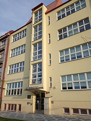
Riverside School, Prague
Independent, non-profit school in Czech Republic
Distance: Approx. 605 meters
Latitude and longitude: 50.12961389,14.39866111
Riverside International School (Riverside) is an international school in Prague being both independent and non-profit. It is a day school offering students aged 3–18 an international approach to education in the English language that opened in 1994. The curriculum is based on the British National Curriculum and the Senior High offers IGCSE's and the International Baccalaureate (IB) Diploma Programme.

Institute of Chemical Process Fundamentals
Distance: Approx. 1115 meters
Latitude and longitude: 50.127,14.383
Institute of Chemical Process Fundamentals, Academy of Sciences of the Czech Republic, v.v.i. (Czech: Ústav chemických procesů Akademie věd České republiky) is one of the six institutes belonging to the CAS chemical sciences section and is a research centre in a variety of fields such as chemistry, biochemistry, catalysis and environment. Its research topics include multiphase reaction systems for the design of chemical synthesis chemical processes and new materials development, energetics and protection of environment.

Bohnice
District of Prague, Czechia
Distance: Approx. 1221 meters
Latitude and longitude: 50.1315,14.41077778
Bohnice (Czech pronunciation: [ˈboɦɲɪtsɛ]) is a district in Prague 8, Czechia, some 5 km north of the city centre. It is home to a psychiatric hospital and a large panel housing estate in which all the streets are named after cities or regions of Poland.
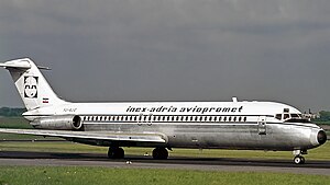
Inex-Adria Aviopromet Flight 450
1975 aviation accident
Distance: Approx. 1587 meters
Latitude and longitude: 50.1375,14.39
Inex-Adria Aviopromet Flight 450, JP 450, was an international charter flight from Tivat in the Socialist Federal Republic of Yugoslavia to Prague, Czechoslovakia which crashed in the Prague suburb of Suchdol on October 30, 1975, at 09:20 AM. The McDonnell Douglas DC-9-32 with 115 passengers and 5 crew on board descended, under Instrument Meteorological Conditions (IMC), below defined Minimum Descent Altitude (MDA) during the final approach to Prague Ruzyně Airport RWY 25, entered a gorge above Vltava river, and was unable to outclimb the rising terrain. 75 of the 120 occupants died during the crash itself while 4 others died later in hospital. The accident remains the worst aviation disaster on the Czech Republic soil.

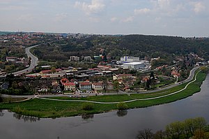
Troja (Prague)
Cadastral area in Prague, Czechia
Distance: Approx. 1217 meters
Latitude and longitude: 50.119,14.413
Troja became part of Prague in 1922. Now it is part of the district of Prague 7 and its own cadastral area. The area is 5.43 km2, the population is 1,468 and the population density is 270 inhabitants / km2.

Praha-Podbaba railway station
Distance: Approx. 1326 meters
Latitude and longitude: 50.1124,14.3955
Praha–Podbaba is a railway halt (Czech: zastávka) located in Bubeneč in Prague 6. It lies on the railway line from Prague to Děčín, and was opened in 2014 to replace the closed Praha-Bubeneč railway station a short distance south down the line. It is served by fast trains from Prague to Děčín as well as local services integrated into the Esko Prague system.
Sedlec (Prague)
Cadastral district of Prague in Czech Republic
Distance: Approx. 946 meters
Latitude and longitude: 50.13111111,14.39027778
Sedlec is a cadastral district of Prague, Czech Republic. In 2015 it had 892 inhabitants. The German name of Sedlec is Selz.

Baba (ruins)
Castle ruins in Prague, Czech Republic
Distance: Approx. 797 meters
Latitude and longitude: 50.1188333,14.3906111
Baba (Czech: Zřícenina Baba) are remains of a 17th-century winepress and an imitation of a castle ruin in Prague in the Czech Republic. It is located on a promontory on the left bank of the Vltava in Dejvice, on Baba hill (259 m above sea level). The spot offers views of Troja, Bubeneč, and Dejvice, and it is a dominant feature of this part of the valley.
Weather in this IP's area
moderate rain
9 Celsius
7 Celsius
8 Celsius
10 Celsius
1017 hPa
96 %
1017 hPa
994 hPa
8000 meters
4.12 m/s
350 degree
100 %
07:08:52
18:32:22