80.244.157.158 - IP Lookup: Free IP Address Lookup, Postal Code Lookup, IP Location Lookup, IP ASN, Public IP
Country:
Region:
City:
Location:
Time Zone:
Postal Code:
IP information under different IP Channel
ip-api
Country
Region
City
ASN
Time Zone
ISP
Blacklist
Proxy
Latitude
Longitude
Postal
Route
Luminati
Country
Region
18
City
blazowa
ASN
Time Zone
Europe/Warsaw
ISP
Multimedia Polska Sp. z o.o.
Latitude
Longitude
Postal
IPinfo
Country
Region
City
ASN
Time Zone
ISP
Blacklist
Proxy
Latitude
Longitude
Postal
Route
IP2Location
80.244.157.158Country
Region
podkarpackie
City
polanczyk
Time Zone
Europe/Warsaw
ISP
Language
User-Agent
Latitude
Longitude
Postal
db-ip
Country
Region
City
ASN
Time Zone
ISP
Blacklist
Proxy
Latitude
Longitude
Postal
Route
ipdata
Country
Region
City
ASN
Time Zone
ISP
Blacklist
Proxy
Latitude
Longitude
Postal
Route
Popular places and events near this IP address

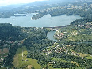
Lake Solina
Lake in Poland
Distance: Approx. 2310 meters
Latitude and longitude: 49.37416667,22.45222222
Lake Solina (Polish: Jezioro Solińskie) is an artificial lake in the Bieszczady Mountains region, in Lesko County of the Subcarpathian Voivodship, Poland. Created in 1968, it is Poland's largest artificial lake as well as a major tourist attraction of the region. The Solina Dam constructed in order to create the lake is also Poland's tallest dam and is used to produce hydroelectric power.

Solina Dam
Dam in Solina
Distance: Approx. 3703 meters
Latitude and longitude: 49.39556389,22.45323611
The Solina Dam (Polish: Zapora Solińska) is a concrete gravity dam in south-eastern Poland. It is the largest dam in the country. It is located in Solina of Lesko County in the Bieszczady Mountains area of Poland.

Polańczyk
Village in Subcarpathian Voivodeship, Poland
Distance: Approx. 104 meters
Latitude and longitude: 49.36944444,22.41972222
Polańczyk [pɔˈlaɲt͡ʂɨk] is a village in Lesko County, Subcarpathian Voivodeship, in south-eastern Poland. It lies in, and serves as the seat of, the administrative district of Gmina Solina. Polańczyk lies approximately 4 kilometres (2 mi) south-west of Solina, 14 km (9 mi) south-east of Lesko, and 80 km (50 mi) south of the regional capital Rzeszów.
Berezka
Village in Subcarpathian Voivodeship, Poland
Distance: Approx. 3540 meters
Latitude and longitude: 49.39277778,22.3875
Berezka [bɛˈrɛska] is a village in the administrative district of Gmina Solina, within Lesko County, Subcarpathian Voivodeship, in south-eastern Poland. It lies approximately 23 kilometres (14 mi) north of Solina, 14 km (9 mi) north-east of Lesko, and 58 km (36 mi) south-east of the regional capital Rzeszów.
Gmina Solina
Gmina in Subcarpathian Voivodeship, Poland
Distance: Approx. 3635 meters
Latitude and longitude: 49.38333333,22.46666667
Gmina Solina is a rural gmina (administrative district) in Lesko County, Subcarpathian Voivodeship, in south-eastern Poland. It takes its name from its former seat, the village of Solina, which lies approximately 15 kilometres (9 mi) south-east of Lesko and 80 km (50 mi) south-east of the regional capital Rzeszów. The present seat is Polańczyk.
Solina, Poland
Village in Subcarpathian Voivodeship, Poland
Distance: Approx. 3635 meters
Latitude and longitude: 49.38333333,22.46666667
Solina [sɔˈlʲina] is a village in Lesko County, Subcarpathian Voivodeship, in south-eastern Poland. It is the former seat of the gmina (administrative district) called Gmina Solina (in 1999 Polańczyk became the new seat). It lies approximately 15 kilometres (9 mi) south-east of Lesko and 80 km (50 mi) south-east of the regional capital Rzeszów.

Jawor, Gmina Solina
Village in Subcarpathian Voivodeship, Poland
Distance: Approx. 3024 meters
Latitude and longitude: 49.38694444,22.45333333
Jawor [ˈjavɔr] is a village in the administrative district of Gmina Solina, within Lesko County, Subcarpathian Voivodeship, in south-eastern Poland. It lies approximately 2 kilometres (1 mi) north-west of Solina, 14 km (9 mi) south-east of Lesko, and 79 km (49 mi) south-east of the regional capital Rzeszów.
Myczków
Village in Subcarpathian Voivodeship, Poland
Distance: Approx. 1304 meters
Latitude and longitude: 49.37944444,22.41111111
Myczków [ˈmɨt͡ʂkuf] is a village in the administrative district of Gmina Solina, within Lesko County, Subcarpathian Voivodeship, in south-eastern Poland. It lies approximately 5 kilometres (3 mi) west of Solina, 13 km (8 mi) south-east of Lesko, and 79 km (49 mi) south of the regional capital Rzeszów.
Rybne, Podkarpackie Voivodeship
Village in Subcarpathian Voivodeship, Poland
Distance: Approx. 3368 meters
Latitude and longitude: 49.34222222,22.40166667
Rybne ([ˈrɨbnɛ]) is a village in the administrative district of Gmina Solina, within Lesko County, Subcarpathian Voivodeship, in south-eastern Poland. It lies approximately 7 km southwest of Solina, 16 km (10 mi) south of Lesko, and 82 km (51 mi) south of the regional capital Rzeszów.
Werlas
Village in Subcarpathian Voivodeship, Poland
Distance: Approx. 3979 meters
Latitude and longitude: 49.34583333,22.46194444
Werlas [ˈvɛrlas] is a village in the administrative district of Gmina Solina, within Lesko County, Subcarpathian Voivodeship, in south-eastern Poland. It lies approximately 5 kilometres (3 mi) to the south of Solina, 18 km (11 mi) south-east of Lesko, and 84 km (52 mi) south-east of the regional capital Rzeszów.
Wola Matiaszowa
Village in Subcarpathian Voivodeship, Poland
Distance: Approx. 3130 meters
Latitude and longitude: 49.38333333,22.38333333
Wola Matiaszowa [ˈvɔla matjaˈʂɔva] is a village in the administrative district of Gmina Solina, within Lesko County, Subcarpathian Voivodeship, in south-eastern Poland. It lies approximately 7 kilometres (4 mi) west of Solina, 11 km (7 mi) south of Lesko, and 78 km (48 mi) south of the regional capital Rzeszów.
Zawóz
Village in Subcarpathian Voivodeship, Poland
Distance: Approx. 3033 meters
Latitude and longitude: 49.35,22.45
Zawóz [ˈzavus] is a village in the administrative district of Gmina Solina, within Lesko County, Subcarpathian Voivodeship, in south-eastern Poland. It lies approximately 4 kilometres (2 mi) south of Solina, 17 km (11 mi) south-east of Lesko, and 83 km (52 mi) south-east of the regional capital Rzeszów.
Weather in this IP's area
overcast clouds
-2 Celsius
-2 Celsius
-2 Celsius
-2 Celsius
1033 hPa
96 %
1033 hPa
970 hPa
10000 meters
1.28 m/s
1.85 m/s
87 degree
86 %
