Country:
 Denmark
Region:
City:
Latitude and Longitude:
Time Zone:
Postal Code:
IP information under different IP Channel
ip-api
Country
Region
City
ASN
Time Zone
ISP
Blacklist
Proxy
Latitude
Longitude
Postal
Route
IPinfo
Country
Region
City
ASN
Time Zone
ISP
Blacklist
Proxy
Latitude
Longitude
Postal
Route
MaxMind
Country
Region
City
ASN
Time Zone
ISP
Blacklist
Proxy
Latitude
Longitude
Postal
Route
Luminati
Country
DKASN
Time Zone
Europe/Copenhagen
ISP
GlobalConnect A/S
Latitude
Longitude
Postal
db-ip
Country
Region
City
ASN
Time Zone
ISP
Blacklist
Proxy
Latitude
Longitude
Postal
Route
ipdata
Country
Region
City
ASN
Time Zone
ISP
Blacklist
Proxy
Latitude
Longitude
Postal
Route
Popular places and events near this IP address
Albertslund Municipality
Municipality in Hovedstaden, Denmark
Distance: Approx. 3303 meters
Latitude and longitude: 55.65,12.35
Albertslund Municipality (Danish: Albertslund Kommune) is a municipality in Region Hovedstaden on the island of Zealand in eastern Denmark. The municipality covers an area of 23,04 km2, and has a population of 27,677 (1. January 2024).

Høje-Taastrup Municipality
Municipality in Hovedstaden, Denmark
Distance: Approx. 1763 meters
Latitude and longitude: 55.6477,12.27
Høje-Taastrup Municipality (Danish: Høje-Taastrup Kommune) is a municipality (Danish, kommune) in the Capital Region on the island of Zealand (Sjælland) in eastern Denmark. The municipality covers an area of 78 km2 (30 sq mi), and has a total population of 57,540 (1. January 2024).

Ishøj Municipality
Municipality in Hovedstaden, Denmark
Distance: Approx. 3472 meters
Latitude and longitude: 55.61666667,12.31666667
Ishøj Municipality (Danish: Ishøj Kommune) is a municipality (Danish: kommune) in the Capital Region on the island of Zealand (Sjælland) in eastern Denmark. The municipality covers 26 km², with a total population of 23,663 (1. January 2024).

Høje Taastrup railway station
Railway station in Greater Copenhagen, Denmark
Distance: Approx. 1828 meters
Latitude and longitude: 55.64861111,12.26916667
Høje Taastrup station (Danish pronunciation: [ˈhʌjə ˈtsʰʌˌstʁɔp stæˈɕoˀn]) is a railway station in Høje-Taastrup Municipality in Greater Copenhagen, Denmark. The station constitutes an important transport hub for public transport in the western suburbs of Copenhagen. The station opened in 1986 and is one of the largest in Denmark.

Taastrup railway station
Railway station in Greater Copenhagen, Denmark
Distance: Approx. 767 meters
Latitude and longitude: 55.6525,12.30194444
Taastrup station (Danish pronunciation: [ˈtsʰʌˌstʁɔp stæˈɕoˀn]) is a Copenhagen S-train railway station serving the railway town/suburb of Taastrup west of Copenhagen, Denmark. It is located on the Taastrup radial of Copenhagen's S-train network.

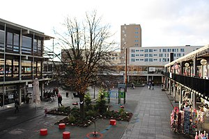
Taastrup
Place in Capital, Denmark
Distance: Approx. 464 meters
Latitude and longitude: 55.65,12.3
Taastrup (or Tåstrup) (Danish pronunciation: [ˈtsʰɒstʁɔp]) is a Danish railway town and suburb of Copenhagen – 18 km west of Copenhagen's city centre. The town forms a twin urban area with neighbouring suburb Høje Taastrup, Taastrup rising since 1859 and Høje Taastrup rising west of the town, since the 1970s. The town/suburb development has engulfed the villages of Taastrup Valby, Høje Taastrup, Kragehave and Klovtofte, although Høje Taastrup still has a preserved village character around Høje Taastrup Church.

Vridsløselille Prison
Former state prison in Copenhagen, Denmark
Distance: Approx. 3476 meters
Latitude and longitude: 55.65975,12.34758333
Vridsløselille Prison (Danish: Vridsløselille Fængsel) is a former state prison located in Albertslund in the western suburbs of Copenhagen in Denmark. It was operated as a state prison from its opening in 1859 to January 2016 and then served as a special departure center for rejected asylum seekers with prison sentences until February 2018. The prison was used for the enforcement of imprisonment and execution of arrests and had a total of 241 inmates.
Herstedvester Prison
Prison in Denmark
Distance: Approx. 3515 meters
Latitude and longitude: 55.6603,12.3478
Herstedvester Prison (Danish: Herstedvester Fængsel) is a prison in Herstedvester, Greater Copenhagen, Denmark, for treatment by the Danish Prison and Probation Service. It houses convicted felons and occasionally people with custody rulings in need of psychiatric assistance and observation. Herstedvester was built in 1935 for the detention and imprisonment of psychopaths.

Taastrup Water Tower
Distance: Approx. 245 meters
Latitude and longitude: 55.6482,12.2977
Taastrup Water Tower is a defunct water tower in Taastrup, a western suburb of Copenhagen, Denmark. The distinctive structure now serves as an observation tower and local landmark, readily visible when approaching Copenhagen from the west along Roskildevej.
Taastrup Teater
Distance: Approx. 1045 meters
Latitude and longitude: 55.6553,12.2956
Taastrup Teater is a theatre in Taastrup in the western suburbs of Copenhagen, Denmark.
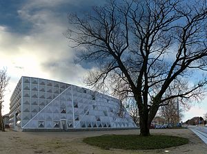
Taastrup Campus (University of Copenhagen)
Distance: Approx. 2671 meters
Latitude and longitude: 55.66944444,12.30694444
Taastrup Campus is a university campus operated by University of Copenhagen (UCPH) in Taastrup on the western outskirts of Copenhagen, Denmark. The campus is home to space-consuming activities of the School of Veterinary Medicine and Animal Science (including the University Teaching Hospital for Large Animals) and the Department of Plant and Environmental Sciences whose Section for Crop Sciences along with experimental fields, greenhouses and an extensive pometum.
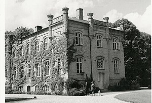
Benzonsdal
Danish historic manor house
Distance: Approx. 3700 meters
Latitude and longitude: 55.62293611,12.25550556
Benzonsdal is a manor house located at Torslunde, south of Taastrup, in the northern part of Ishøj Municipality, some 20 kilometres west of central Copenhagen, Denmark. It has been owned by members of the noble Lerche family since 1853. The main building is from 1856.
Weather in this IP's area
clear sky
12 Celsius
12 Celsius
11 Celsius
13 Celsius
1027 hPa
87 %
1027 hPa
1025 hPa
10000 meters
2.57 m/s
340 degree
7 %
06:45:11
19:26:10