Country:
 Denmark
Region:
City:
Latitude and Longitude:
Time Zone:
Postal Code:
IP information under different IP Channel
ip-api
Country
Region
City
ASN
Time Zone
ISP
Blacklist
Proxy
Latitude
Longitude
Postal
Route
IPinfo
Country
Region
City
ASN
Time Zone
ISP
Blacklist
Proxy
Latitude
Longitude
Postal
Route
MaxMind
Country
Region
City
ASN
Time Zone
ISP
Blacklist
Proxy
Latitude
Longitude
Postal
Route
Luminati
Country
DKASN
Time Zone
Europe/Copenhagen
ISP
Roskilde Kulturservice A/S
Latitude
Longitude
Postal
db-ip
Country
Region
City
ASN
Time Zone
ISP
Blacklist
Proxy
Latitude
Longitude
Postal
Route
ipdata
Country
Region
City
ASN
Time Zone
ISP
Blacklist
Proxy
Latitude
Longitude
Postal
Route
Popular places and events near this IP address

Rødovre Municipality
Municipality in Hovedstaden, Denmark
Distance: Approx. 2568 meters
Latitude and longitude: 55.68138889,12.455
Rødovre Municipality (Danish: Rødovre Kommune) is a municipality (Danish, kommune) in the Capital Region on the island of Zealand in eastern Denmark. Its mayor is Britt Jensen. She is a member of the Social Democrats (Socialdemokraterne) political party who hold a majority of seats in the council.
Islev
Distance: Approx. 1807 meters
Latitude and longitude: 55.7056,12.44
Islev is a suburb, located approximately 10 km west of central Copenhagen, Denmark. The suburb consists of single-family detached houses and a commercial area. The suburb is connected to Copenhagen by the S-train.
Hvissinge
Distance: Approx. 1622 meters
Latitude and longitude: 55.67916667,12.41861111
Hvissinge (or Hvessinge on some maps, though not in local signage) is a suburb approximately 13 km west of central Copenhagen. Originally a small village, the town grew quickly in the 1970s along with Glostrup. It is part of Glostrup Municipality and situated 2 km north east of the city centre.

Rødovre
Place in Capital, Denmark
Distance: Approx. 2568 meters
Latitude and longitude: 55.68138889,12.455
Rødovre is a town in eastern Denmark, seat of the Rødovre Municipality, in the Region Hovedstaden. The town's population 1 January 2019 was 39,907, and in addition 145 persons had no fixed address, which made up a total of 40,052 in the municipality as a whole. Rødovre is part of the urban area of Copenhagen.
Rødovre Town Hall
Listed building in Rødovre, Denmark
Distance: Approx. 2434 meters
Latitude and longitude: 55.68166667,12.45277778
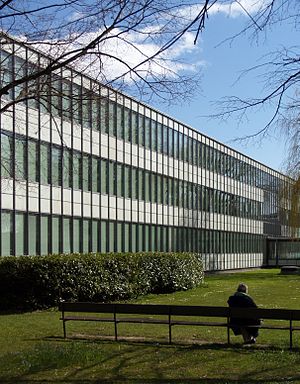
Rødovre Town Hall (Danish: Rødovre Rådhus) is located at the centre of Rødovre, a municipality some 9 km (5 mi) to the west of Copenhagen's city centre. Completed in 1956, it was designed by the Danish architect Arne Jacobsen. A fine example of the international architecture trends of the 1950s, it was inspired by the General Motors Technical Center to the north of Detroit.
Statens Pædagogiske Forsøgscenter
Distance: Approx. 1548 meters
Latitude and longitude: 55.70532778,12.43394722
National Innovative Centre (Danish: Statens Pædagogiske Forsøgscenter) was a state school located in Islev, Denmark. The school was established in 1964 by Danish education minister K. Helveg Petersen to develop teaching innovations, and share the results of their work with schools across Denmark. The school had to close in 2007 due to political conflicts.

Vestvolden
Distance: Approx. 2408 meters
Latitude and longitude: 55.67222222,12.425
Vestvolden (Danish for 'the Western Rampart') is a rampart complex west of Copenhagen, Denmark. Stretching approximately 14 kilometres (9 mi) from Avedøre in the south to Utterslev Mose in the north, it is part of the last generation of land fortifications of the city. Built in the period 1888–1892 by up to 2,000 workers, it was the largest construction project of its time in Denmark.

Rødovre Centrum
Shopping mall in Copenhagen, Denmark
Distance: Approx. 2773 meters
Latitude and longitude: 55.6782,12.455
Rødovre Centrum is a shopping center and mixed-use development situated in Rødovre in the western suburbs of Copenhagen, Denmark. It has a total area of 150,000 square metres of which 44,000 square metres are retail space. The shopping center consists of more than a hundred shops and includes a Føtex supermarket and a Magasin du Nord.
Ejby, Glostrup Municipality
Distance: Approx. 802 meters
Latitude and longitude: 55.6961,12.40835
Ejby is a suburb in greater Copenhagen in Glostrup Municipality, lying between Glostrup and Skovlunde. It is located about 13 km (8.1 mi) from the city center of Copenhagen. Ejby will have a station on the Greater Copenhagen Light Rail line which is due to open in 2025.
Danish Headache Center
Distance: Approx. 2908 meters
Latitude and longitude: 55.672523,12.393272
The Danish Headache Center (DHC) is an academic medical center at Rigshospitalet in Copenhagen, Denmark. It was founded in 2001 and currently employs more than 100 health care professionals, scientists and administrative staff. The DHC focuses on health care services, education, and research related to headache disorders and facial pains.

Rødovre Skøjte Arena
Distance: Approx. 1969 meters
Latitude and longitude: 55.68055556,12.44138889
Rødovre Skøjte Arena (as a result of a name sponsorship also known as Rødovre Centrum Arena), is an ice hockey arena in Rødovre, Greater Copenhagen. The arena, inaugurated on 6 February 1995, is home to both the Rødovre Mighty Bulls and the parent club RSIK and is used for both figure skating and ice hockey. The arena replaced the old Rødovre Ice Skating Hall (Rødovre Skøjtehal) with the nickname Kostalden (cow shed), which was in the northeastern part of Rødovre at Rødovrevej.
Espelundens Idrætsanlæg
Football stadium in Denmark
Distance: Approx. 2212 meters
Latitude and longitude: 55.67472222,12.43083333
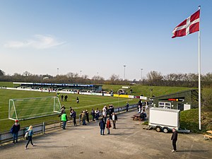
Espelundens Idrætsanlæg is an association football facility in Rødovre, Denmark. It is the home stadium of 2nd Division club Boldklubben Avarta and lower league side Islev Boldklub, who have their club house 100 m north of the stadium. The facility consists of the stadium, which has a capacity of 6,000 of which 460 are seated, the ground also includes a cafeteria, seven additional grass pitches, three gravel pitches, six mini pitches and a roller hockey rink.
Weather in this IP's area
clear sky
13 Celsius
12 Celsius
11 Celsius
15 Celsius
1027 hPa
83 %
1027 hPa
1025 hPa
10000 meters
4.12 m/s
20 degree
7 %
06:44:40
19:25:43