Country:
 Poland
Region:
City:
Latitude and Longitude:
Time Zone:
Postal Code:
IP information under different IP Channel
ip-api
Country
Region
City
ASN
Time Zone
ISP
Blacklist
Proxy
Latitude
Longitude
Postal
Route
IPinfo
Country
Region
City
ASN
Time Zone
ISP
Blacklist
Proxy
Latitude
Longitude
Postal
Route
MaxMind
Country
Region
City
ASN
Time Zone
ISP
Blacklist
Proxy
Latitude
Longitude
Postal
Route
Luminati
Country
PLRegion
32
City
swinoujscie
ASN
Time Zone
Europe/Warsaw
ISP
Arelion Sweden AB
Latitude
Longitude
Postal
db-ip
Country
Region
City
ASN
Time Zone
ISP
Blacklist
Proxy
Latitude
Longitude
Postal
Route
ipdata
Country
Region
City
ASN
Time Zone
ISP
Blacklist
Proxy
Latitude
Longitude
Postal
Route
Popular places and events near this IP address

Świnoujście
City in West Pomerania, Poland
Distance: Approx. 1543 meters
Latitude and longitude: 53.91666667,14.25
Świnoujście (Polish: [ɕfinɔˈujɕt͡ɕɛ] ; German: Swinemünde [ˌsviːnəˈmʏndə]; Low German: Swienemünn; all three meaning "Świna [river] mouth"; Kashubian: Swina) is a city in Western Pomerania and seaport on the Baltic Sea and Szczecin Lagoon, located in the extreme north-west of Poland. Situated mainly on the islands of Usedom and Wolin, it also occupies smaller islands. The largest is Karsibór island, once part of Usedom, now separated by the Piast Canal dug in the late 19th century to facilitate ship access to Szczecin.

Świna
River in Poland
Distance: Approx. 2657 meters
Latitude and longitude: 53.9225,14.28111111
The Świna (German: Swine; Pomeranian: Swina) is a channel in northwest Poland, between 2 and 4 km (1.2 and 2.5 miles) from the German border. It connects the Szczecin Lagoon with the Baltic Sea separating the islands of Uznam (German: Usedom) and Wolin (German: Wollin). It is a part of the Oder estuary, and carries about 75% of that river's waterflow (of the remainder, Peenestrom carries 15% and Dziwna 10%).

German auxiliary cruiser Orion
German commerce raider
Distance: Approx. 5471 meters
Latitude and longitude: 53.95,14.28333333
Orion (HSK-1) was an auxiliary cruiser of Nazi Germany's Kriegsmarine which operated as a merchant raider in World War II. Blohm & Voss built her in Hamburg in 1930–31 as the cargo ship Kurmark. The navy requisitioned her at the start of World War II, had her converted into the auxiliary cruiser Orion, and commissioned her on 9 December 1939. Known to the Kriegsmarine as Schiff 36, her Royal Navy designation was Raider A. She was named after the constellation Orion.
German submarine U-803
German World War II submarine
Distance: Approx. 2282 meters
Latitude and longitude: 53.91666667,14.28333333
German submarine U-803 was a Type IXC/40 U-boat built for Nazi Germany's Kriegsmarine during World War II at Bremerhaven.

Świnoujście Lighthouse
Lighthouse in Poland
Distance: Approx. 2285 meters
Latitude and longitude: 53.915979,14.28434
Świnoujście Lighthouse (Polish: Latarnia Morska Świnoujście) is an active lighthouse in Świnoujście, Poland. At a height of 212 feet (65 m) it is the fifteenth tallest "traditional lighthouse" in the world, as well as the tallest brick lighthouse, and the tallest in Poland. It is located on the east bank of the river Świna just inside the entrance.

Wolgastsee
Distance: Approx. 5467 meters
Latitude and longitude: 53.91694444,14.17666667
Wolgastsee is a lake in Usedom, Mecklenburg-Vorpommern, Germany. At an elevation of -0.6 m, its surface area is 0.47 km2.
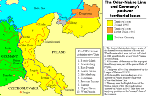
Oder–Neisse line
German-Polish border since the end of World War II
Distance: Approx. 3334 meters
Latitude and longitude: 53.92630556,14.22402778
The Oder–Neisse line (German: Oder-Neiße-Grenze, Polish: granica na Odrze i Nysie Łużyckiej) is an unofficial term for the modern border between Germany and Poland. The line generally follows the Oder and Lusatian Neisse rivers, meeting the Baltic Sea in the north. A small portion of Polish territory does fall west of the line, including the cities of Szczecin and Świnoujście (German: Stettin and Swinemünde).

Golm War Cemetery
Cemetery in Kamminke, Germany
Distance: Approx. 4344 meters
Latitude and longitude: 53.88333333,14.2
The Golm War Cemetery (German: Kriegsgräberstätte Golm) is a World War II cemetery near the village of Kamminke close to the German-Polish border on the island of Usedom maintained and managed by the German War Graves Commission. The cemetery is the largest war cemetery in Mecklenburg-Vorpommern and one of the largest in Germany.
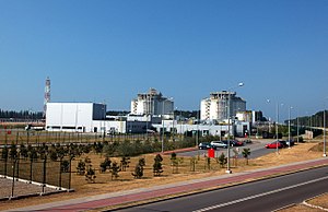
Świnoujście LNG terminal
LNG terminal in Poland
Distance: Approx. 2568 meters
Latitude and longitude: 53.90916667,14.29472222
The Świnoujście LNG terminal (also referred as Terminal LNG in Świnoujście, Polskie LNG Baltic LNG, or gazoport) is a liquefied natural gas (LNG) import terminal at Świnoujście, in the extreme north-west of Poland near the Polish-German border. The LNG terminal is operated by Polskie LNG S.A., a subsidiary of Gaz-System. The cornerstone for construction was laid on 23 March 2011 and it took its first LNG delivery on 11 December 2015.

Stawa Młyny
Polish lighthouse
Distance: Approx. 2876 meters
Latitude and longitude: 53.926204,14.277409
Stawa Młyny (German: Mühlenbake) is a beacon in the shape of a windmill in Świnoujście, West Pomeranian Voivodeship; in Poland. The beacon acts as a signal for vessels entering the Port of Świnoujście, from the Baltic Sea.
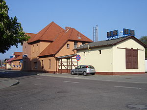
Świnoujście railway station
Railway station in Świnoujście, Poland
Distance: Approx. 661 meters
Latitude and longitude: 53.9048,14.2666
Świnoujście railway station is the principal railway station in the town of Świnoujście, in the West Pomeranian Voivodeship, Poland. The station and is located on the Szczecin Dąbie–Świnoujście Port railway. The train services are operated by PKP Intercity and Polregio.
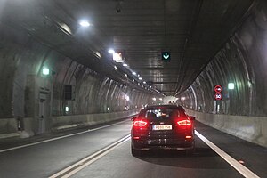
Świnoujście Tunnel
Underwater road tunnel in Poland
Distance: Approx. 1035 meters
Latitude and longitude: 53.89416667,14.255
The Świnoujście Tunnel (Polish: Tunel pod Świną) is a tunnel beneath the Świna Channel in Świnoujście, Poland, connecting the islands of Uznam and Wolin which separate the Szczecin Lagoon from the Baltic Sea in north western Poland. It constitutes the only fixed link between two parts of the city and subsequently between the rest of the country and the center of Świnoujście which prior to the tunnels opening in 2023 was accessible only by ferry. The tunnel carries route DK 93 of the Polish national roads network.
Weather in this IP's area
overcast clouds
11 Celsius
10 Celsius
10 Celsius
11 Celsius
1017 hPa
76 %
1017 hPa
1017 hPa
10000 meters
4.31 m/s
6.82 m/s
134 degree
92 %
07:36:36
17:59:13