Country:
 Germany
Region:
City:
Latitude and Longitude:
Time Zone:
Postal Code:
IP information under different IP Channel
ip-api
Country
Region
City
ASN
Time Zone
ISP
Blacklist
Proxy
Latitude
Longitude
Postal
Route
IPinfo
Country
Region
City
ASN
Time Zone
ISP
Blacklist
Proxy
Latitude
Longitude
Postal
Route
MaxMind
Country
Region
City
ASN
Time Zone
ISP
Blacklist
Proxy
Latitude
Longitude
Postal
Route
Luminati
Country
DEASN
Time Zone
Europe/Berlin
ISP
Arelion Sweden AB
Latitude
Longitude
Postal
db-ip
Country
Region
City
ASN
Time Zone
ISP
Blacklist
Proxy
Latitude
Longitude
Postal
Route
ipdata
Country
Region
City
ASN
Time Zone
ISP
Blacklist
Proxy
Latitude
Longitude
Postal
Route
Popular places and events near this IP address

Marburg
Town in Hesse, Germany
Distance: Approx. 2138 meters
Latitude and longitude: 50.81,8.77083333
Marburg (German pronunciation: [ˈmaːɐ̯bʊʁk] or [ˈmaʁbʊʁk] ) is a university town in the German federal state (Bundesland) of Hesse, capital of the Marburg-Biedenkopf district (Landkreis). The town area spreads along the valley of the river Lahn and has a population of approximately 76,000. Having been awarded town privileges in 1222, Marburg served as capital of the landgraviate of Hessen-Marburg during periods of the 15th to 17th centuries.
Marburg-Biedenkopf
District in Hesse, Germany
Distance: Approx. 663 meters
Latitude and longitude: 50.786173,8.771918
Marburg-Biedenkopf is a Kreis (district) in the west of Hesse, Germany. Neighboring districts are Waldeck-Frankenberg, Schwalm-Eder, Vogelsbergkreis, Gießen, Lahn-Dill, Siegen-Wittgenstein.

Gymnasium Philippinum
School in Marburg, Hesse, Germany
Distance: Approx. 1271 meters
Latitude and longitude: 50.80083333,8.75722222
Gymnasium Philippinum or Philippinum High School is an almost 500-year-old secondary school in Marburg, Hesse, Germany.

Elisabethschule Marburg
Distance: Approx. 1528 meters
Latitude and longitude: 50.8,8.75
The Elisabethschule is a Gymnasium in Marburg.
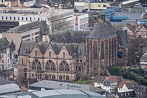
University Church of Marburg
Distance: Approx. 1938 meters
Latitude and longitude: 50.80805556,8.77194444
The University Church of Marburg is a 13th-century, asymmetric, two-aisled hall church in Marburg, Hesse.

Marburg Süd station
Railway station in Marburg, Germany
Distance: Approx. 513 meters
Latitude and longitude: 50.795,8.76277778
Marburg Süd railway station (German: Marburg Südbahnhof) is a train station in the south of Marburg in Hesse on the Main-Weser Railway.

Cappel, Marburg
Borough of Marburg in Hesse, Germany
Distance: Approx. 854 meters
Latitude and longitude: 50.78333333,8.76666667
Cappel (German pronunciation: [ˈkapl̩] ) is a borough (Ortsbezirk) of Marburg in Hesse.

Ockershausen
Borough of Marburg in Hesse, Germany
Distance: Approx. 1648 meters
Latitude and longitude: 50.80083333,8.74888889
Ockershausen is a borough (Ortsbezirk) of Marburg in Hesse.

Richtsberg
Borough of Marburg in Hesse, Germany
Distance: Approx. 1466 meters
Latitude and longitude: 50.78333333,8.78333333
Richtsberg is a borough (Ortsbezirk) of Marburg in Hesse.
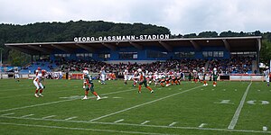
Georg-Gaßmann-Stadion
Distance: Approx. 1122 meters
Latitude and longitude: 50.797775,8.75460278
The Georg-Gaßmann-Stadion is a multi-purpose stadium in the district of Ockershausen in Marburg, Germany, named after the former politician and mayor of the city, Georg Gaßmann. The stadium, opened in 1967, is primarily used by the American football team Marburg Mercenaries, who play in the German Football League. VfB Marburg, the city's highest ranked association football team, also use the ground for friendlies and cup games against higher-ranked opponents.

Stadion an der Gisselberger Straße
Distance: Approx. 779 meters
Latitude and longitude: 50.79593333,8.75855278
The Stadion an der Gisselberger Straße is a football stadium in the district of Ockershausen in Marburg, Germany. VfB Marburg play most of their home league games here at the Gisselberger Straße stadium. The only exceptions being some cup games and friendlies against higher division clubs at the adjacent 12,000 capacity Georg-Gaßmann-Stadion.

Hessisches Staatsarchiv Marburg
German archive
Distance: Approx. 1445 meters
Latitude and longitude: 50.8038,8.763
The Hessisches Staatsarchiv Marburg (HStAM, "Hessian State Archives in Marburg") is one of the three archives of the Hessisches Landesarchiv and is based in Marburg upon Lahn.
Weather in this IP's area
light rain
14 Celsius
14 Celsius
13 Celsius
15 Celsius
1014 hPa
95 %
1014 hPa
992 hPa
10000 meters
1.76 m/s
1.82 m/s
178 degree
100 %
07:53:07
18:26:36