Country:
 Poland
Region:
City:
Latitude and Longitude:
Time Zone:
Postal Code:
IP information under different IP Channel
ip-api
Country
Region
City
ASN
Time Zone
ISP
Blacklist
Proxy
Latitude
Longitude
Postal
Route
IPinfo
Country
Region
City
ASN
Time Zone
ISP
Blacklist
Proxy
Latitude
Longitude
Postal
Route
MaxMind
Country
Region
City
ASN
Time Zone
ISP
Blacklist
Proxy
Latitude
Longitude
Postal
Route
Luminati
Country
PLRegion
24
City
jastrzebiezdroj
ASN
Time Zone
Europe/Warsaw
ISP
Arelion Sweden AB
Latitude
Longitude
Postal
db-ip
Country
Region
City
ASN
Time Zone
ISP
Blacklist
Proxy
Latitude
Longitude
Postal
Route
ipdata
Country
Region
City
ASN
Time Zone
ISP
Blacklist
Proxy
Latitude
Longitude
Postal
Route
Popular places and events near this IP address

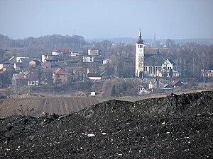
Jastrzębie-Zdrój
Place in Silesian Voivodeship, Poland
Distance: Approx. 1002 meters
Latitude and longitude: 49.95,18.58333333
Jastrzębie-Zdrój ([jastˈʂɛmbʲɛ ˈzdruj] ; German: Bad Königsdorff-Jastrzemb, originally Jastrzemb, Czech: Lázně Jestřebí; Silesian: Jastrzymbie-Zdroj) is a city in south Poland with 86,632 inhabitants (2021). Its name comes from the Polish words jastrząb ("hawk") and zdrój ("spa" or "spring"). From 1861 until the 20th century, it was a spa village situated in Upper Silesia.

Mszana
Village in Silesian Voivodeship, Poland
Distance: Approx. 4311 meters
Latitude and longitude: 49.96916667,18.51555556
Mszana [ˈmʂana] is a village in Wodzisław County, Silesian Voivodeship, in southern Poland. It is the seat of the gmina (administrative district) called Gmina Mszana. It lies approximately 6 kilometres (4 mi) south-east of Wodzisław Śląski and 47 km (29 mi) south-west of the regional capital Katowice.

Gmina Mszana
Gmina in Silesian Voivodeship, Poland
Distance: Approx. 4311 meters
Latitude and longitude: 49.96916667,18.51555556
Gmina Mszana is a rural gmina (administrative district) in Wodzisław County, Silesian Voivodeship, in southern Poland. Its seat is the village of Mszana, which lies approximately 6 kilometres (4 mi) south-east of Wodzisław Śląski and 47 km (29 mi) south-west of the regional capital Katowice. The gmina also contains the villages of Gogołowa and Połomia.
Połomia, Wodzisław County
Village in Silesian Voivodeship, Poland
Distance: Approx. 4304 meters
Latitude and longitude: 49.99,18.55527778
Połomia [pɔˈwɔmja] is a village in the administrative district of Gmina Mszana, within Wodzisław County, Silesian Voivodeship, in southern Poland. It lies approximately 4 kilometres (2 mi) north-east of Mszana, 8 km (5 mi) east of Wodzisław Śląski, and 43 km (27 mi) south-west of the regional capital Katowice.
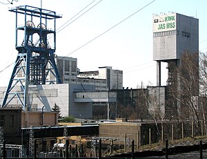
Jas-Mos Coal Mine
Mine in Jastrzębie-Zdrój, Silesian Voivodeship, Poland
Distance: Approx. 1665 meters
Latitude and longitude: 49.96694444,18.56388889
The Jas-Mos coal mine is a large mine in the south of Poland in Jastrzębie-Zdrój, Silesian Voivodeship, 260 km south-west of the capital, Warsaw. Jas-Mos represents one of the largest coal reserve in Poland having estimated reserves of 34.1 million tonnes of coal. The annual coal production is around 3.95 million tonnes.

Zofiówka Coal Mine
Mine in Jastrzębie-Zdrój, Silesian Voivodeship, Poland
Distance: Approx. 4321 meters
Latitude and longitude: 49.9675,18.62555556
The Zofiówka coal mine is a large mine in the south of Poland in Jastrzębie-Zdrój, Silesian Voivodeship, 307 km south-west of the capital, Warsaw. Zofiówka represents one of the largest coal reserve in Poland having estimated reserves of 87 million tonnes of coal. The annual coal production is around 3.7 million tonnes.

Gmyrdek
River in Poland
Distance: Approx. 2162 meters
Latitude and longitude: 49.937213,18.588526
Gmyrdek is a river of Poland, a tributary of the river Ruptawka near Jastrzębie-Zdrój.

Kolejówka
River in Poland
Distance: Approx. 2171 meters
Latitude and longitude: 49.9689,18.5535
Kolejówka is a river of Poland, a tributary of the Szotkówka near Mszana.

Jastrzębie-Zdrój Stadium
Distance: Approx. 3024 meters
Latitude and longitude: 49.95,18.61194444
The Jastrzębie-Zdrój Stadium is a football stadium in Jastrzębie-Zdrój, Poland. The stadium is used by the GKS Jastrzębie. The stadium has 6,800 seats; the areas of the stadium without seats are not used.

Prstná
Village in Karviná District, Czech Republic
Distance: Approx. 4544 meters
Latitude and longitude: 49.91277778,18.55527778
Prstná (Polish: Piers(t)na, German: Piersna) is a village in Karviná District, Moravian-Silesian Region, Czech Republic. It was a separate municipality but became administratively a part of Petrovice u Karviné in 1952. The name of the village is topographic in origin denoting dust, soil.

Ruptawa
Polanski village
Distance: Approx. 4013 meters
Latitude and longitude: 49.922716,18.601444
Ruptawa (German: Ruptau) is a sołectwo in the south of Jastrzębie-Zdrój, Silesian Voivodeship, southern Poland. It was an independent village but became administratively part of Jastrzębie-Zdrój in 1975. It has an area of 1522,51 ha and on December 31, 2012 it had 3,741 inhabitants.

Moszczenica, Jastrzębie-Zdrój
Sołectwo of Jastrzębie-Zdrój in Silesian Voivodeship, Poland
Distance: Approx. 4013 meters
Latitude and longitude: 49.922716,18.601444
Moszczenica (German: Moschczenitz) is a sołectwo in the south west of Jastrzębie-Zdrój, Silesian Voivodeship, southern Poland. It was an independent village but became administratively part of Jastrzębie-Zdrój in 1975. It has na area of 803 ha and on December 31, 2012 it had 3,078 inhabitants.
Weather in this IP's area
clear sky
12 Celsius
11 Celsius
11 Celsius
13 Celsius
1021 hPa
67 %
1021 hPa
992 hPa
10000 meters
2.61 m/s
4.31 m/s
110 degree
2 %
07:12:31
17:48:48