Country:
 Poland
Region:
City:
Latitude and Longitude:
Time Zone:
Postal Code:
IP information under different IP Channel
ip-api
Country
Region
City
ASN
Time Zone
ISP
Blacklist
Proxy
Latitude
Longitude
Postal
Route
IPinfo
Country
Region
City
ASN
Time Zone
ISP
Blacklist
Proxy
Latitude
Longitude
Postal
Route
MaxMind
Country
Region
City
ASN
Time Zone
ISP
Blacklist
Proxy
Latitude
Longitude
Postal
Route
Luminati
Country
PLRegion
30
City
poznan
ASN
Time Zone
Europe/Warsaw
ISP
Arelion Sweden AB
Latitude
Longitude
Postal
db-ip
Country
Region
City
ASN
Time Zone
ISP
Blacklist
Proxy
Latitude
Longitude
Postal
Route
ipdata
Country
Region
City
ASN
Time Zone
ISP
Blacklist
Proxy
Latitude
Longitude
Postal
Route
Popular places and events near this IP address

Poznań
City in Greater Poland Voivodeship, Poland
Distance: Approx. 349 meters
Latitude and longitude: 52.40833333,16.93361111
Poznań (Polish: [ˈpɔznaɲ] ) is a city on the River Warta in west Poland, within the Greater Poland region. The city is an important cultural and business centre, and one of Poland's most populous regions with many regional customs such as Saint John's Fair (Jarmark Świętojański), traditional Saint Martin's croissants and a local dialect. Among its most important heritage sites are the Renaissance Old Town, Town Hall and Gothic Cathedral.

St. John Cantius High School, Poznań
High school in Poznań, Poland
Distance: Approx. 114 meters
Latitude and longitude: 52.40444444,16.93277778
St. John Cantius School is a high school in Poznań, Poland named after the scholar and theologian St. John Cantius.

Poznań Town Hall
Distance: Approx. 380 meters
Latitude and longitude: 52.40861111,16.93416667
Poznań Town Hall (Polish: ratusz w Poznaniu) is a historic city hall in the city of Poznań, Poland, located at the Poznań Old Town in the centre of the Old Market Square. It used to serve as the seat of local government until 1939, and now houses a museum. The town hall was originally built in the late 13th century following the founding of the medieval city in 1253; it was rebuilt in roughly its present-day form, in mannerist style, with an ornate loggia, by Giovanni Battista di Quadro from 1550–1560.

Pranger of Poznań
Monument in Poland
Distance: Approx. 351 meters
Latitude and longitude: 52.40833333,16.93444444
The Pranger of Poznań is found near the north-east corner of the Town Hall, not far from the Prozerpina Fountain. It is an eight-sided, late-Gothic column, on the summit of which stands a statue of an executioner in a Crusader's outfit holding a raised sword. The current pranger is a copy made by Marcin Rożek in 1925.

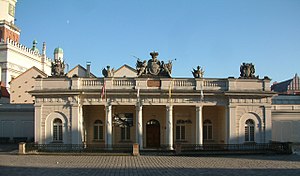
Działyński Palace
Distance: Approx. 378 meters
Latitude and longitude: 52.408507,16.932615
Działyński Palace in Poznań, Poland is a Baroque palace built in 1773 to 1776. The building features a rich stucco-decorated interior of its "Red Hall" and a classicist façade decorated with sculptures. The palace serves as one of the locations of Kórnik Library today.
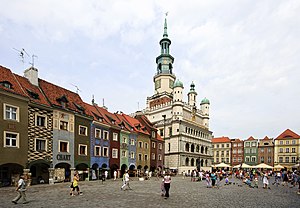
Poznań Old Town
Neighbourhood in Poznań, Poland
Distance: Approx. 351 meters
Latitude and longitude: 52.40833333,16.93444444
Poznań Old Town is the centermost neighbourhood of the city of Poznań in western Poland, covering the area of the once walled medieval city of Poznań. It is called Stare Miasto in Polish, although that name may also refer to the wider administrative district of Stare Miasto, which extends to most of the city centre and northern parts of the city. The Old Town is centred on Stary Rynek, the Old Market Square where the historic Poznań Town Hall (Ratusz) stands.

Institute for Physico-Medical Research
Distance: Approx. 471 meters
Latitude and longitude: 52.407597,16.928179
The Institute of Physico-Medical Research (polish: Instytut Badań Fizykomedycznych, IBF), is a Polish research unit that emerged in 1991 as a Research and Development Department of Primax Medic Research, Innovative and Development Company Ltd. It cooperates with specialists from renowned scientific and clinical institutions and has the Scientific Council . Its activities cover developing innovative technologies used in medicine and biotechnology.

Saint Mary Magdalene High School in Poznań
School in Poznań, Greater Poland Province, Poland
Distance: Approx. 382 meters
Latitude and longitude: 52.40333333,16.93861111
Saint Mary Magdalene High School in Poznań (Polish: Liceum Ogólnokształcące św. Marii Magdaleny; Latin: Ad sanctam Mariam Magdalenam; colloquially simply as Marynka) is one of the oldest and one of the most prestigious and selective high schools in Poland. School is noted for its alumni, its academics, and the large number of graduates attending prestigious universities.

Poznań Fara
Church in Poznań, Poland
Distance: Approx. 103 meters
Latitude and longitude: 52.40611111,16.93416667
The Basilica of Our Lady of Perpetual Help in Poznań Fara (Polish: Fara Poznańska), also informally known as the Poznan Fara, is a Catholic minor basilica located in Poznań Old Town district of Poland. The famed shrine is dedicated to the Blessed Virgin Mary and is one of the city's most recognizable historical landmarks, the most important Christian temple alongside the Poznań Cathedral and the finest example of Baroque architecture preserved within the country. Its full name is the Basilica of Our Lady of Perpetual Help, Saints Mary Magdalene and Stanislaus of Szczepanów.

Poznań Croissant Museum
Distance: Approx. 360 meters
Latitude and longitude: 52.40837306,16.93488889
Rogalowe Muzeum Poznania is a museum of St. Martin's croissants, located in Poznań, at 41 Stary Rynek. The museum is dedicated to the tradition of baking croissants, already 150 years old.
Wielkopolska Museum of Independence
Polish history museum
Distance: Approx. 349 meters
Latitude and longitude: 52.4083,16.9331
Wielkopolska Museum of Independence is a museum, a local cultural institution organized by the city of Poznań. The scope of the museum's activities includes collecting and making available collections on the independence uprisings and organic work during the partitions, the period of the Second Republic of Poland, fighting and martyrdom during World War II, as well as protests and opposition activities in the years 1945-1989. Before the name was changed, the museum was known as the Wielkopolska Museum of the Fight for Independence.

Poznań Goats
Distance: Approx. 380 meters
Latitude and longitude: 52.40861111,16.93416667
Poznań Goats is one of the tourist attractions of Poznań. The mechanical goats butt heads every day at 12:00 on the tower of the Poznań City Hall.
Weather in this IP's area
clear sky
27 Celsius
27 Celsius
26 Celsius
27 Celsius
1013 hPa
50 %
1013 hPa
1007 hPa
10000 meters
4.12 m/s
120 degree
06:15:32
19:24:33