Country:
 Switzerland
Region:
City:
Latitude and Longitude:
Time Zone:
Postal Code:
IP information under different IP Channel
ip-api
Country
Region
City
ASN
Time Zone
ISP
Blacklist
Proxy
Latitude
Longitude
Postal
Route
IPinfo
Country
Region
City
ASN
Time Zone
ISP
Blacklist
Proxy
Latitude
Longitude
Postal
Route
MaxMind
Country
Region
City
ASN
Time Zone
ISP
Blacklist
Proxy
Latitude
Longitude
Postal
Route
Luminati
Country
CHRegion
zh
City
glattbrugg
ASN
Time Zone
Europe/Zurich
ISP
Arelion Sweden AB
Latitude
Longitude
Postal
db-ip
Country
Region
City
ASN
Time Zone
ISP
Blacklist
Proxy
Latitude
Longitude
Postal
Route
ipdata
Country
Region
City
ASN
Time Zone
ISP
Blacklist
Proxy
Latitude
Longitude
Postal
Route
Popular places and events near this IP address
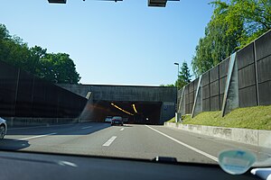
Bubenholz Tunnel
Distance: Approx. 648 meters
Latitude and longitude: 47.43305556,8.57111111
The Bubenholz Tunnel is a motorway tunnel in the Swiss canton of Zurich. It forms part of the A51 motorway, which links the A1 motorway with Zurich Airport. The tunnel is 550 metres (1,800 ft) long.

Opfikon
Municipality in Switzerland in Zürich
Distance: Approx. 327 meters
Latitude and longitude: 47.43333333,8.56666667
Opfikon (German pronunciation: [ˈɔpfikoːn]; in the local Swiss German dialect: [ˈopfikxə]) is the name of a municipality in the Swiss canton of Zürich, located in the district of Bülach.

Swiss Arena
Sports arena in Zürich, Switzerland
Distance: Approx. 1779 meters
Latitude and longitude: 47.442,8.584
SWISS Arena is an indoor arena in Kloten, Switzerland. It is primarily used for ice hockey and is the home arena of the Kloten Flyers. In 2008 the Eishalle Schluefweg was renamed Kolping Arena due to a sponsoring deal.

Glatt Valley
River Valley in Switzerland
Distance: Approx. 2038 meters
Latitude and longitude: 47.41666667,8.56666667
The Glatt Valley (German: Glattal or Glatttal) is a region and a river valley in the canton of Zürich in Switzerland.

Zürich Airport railway station
Railway station serving Zurich Airport in Switzerland
Distance: Approx. 1735 meters
Latitude and longitude: 47.45038194,8.56236694
Zurich Airport railway station (German: Bahnhof Zürich Flughafen) is a railway station serving Zurich Airport in Switzerland. The station is located underneath the Airport Centre, the main ground-side passenger terminal of the airport, which is in the canton of Zurich and the municipality of Kloten.

Glattpark
Construction project on Opfikon, Switzerland
Distance: Approx. 1406 meters
Latitude and longitude: 47.4222,8.5616
Glattpark is a large construction project in Switzerland that took shape in Opfikon, close to the border to Zürich. As part of the construction project a new neighbourhood was built by 2020; it is designed to provide room for 7,000 residents and about the same number of jobs. Some of the favourable locational factors used to market the area are the direct proximity to the city of Zürich, where similar construction projects are being realized in Oerlikon and Seebach.

Leutschenpark
Public park in the northern Zürich neighbourhood of Leutschenbach
Distance: Approx. 1922 meters
Latitude and longitude: 47.41805556,8.55666667
Leutschenpark is a public park in the northern Zürich neighbourhood of Leutschenbach. As the main park, the 161,459 ft² Leutschenpark and its flowing shapes bring a new accent to the district which was previously characterized by industry and service buildings. The former industrial and commercial district to the north of Zürich is being transformed into an attractive, mixed neighbourhood for living and working.
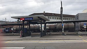
Glattbrugg railway station
Railway station in the Glattbrugg area of the Swiss municipality of Opfikon
Distance: Approx. 538 meters
Latitude and longitude: 47.43080556,8.55888889
Glattbrugg railway station (German: Bahnhof Glattbrugg) is a railway station in Switzerland, in the Glattbrugg area of the municipality of Opfikon. The station is located on the main line of the Oerlikon–Bülach line and is an interchange point between the Zürich S-Bahn and the Stadtbahn Glattal light rail system. The station is served by S-Bahn lines S3, S9 and S15, and by Zürich tram routes 10 and 12, operating on behalf of the Stadtbahn Glattal.
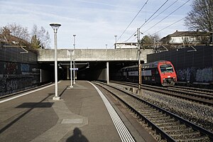
Opfikon railway station
Railway station in Switzerland
Distance: Approx. 547 meters
Latitude and longitude: 47.42995,8.56175806
Opfikon is a railway station in Switzerland, in the municipality of Opfikon. The station is served by Zürich S-Bahn line S7. Opfikon station is some 250 metres (820 ft) walk from Glattbrugg station on S-Bahn line S5 and the Stadtbahn Glattal.

Kloten railway station
Railway station in Kloten, Switzerland
Distance: Approx. 2123 meters
Latitude and longitude: 47.4482,8.582972
Kloten is a railway station in the Swiss canton of Zurich and municipality of Kloten. The station is located on the Zurich to Winterthur line and is an intermediate stop on Zurich S-Bahn line S7. Although the station is situated only 1.5 kilometres (0.93 mi) from the main terminal of Zurich Airport, it has been bypassed by the opening, in 1980, of a new line directly serving the Zürich Airport railway station in the basement of that terminal.

Kloten Balsberg railway station
Railway station in Switzerland
Distance: Approx. 995 meters
Latitude and longitude: 47.441985,8.570763
Kloten Balsberg is a railway station in the Swiss canton of Zürich and municipality of Kloten. The station is located on a variant of the multi-stranded Zürich–Winterthur railway line and is served by S-Bahn line S7. It is an interchange point between the Zürich S-Bahn and the Stadtbahn Glattal light rail system, which serves an elevated tram stop, adjacent to the station and connected directly to the station platform by an elevated walkway.
Sevanan Business School
Distance: Approx. 1906 meters
Latitude and longitude: 47.4179,8.5588
Sevanan Business School was a Swiss private business school. It offered management courses at undergraduate level and Masters level, accredited to London School of Marketing. Sevanan Business School provided international programs in business management & marketing management.
Weather in this IP's area
fog
12 Celsius
12 Celsius
11 Celsius
14 Celsius
1016 hPa
91 %
1016 hPa
966 hPa
10000 meters
1.54 m/s
150 degree
49 %
07:48:48
18:32:33