Country:
 Germany
Region:
City:
Latitude and Longitude:
Time Zone:
Postal Code:
IP information under different IP Channel
ip-api
Country
Region
City
ASN
Time Zone
ISP
Blacklist
Proxy
Latitude
Longitude
Postal
Route
IPinfo
Country
Region
City
ASN
Time Zone
ISP
Blacklist
Proxy
Latitude
Longitude
Postal
Route
MaxMind
Country
Region
City
ASN
Time Zone
ISP
Blacklist
Proxy
Latitude
Longitude
Postal
Route
Luminati
Country
DEASN
Time Zone
Europe/Berlin
ISP
Host Europe GmbH
Latitude
Longitude
Postal
db-ip
Country
Region
City
ASN
Time Zone
ISP
Blacklist
Proxy
Latitude
Longitude
Postal
Route
ipdata
Country
Region
City
ASN
Time Zone
ISP
Blacklist
Proxy
Latitude
Longitude
Postal
Route
Popular places and events near this IP address
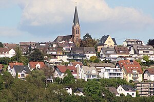
Sayn
Distance: Approx. 809 meters
Latitude and longitude: 50.43833333,7.57638889
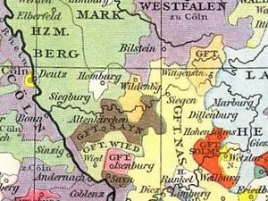
Sayn was a small German county of the Holy Roman Empire which, during the Middle Ages, existed within what is today Rheinland-Pfalz. There have been two Counties of Sayn. The first emerged in 1139 and became closely associated with the County of Sponheim early in its existence.
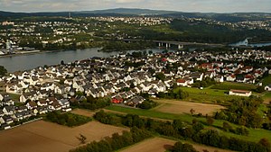
Engers
Distance: Approx. 1315 meters
Latitude and longitude: 50.42972222,7.57027778
Engers is a district of Neuwied on the right banks of the river Rhine in Germany located next to Koblenz in Rhineland-Palatinate. Engers has 5,367 inhabitants. It is highwater-endangered by its direct contact with the river Rhine.

Bendorf
Town in Rhineland-Palatinate, Germany
Distance: Approx. 1315 meters
Latitude and longitude: 50.42972222,7.57027778
Bendorf (German pronunciation: [ˈbɛndɔʁf] ) is a town in the district of Mayen-Koblenz, in Rhineland-Palatinate, Germany, on the right bank of the Rhine, approx. 7 kilometres (4 miles) north of Koblenz.

Kaltenengers
Municipality in Rhineland-Palatinate, Germany
Distance: Approx. 3102 meters
Latitude and longitude: 50.41722222,7.54361111
Kaltenengers is a municipality in the district of Mayen-Koblenz in Rhineland-Palatinate, western Germany.
Weitersburg
Municipality in Rhineland-Palatinate, Germany
Distance: Approx. 3987 meters
Latitude and longitude: 50.41118056,7.59655833
Weitersburg is a municipality in the district of Mayen-Koblenz in Rhineland-Palatinate, western Germany.
Sankt Sebastian
Municipality in Rhineland-Palatinate, Germany
Distance: Approx. 3231 meters
Latitude and longitude: 50.41222222,7.56333333
Sankt Sebastian is a municipality in the district of Mayen-Koblenz in Rhineland-Palatinate, western Germany.

Engers station
Railway station in Neuwied, Germany
Distance: Approx. 2164 meters
Latitude and longitude: 50.42611111,7.54666667
Engers station is a through station and a former railway junction in the district of Engers in the town of Neuwied in the German state of Rhineland-Palatinate. It is on the East Rhine Railway (German: Rechte Rheinstrecke, Right Rhine line) and was formerly also the beginning of a line to Au (Sieg) and had a large freight yard.
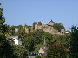
Sayn Castle
Distance: Approx. 981 meters
Latitude and longitude: 50.4389944,7.5793
The ruins of Sayn Castle (German: Burg Sayn), the 12th century family castle of the counts of Sayn and Sayn-Wittgenstein, are in Sayn, part of the borough of Bendorf on the Rhine, between Koblenz and Neuwied in the county of Mayen-Koblenz in the German state of Rhineland-Palatinate.

Sayn (river)
River in Germany
Distance: Approx. 2594 meters
Latitude and longitude: 50.418527,7.557478
The Sayn (frequently also called the Saynbach) is a small river, just under 43 kilometres (27 mi) long, in the south of the Westerwald hill region of Germany. It rises near Himburg in the Upper Westerwald and empties into the River Rhine in Bendorf (between the towns of Koblenz and Neuwied).

Brexbach
River in Germany
Distance: Approx. 616 meters
Latitude and longitude: 50.4371,7.57173889
The Brexbach (historically: Brachysa) is a river, just under 22 kilometres (14 mi) long, and an orographically left-hand tributary of the Saynbach in the German state of Rhineland-Palatinate.
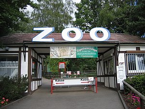
Neuwied Zoo
Distance: Approx. 1315 meters
Latitude and longitude: 50.453,7.565
The Neuwied Zoo (German: Zoo Neuwied) is a zoo located on the edge of the town of Neuwied, Rhineland-Palatinate. It borders the Rhine-Westerwald Nature Park. In 2007, the zoo had over 270,000 visitors.
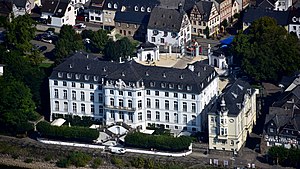
Schloss Engers
Former electoral summer palace in Engers, Germany
Distance: Approx. 2625 meters
Latitude and longitude: 50.42246,7.54342
Schloss Engers (English: Engers palace) is a Baroque-style palace in Engers, near Koblenz, Germany. It is situated on the banks of the Rhine river. Johann IX Philipp von Walderdorff (1701–1768), Prince-Elector of Trier, constructed the palace between 1759 and 1764 based on a design by the architect Johanness Seiz.
Weather in this IP's area
few clouds
19 Celsius
19 Celsius
17 Celsius
20 Celsius
1024 hPa
74 %
1024 hPa
1010 hPa
10000 meters
0.45 m/s
3.58 m/s
202 degree
13 %
07:11:52
19:35:07