Country:
 Turkey
Region:
City:
Latitude and Longitude:
Time Zone:
Postal Code:
IP information under different IP Channel
ip-api
Country
Region
City
ASN
Time Zone
ISP
Blacklist
Proxy
Latitude
Longitude
Postal
Route
IPinfo
Country
Region
City
ASN
Time Zone
ISP
Blacklist
Proxy
Latitude
Longitude
Postal
Route
MaxMind
Country
Region
City
ASN
Time Zone
ISP
Blacklist
Proxy
Latitude
Longitude
Postal
Route
Luminati
Country
 GB
GBRegion
eng
City
london
ASN
Time Zone
Europe/London
ISP
PENTECH BILISIM TEKNOLOJILERI SANAYI VE TICARET LIMITED SIRKETi
Latitude
Longitude
Postal
db-ip
Country
Region
City
ASN
Time Zone
ISP
Blacklist
Proxy
Latitude
Longitude
Postal
Route
ipdata
Country
Region
City
ASN
Time Zone
ISP
Blacklist
Proxy
Latitude
Longitude
Postal
Route
Popular places and events near this IP address
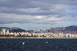
Maltepe, Istanbul
District and municipality in Istanbul, Turkey
Distance: Approx. 1063 meters
Latitude and longitude: 40.92472222,29.13111111
Maltepe is a municipality and district of Istanbul Province, Turkey. Its area is 53 km2, and its population is 528,544 (2022). It is on the northern shore of the Sea of Marmara, adjacent to the Kadıköy district to the west, Kartal district to the east and Ataşehir district to the northwest.
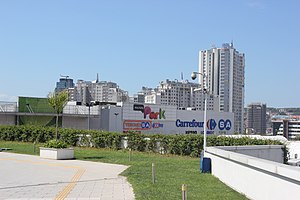
CarrefourSA Maltepe Park
Shopping mall in Istanbul, Turkey
Distance: Approx. 2109 meters
Latitude and longitude: 40.91944444,29.16361111
CarrefourSA Maltepe Park, also known as Maltepe Park, opened on February 12, 2005, is a modern shopping mall in Cevizli neighborhood of Maltepe district in Istanbul, Turkey. The shopping mall is owned by CarrefourSA, a joint venture of French retail giant Carrefour with the Turkish Sabancı Holding. The cost of the investment totaled to €80 million.

Maltepe railway station
Distance: Approx. 1152 meters
Latitude and longitude: 40.920397,29.135218
Maltepe station is located in Maltepe, Istanbul. The station is 14.3 km (8.9 mi) east from Haydarpaşa Terminal and is located directly southeast of the historical city center of Maltepe. The station has 2 platforms for passenger traffic.
Acıbadem University School of Medicine
Private, graduate school in Istanbul, Turkey
Distance: Approx. 1123 meters
Latitude and longitude: 40.92527778,29.15444444
Acıbadem University School of Medicine is one of the graduate schools of Acıbadem University. Acıbadem University is a private, non-profit institution, founded in 2007 and located in Istanbul, Turkey. The University is supported by the financial resources of the Kerem Aydınlar Foundation, set up by Mehmet Ali Aydınlar.

Maltepe (Istanbul Metro)
Station of the Istanbul Metro
Distance: Approx. 777 meters
Latitude and longitude: 40.9359,29.1392
Maltepe is an underground station on the M4 line of the Istanbul Metro in Maltepe. It is located beneath the Maltepe Interchange, on the D.100 State Highway, in the Zümrütevler neighborhood. Connection to IETT city buses and Istanbul Minibus service is available.
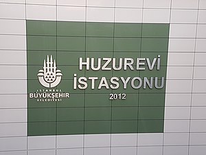
Huzurevi (Istanbul Metro)
Station of the Istanbul Metro
Distance: Approx. 333 meters
Latitude and longitude: 40.9298,29.1461
Huzurevi is an underground station on the M4 line of the Istanbul Metro in Maltepe. It is located beneath the D.100 State Highway, in the Bağlarbaşı neighborhood. Connection to IETT city buses and Istanbul Minibus service is available.

Gülsuyu (Istanbul Metro)
Station of the Istanbul Metro
Distance: Approx. 1257 meters
Latitude and longitude: 40.9236,29.1551
Gülsuyu is an underground station on the M4 line of the Istanbul Metro in Maltepe. It is located beneath the D.100 State Highway, just east of the Gülsuyu interchange, in the Cevizi neighborhood. Connection to IETT city buses and Istanbul Minibus service is available.

Esenkent (Istanbul Metro)
Station of the Istanbul Metro
Distance: Approx. 2234 meters
Latitude and longitude: 40.9207,29.1662
Esenkent is an underground station on the M4 line of the Istanbul Metro in Maltepe. It is located beneath the D.100 State Highway, just west of the Cevizli interchange, in the Esenkent neighborhood and is the easternmost metro station in Maltepe. Connection to IETT city buses and Istanbul Minibus service is available.
İdealtepe railway station
Distance: Approx. 2482 meters
Latitude and longitude: 40.9372,29.1146
İdealtepe railway station (Turkish: İdealtepe istasyonu) is a railway station in Maltepe, Istanbul. Located along Turgut Özal Boulevard and the Sea of Marmara, it was a station on the Haydarpaşa suburban commuter line from 1966 to 2013. The station platforms were rebuilt and expanded for the Marmaray commuter rail system opened on 12 March 2019.
Nassete
Ancient town of Bithynia
Distance: Approx. 1469 meters
Latitude and longitude: 40.918692,29.131811
Nassete was a coastal town of ancient Bithynia located on the road from Libyssa to Chalcedon on the north coast of the Propontis. Its site is located near Maltepe in Asiatic Turkey.
Marmara University Prof. Dr. Asaf Ataseven Hospital
Hospital in Istanbul, Turkey
Distance: Approx. 2394 meters
Latitude and longitude: 40.950624,29.138468
Marmara University Prof. Dr. Asaf Ataseven Hospital (Turkish: Marmara Üniversitesi Prof.

Maltepe Hasan Polat Stadium
Distance: Approx. 1342 meters
Latitude and longitude: 40.9205,29.1313
Maltepe Hasan Polat Stadium is a public multi-purpose stadium in Maltepe, Istanbul, Turkey. The stadium's name honours Hasan Polat, late president of the Turkish Football Federation and former player of Gençlerbirliği S.K. Since the 2022 season it is the home field of the Istanbul Rams (now known as the Koç Rams) in the European League of Football. Istanbul Maltepespor and Beyoğlu Yeni Çarşı FK also use the stadium for association football matches.
Weather in this IP's area
clear sky
25 Celsius
25 Celsius
24 Celsius
25 Celsius
1009 hPa
44 %
1009 hPa
1003 hPa
10000 meters
6.69 m/s
260 degree
07:09:24
18:31:00