80.190.159.197 - IP Lookup: Free IP Address Lookup, Postal Code Lookup, IP Location Lookup, IP ASN, Public IP
Country:
Region:
City:
Location:
Time Zone:
Postal Code:
IP information under different IP Channel
ip-api
Country
Region
City
ASN
Time Zone
ISP
Blacklist
Proxy
Latitude
Longitude
Postal
Route
Luminati
Country
Region
by
City
hebertshausen
ASN
Time Zone
Europe/Berlin
ISP
NorthC Deutschland GmbH
Latitude
Longitude
Postal
IPinfo
Country
Region
City
ASN
Time Zone
ISP
Blacklist
Proxy
Latitude
Longitude
Postal
Route
IP2Location
80.190.159.197Country
Region
niedersachsen
City
haar
Time Zone
Europe/Berlin
ISP
Language
User-Agent
Latitude
Longitude
Postal
db-ip
Country
Region
City
ASN
Time Zone
ISP
Blacklist
Proxy
Latitude
Longitude
Postal
Route
ipdata
Country
Region
City
ASN
Time Zone
ISP
Blacklist
Proxy
Latitude
Longitude
Postal
Route
Popular places and events near this IP address

Dinkelland
Municipality in Overijssel, Netherlands
Distance: Approx. 5340 meters
Latitude and longitude: 52.36666667,7
Dinkelland (Dutch pronunciation: [ˈdɪŋkəllɑnt] ) is a municipality in the eastern Netherlands. For a short time it was known as Denekamp (one of its component towns) until it was renamed in 2002.
County of Bentheim (district)
District in Lower Saxony, Germany
Distance: Approx. 6770 meters
Latitude and longitude: 52.42,7.08
County of Bentheim (German: Grafschaft Bentheim) is a district (Landkreis) in Lower Saxony, Germany. It is bounded by (from the west and clockwise) the Dutch provinces of Overijssel and Drenthe, the district of Emsland, and the districts of Steinfurt and Borken in North Rhine-Westphalia.

Nordhorn
Town in Lower Saxony, Germany
Distance: Approx. 8125 meters
Latitude and longitude: 52.43194444,7.06777778
Nordhorn (Northern Low Saxon: Nothoorn, or Notthoarn, Netthoarn and Noordhoorn) is a town in Lower Saxony, Germany. It is the district seat of Grafschaft Bentheim in Lower Saxony's southwesternmost corner, near the border with the Netherlands and the boundary with North Rhine-Westphalia.

Denekamp
Town in Overijssel, Netherlands
Distance: Approx. 5185 meters
Latitude and longitude: 52.37944444,7.00888889
Denekamp (Dutch pronunciation: [ˈdeːnəkɑmp] ) is a town in the Dutch province of Overijssel. It is a part of the region of Twente and the municipality of Dinkelland, and lies about 9 km northeast of Oldenzaal. The town was first noted as early as the 10th century when it was referred to as Daginghem, and means "settlement of the people of Dago or Dano".
Noord Deurningen
Village in Overijssel, Netherlands
Distance: Approx. 5504 meters
Latitude and longitude: 52.39694444,7.02527778
Noord Deurningen is a village in the Dutch province of Overijssel. It is a part of the municipality of Dinkelland, and lies about 11 km northeast of Oldenzaal.

Isterberg
Municipality in Lower Saxony, Germany
Distance: Approx. 4816 meters
Latitude and longitude: 52.34888889,7.14638889
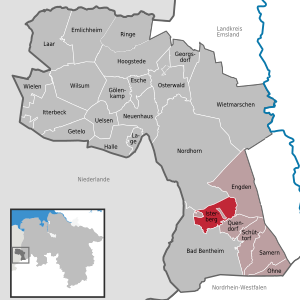
The community of Isterberg, in Lower Saxony’s district of Grafschaft Bentheim, came into being in the 1970s, through the amalgamation of the two former communities of Wengsel and Neerlage. It lies between Bad Bentheim and Nordhorn, and is part of the Samtgemeinde ("joint community") of Schüttorf (whose administrative seat is in the like-named town). There is no actual village centre.

Quendorf
Municipality in Lower Saxony, Germany
Distance: Approx. 7745 meters
Latitude and longitude: 52.33333333,7.18333333
Quendorf is a rural community belonging to the Joint Community of Schüttorf in southwestern Lower Saxony. There is no village centre. The community is made up of several settlements and scattered farms.

Beuningen, Overijssel
Village in Overijssel, Netherlands
Distance: Approx. 5352 meters
Latitude and longitude: 52.35861111,6.99888889
Beuningen (Dutch pronunciation: [ˈbøːnɪŋə(n)] ) is a village in the eastern Netherlands. It is located in the municipality of Losser, Overijssel and situated along the river Dinkel, in a mainly rural area, approximately one kilometre south of Denekamp.

Bad Bentheim station
Railway station in Bad Bentheim, Germany
Distance: Approx. 7725 meters
Latitude and longitude: 52.30972222,7.15722222
Bad Bentheim is a railway station located in Bad Bentheim, Germany. The station was opened on 18 October 1865 and is located on the Almelo - Salzbergen railway. The train services are operated by Deutsche Bahn with NS International, Bentheimer Eisenbahn and the WestfalenBahn.

De Lutte
Village in Overijssel, Netherlands
Distance: Approx. 7802 meters
Latitude and longitude: 52.31277778,6.99166667
De Lutte is a village in the Dutch province of Overijssel. It is located in the municipality of Losser. It is located close to the border between the Netherlands and Germany.

Bentheim Castle
Castle in Germany
Distance: Approx. 8277 meters
Latitude and longitude: 52.3025,7.1563
Bentheim Castle (German: Burg Bentheim) is an early medieval hill castle in Bad Bentheim, Lower Saxony, Germany. The castle is first mentioned in the 11th century under the name binithem.
Quendorf station
Railway station in Quendorf, Germany
Distance: Approx. 6813 meters
Latitude and longitude: 52.33861111,7.17194444
Quendorf is a railway station located in Quendorf, Lower Saxony, Germany. The station features a newly built halt, which opened in 2019. It serves the Regionalbahn line 56 (Bad Bentheim – Neuenhaus), with trains stopping at the station every hour.
Weather in this IP's area
overcast clouds
8 Celsius
6 Celsius
8 Celsius
9 Celsius
1034 hPa
91 %
1034 hPa
1030 hPa
10000 meters
3.14 m/s
6.2 m/s
213 degree
93 %
