80.190.158.163 - IP Lookup: Free IP Address Lookup, Postal Code Lookup, IP Location Lookup, IP ASN, Public IP
Country:
Region:
City:
Location:
Time Zone:
Postal Code:
IP information under different IP Channel
ip-api
Country
Region
City
ASN
Time Zone
ISP
Blacklist
Proxy
Latitude
Longitude
Postal
Route
Luminati
Country
Region
by
City
hebertshausen
ASN
Time Zone
Europe/Berlin
ISP
NorthC Deutschland GmbH
Latitude
Longitude
Postal
IPinfo
Country
Region
City
ASN
Time Zone
ISP
Blacklist
Proxy
Latitude
Longitude
Postal
Route
IP2Location
80.190.158.163Country
Region
bayern
City
germering
Time Zone
Europe/Berlin
ISP
Language
User-Agent
Latitude
Longitude
Postal
db-ip
Country
Region
City
ASN
Time Zone
ISP
Blacklist
Proxy
Latitude
Longitude
Postal
Route
ipdata
Country
Region
City
ASN
Time Zone
ISP
Blacklist
Proxy
Latitude
Longitude
Postal
Route
Popular places and events near this IP address
Rosenheim (district)
District in Bavaria, Germany
Distance: Approx. 4121 meters
Latitude and longitude: 47.92,12.17
Rosenheim is a Landkreis (district) in the south of Bavaria, Germany. Neighboring districts are, clockwise from the west, Miesbach, Munich, Ebersberg, Mühldorf, and Traunstein, with the Austrian province Tirol across the southern border. The district entirely surrounds the city of Rosenheim, which is independently administered but hosts the district's administration; both the city and the district share the "RO" designation for their license plates.

Rosenheim
Town in Bavaria, Germany
Distance: Approx. 6420 meters
Latitude and longitude: 47.85,12.13333333
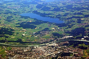
Rosenheim is a city in Bavaria, Germany. It is an independent city located in the centre of the district of Rosenheim (Upper Bavaria), and is also the seat of its administration. It is located on the west bank of the Inn at the confluence of the rivers Inn and Mangfall, in the Bavarian Alpine Foreland.

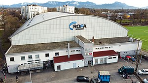
Rofa-Stadion
Arena in Rosenheim, Germany
Distance: Approx. 6356 meters
Latitude and longitude: 47.85044444,12.13208333
The ROFA-Stadion is an arena in Rosenheim, Germany. It is primarily used for ice hockey. The stadium opened in 1962 as an open-air stadium and got roofed in 1973.
Großkarolinenfeld
Municipality in Bavaria, Germany
Distance: Approx. 3390 meters
Latitude and longitude: 47.89083333,12.07972222
Großkarolinenfeld (spelled with the German ß) is a municipality in the district of Rosenheim in Bavaria in Germany. It is located at the Munich–Rosenheim railway. The Großkarolinenfeld station is served about once per hour by local trains of the company Bayerische Regiobahn.
Prutting
Municipality in Bavaria, Germany
Distance: Approx. 6136 meters
Latitude and longitude: 47.9,12.2
Prutting is a municipality in the district of Rosenheim in Bavaria in Germany.

Schechen
Municipality in Bavaria, Germany
Distance: Approx. 2522 meters
Latitude and longitude: 47.928987,12.125225
Schechen (Central Bavarian: Schecha) is a municipality in the district of Rosenheim in Bavaria in Germany. It lies on the river Inn.

Rosenheim poltergeist claim
Distance: Approx. 5919 meters
Latitude and longitude: 47.85417222,12.12975278
The Rosenheim poltergeist claim is the name given to claims of a poltergeist in Rosenheim in southern Bavaria in the late 1960s by German parapsychologist Hans Bender. Bender alleged that electrical and physical disturbances in the office of the lawyer Sigmund Adam were caused by the telekinetic powers of 19-year-old secretary Annemarie Schaberl. Bender's investigation has been criticized for omitting key details and avoiding naturalistic explanations.

Rosenheim station
Railway station in Bavaria, Germany
Distance: Approx. 6283 meters
Latitude and longitude: 47.85036111,12.11952778
Rosenheim station (German: Bahnhof Rosenheim) is the main railway station in the city of Rosenheim in Bavaria, Germany. It is the seventh largest passenger station in Bavaria and an important railway hub between the Munich–Rosenheim railway line and the lines to Salzburg, Kufstein/Innsbruck and Mühldorf, as well as the Mangfall Valley Railway.
Rosenheim University of Applied Sciences
Distance: Approx. 4495 meters
Latitude and longitude: 47.86710833,12.10735278
Rosenheim Technical University of Applied Sciences or TH Rosenheim (from German Technische Hochschule Rosenheim) is a university in Rosenheim, Germany with its main campus in Rosenheim and campuses in Mühldorf am Inn, Burghausen and Chiemgau. The TH Rosenheim is an hour's drive away from the Bavarian capital Munich and the Austrian city of Salzburg. The university's key areas of expertise are business, technology, design, healthcare and social studies.
Verband Bayerischer Amateurtheater
Distance: Approx. 5820 meters
Latitude and longitude: 47.855,12.129
Verband Bayerischer Amateurtheater is a theatre company based in Rosenheim, Bavaria, Germany.

Erlbach (Rott)
River in Germany
Distance: Approx. 3515 meters
Latitude and longitude: 47.8915,12.0772
Erlbach is a river of Bavaria, Germany. The Erlbach springs south of Großkarolinenfeld. and discharges near the center of Großkarolinenfeld from the right into the Rott.

Großkarolinenfeld station
Railway station in Großkarolinenfeld, Germany
Distance: Approx. 3191 meters
Latitude and longitude: 47.8889,12.085
Großkarolinenfeld station is a railway station in the municipality of Großkarolinenfeld, located in the Rosenheim district of Bavaria, Germany. It has two tracks, which are located next to two side platforms, which are connected by an underpass.
Weather in this IP's area
scattered clouds
3 Celsius
3 Celsius
2 Celsius
3 Celsius
1037 hPa
78 %
1037 hPa
963 hPa
10000 meters
1.15 m/s
2.05 m/s
64 degree
37 %

