80.190.142.6 - IP Lookup: Free IP Address Lookup, Postal Code Lookup, IP Location Lookup, IP ASN, Public IP
Country:
 Germany
Region:
City:
Location:
Time Zone:
Postal Code:
ISP:
ASN:
language:
User-Agent:
Proxy IP:
Blacklist:
IP information under different IP Channel
ip-api
Country
Region
City
ASN
Time Zone
ISP
Blacklist
Proxy
Latitude
Longitude
Postal
Route
db-ip
Country
Region
City
ASN
Time Zone
ISP
Blacklist
Proxy
Latitude
Longitude
Postal
Route
IPinfo
Country
Region
City
ASN
Time Zone
ISP
Blacklist
Proxy
Latitude
Longitude
Postal
Route
IP2Location
80.190.142.6Country
deRegion
bayern
City
riemerling
Time Zone
Europe/Berlin
ISP
Language
User-Agent
Latitude
Longitude
Postal
ipdata
Country
Region
City
ASN
Time Zone
ISP
Blacklist
Proxy
Latitude
Longitude
Postal
Route
Popular places and events near this IP address

Neubiberg
Municipality in Bavaria, Germany
Distance: Approx. 2576 meters
Latitude and longitude: 48.08333333,11.68333333
Neubiberg is a municipality and a village in south-east of Munich, Germany, founded in 1912. Today, the largest part of the area is used by Bundeswehr University Munich. Neubiberg consists mainly of semi-detached and detached houses and has many gardens.

Ottobrunn
Municipality in Bavaria, Germany
Distance: Approx. 1374 meters
Latitude and longitude: 48.06666667,11.66666667
Ottobrunn (German: [ɔtoˈbʁʊn] ) is a municipality southeast of Munich, Bavaria, Germany, founded in 1955. Ottobrunn consists of mainly semi-detached and detached houses, as well as extensive garden areas. Ottobrunn is also the German Headquarters of Airbus Defense and Space (former European Aeronautic Defence and Space Company (EADS)), with the majority of Airbus DS grounds situated in the neighbouring community of Taufkirchen.

Lauterbach (company)
Distance: Approx. 4828 meters
Latitude and longitude: 48.022921,11.715559
Lauterbach GmbH (German pronunciation: [ˈlaʊtɐbax] ) is a German firm specializing in Debuggers, Trace Modules and logic analyzers used for debugging, profiling and analyzing embedded systems. The company was founded in 1979 by Lothar Lauterbach. In 2009 the firm was renamed from Lauterbach Datentechnik GmbH to Lauterbach GmbH. The company is global market leader for pure software as well as hardware-assisted debug- and trace development tools for embedded systems, which it sells under the brand name TRACE32.
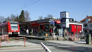
Ottobrunn station
Railway station in Germany
Distance: Approx. 416 meters
Latitude and longitude: 48.06302778,11.67875
Ottobrunn is a station of the Munich S-Bahn. It is located in the south-eastern suburb of Ottobrunn. It is served by the line S5 in the direction of Kreuzstraße and Weßling in 20 minute intervals.

Therese-Giehse-Allee station
Metro station in Munich, Germany
Distance: Approx. 4843 meters
Latitude and longitude: 48.09472222,11.64277778
Therese-Giehse-Allee is a station on the U5 line of the Munich U-Bahn, named after the German actress Therese Giehse. The station serves a residential area and lies at the center of Neuperlach Zentrum and Neuperlach Süd stations, the final stop of the U5. It is integrated with the MVV (Munich Transport and Tariff Association).

Munich-Neuperlach Süd station
Station of the Munich S-Bahn and U-Bahn
Distance: Approx. 4222 meters
Latitude and longitude: 48.08888889,11.64527778
Munich-Neuperlach Süd (south) is a railway station in Munich, the state capital of Bavaria, Germany. It is located in the Neuperlach area of the borough of Ramersdorf-Perlach. It serves as an transportation hub for the borough, providing interchange between S-Bahn, U-Bahn, and local bus services.

Brunnthal
Municipality in Bavaria, Germany
Distance: Approx. 4847 meters
Latitude and longitude: 48.01666667,11.68333333
Brunnthal is a municipality in the district of Munich in Bavaria in Germany.

Hohenbrunn
Municipality in Bavaria, Germany
Distance: Approx. 1733 meters
Latitude and longitude: 48.05,11.7
Hohenbrunn is a municipality in the district of Munich in Bavaria, Germany. It is located in the southeast of Munich, occupying an area of 16.82 km². It connects to the Bundesautobahn 99 with its own exit, BAS Hohenbrunn.

Putzbrunn
Town in Bavaria, Germany
Distance: Approx. 2649 meters
Latitude and longitude: 48.06666667,11.71666667
Putzbrunn is a town in the district of Munich, Bavaria in Germany.

Bundeswehr University Munich
German university
Distance: Approx. 3984 meters
Latitude and longitude: 48.08027778,11.63805556
University of the Bundeswehr Munich (German: Universität der Bundeswehr München, UniBw München) is one of two research universities in Germany at federal level that both were founded in 1973 as part of the German Armed Forces (Bundeswehr). Originally called Hochschule der Bundeswehr München the institution was supposed to offer civilian academic education for military officers. As an uncommon feature amongst German universities University of the Bundeswehr Munich unifies a more theoretical research university division and a more practical-oriented College of Applied Sciences branch.
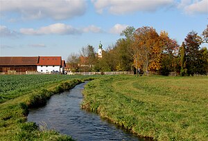
Hachinger Bach
River in Germany
Distance: Approx. 4467 meters
Latitude and longitude: 48.08333333,11.63333333
The Hachinger Bach is a river in Bavaria, Germany. It flows southwards of Munich, through the townships of Oberhaching, Taufkirchen, Unterhaching and Unterbiberg, and enters the Munich city area in Perlach. It is twelve kilometers long.
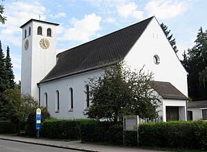
Maria Rosenkranzkönigin
Church in Neubiberg, Germany
Distance: Approx. 1995 meters
Latitude and longitude: 48.0751,11.6675
Maria Rosenkranzkönigin (English: "Our Lady of the Rosary" is a Roman Catholic parish church in the municipality of Neubiberg, near (Munich) in Bavaria. The church was built in 1928 using functional-modern forms of architecture. It was consecrated on November 11, 1928 by Michael Cardinal von Faulhaber.
Weather in this IP's area
overcast clouds
1 Celsius
-1 Celsius
-2 Celsius
1 Celsius
1031 hPa
84 %
1031 hPa
960 hPa
10000 meters
1.34 m/s
1.34 m/s
72 degree
100 %