80.190.136.148 - IP Lookup: Free IP Address Lookup, Postal Code Lookup, IP Location Lookup, IP ASN, Public IP
Country:
 Germany
Region:
City:
Location:
Time Zone:
Postal Code:
ISP:
ASN:
language:
User-Agent:
Proxy IP:
Blacklist:
IP information under different IP Channel
ip-api
Country
Region
City
ASN
Time Zone
ISP
Blacklist
Proxy
Latitude
Longitude
Postal
Route
db-ip
Country
Region
City
ASN
Time Zone
ISP
Blacklist
Proxy
Latitude
Longitude
Postal
Route
IPinfo
Country
Region
City
ASN
Time Zone
ISP
Blacklist
Proxy
Latitude
Longitude
Postal
Route
IP2Location
80.190.136.148Country
deRegion
bayern
City
teising
Time Zone
Europe/Berlin
ISP
Language
User-Agent
Latitude
Longitude
Postal
ipdata
Country
Region
City
ASN
Time Zone
ISP
Blacklist
Proxy
Latitude
Longitude
Postal
Route
Popular places and events near this IP address

Polling, Mühldorf
Municipality in Bavaria, Germany
Distance: Approx. 4147 meters
Latitude and longitude: 48.21666667,12.56666667
Polling is a municipality in the district of Mühldorf in Bavaria in Germany. It lies on the river Inn.

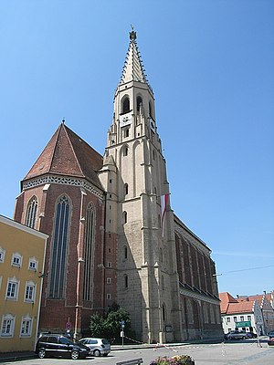
Altötting
Town in Bavaria, Germany
Distance: Approx. 4630 meters
Latitude and longitude: 48.22666667,12.67833333
Altötting (German: [altˈʔœtɪŋ] , Bavarian: [ɔidˈɛːde̝ŋ]; Oidäding) is a town in Bavaria, capital of the district Altötting of Germany. For 500 years it has been the scene of religious pilgrimages by Catholics in honor of Mary, including a visit by Pope John Paul II in 1980 and one by Pope Benedict XVI in 2006.
Töging am Inn
Town in Bavaria, Germany
Distance: Approx. 4149 meters
Latitude and longitude: 48.25,12.56666667
Töging am Inn (Central Bavarian: Deging am Inn) is a town of 9,382 inhabitants in the district of Altötting, Upper Bavaria, Germany. It lies on the river Inn.
Neuötting
Town in Bavaria, Germany
Distance: Approx. 5277 meters
Latitude and longitude: 48.21666667,12.68333333
Neuötting is a town in the district of Altötting, in Bavaria, Germany. It is situated on the river Inn, 2 km north of Altötting, about 70 km north of Salzburg, 80 southwest of Passau and almost 100 km east of Munich. It is a stop on the railway line between Munich and Simbach.

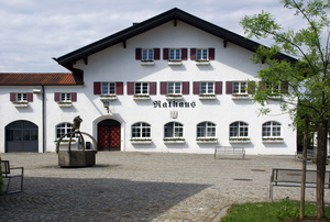
Teising
Municipality in Bavaria, Germany
Distance: Approx. 4 meters
Latitude and longitude: 48.23333333,12.61666667
Teising is a municipality in the district of Altötting in Bavaria in Germany and belongs to the parish Burgkirchen am Wald. The village is located very centrally between the towns of Altötting and Mühldorf am Inn. Since 2008 most traffic is rerouted to the nearby freeway A94, which help the village center gain considerably in attractiveness.

Tüßling
Municipality in Bavaria, Germany
Distance: Approx. 3091 meters
Latitude and longitude: 48.21666667,12.58333333
Tüßling is a market town in the district of Altötting in Bavaria in Germany.

Winhöring
Municipality in Bavaria, Germany
Distance: Approx. 4460 meters
Latitude and longitude: 48.26666667,12.65
Winhöring (Central Bavarian: Winaring) is a municipality in the district of Altötting in Bavaria in Germany. The river Inn forms the municipality's southern border. The smaller river Isen flows through the municipality and then into the Inn.

Erharting
Municipality in Bavaria, Germany
Distance: Approx. 6094 meters
Latitude and longitude: 48.28333333,12.58333333
Erharting is a municipality in the district of Mühldorf in Bavaria in Germany.

Isen (river)
River in Germany
Distance: Approx. 4543 meters
Latitude and longitude: 48.2506,12.6722
The Isen is a small river in southeast Upper Bavaria with a length of about 81 kilometres. The Isen rises near Lacken (in the municipality of Maitenbeth, district of Mühldorf am Inn) and flows through one of the most unspoiled regions of Old Bavaria (Altbayern): the Isen Valley. First seeing the light of day in the district of Mühldorf, the waters of the Isen flow initially into the district of Erding along the villages of Isen, Lengdorf and Dorfen, and then return again to Mühldorf district coursing through (Schwindegg, Ampfing, Mettenheim, Mühldorf am Inn and Erharting).

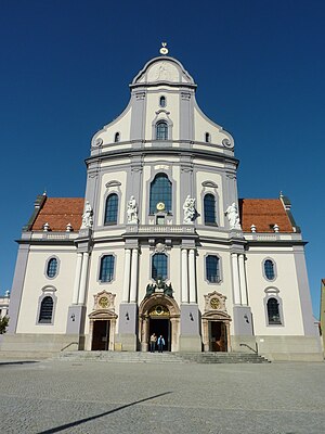
Shrine of Our Lady of Altötting
Distance: Approx. 4506 meters
Latitude and longitude: 48.22626,12.67654
The Shrine of Our Lady of Altötting, also known as the Chapel of Grace (German: Gnadenkapelle), is the national shrine of Bavaria dedicated to the Blessed Virgin Mary. It is known for the many healings which are said to have taken place there, and is commonly called the Lourdes of Germany. The octagonal chapel which houses the image of Our Lady dates to about A.D. 660, and is the oldest Marian shrine in Germany.
Basilica of St. Ann, Altötting
Church in Bavaria, Germany
Distance: Approx. 4269 meters
Latitude and longitude: 48.2279,12.6737
The Basilica of St. Ann (German: Basilika St. Anna ) also called Altötting Basilica It is the main place of Catholic worship of Altötting, Bavaria, in the diocese of Passau.
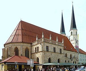
Collegiate Church of Saints Philip and James, Altötting
Distance: Approx. 4489 meters
Latitude and longitude: 48.22555556,12.67611111
The Collegiate Church of Saints Philip and James, Altötting (German: Stiftspfarrkirche St. Philipp und Jakob), with the associated college or community of secular canons (German: Kollegiatstift Altötting), was founded in about 1228 in Altötting, Bavaria, southern Germany.
Weather in this IP's area
overcast clouds
-1 Celsius
-5 Celsius
-1 Celsius
-0 Celsius
1024 hPa
99 %
1024 hPa
969 hPa
10000 meters
2.66 m/s
6.12 m/s
74 degree
100 %