80.184.122.146 - IP Lookup: Free IP Address Lookup, Postal Code Lookup, IP Location Lookup, IP ASN, Public IP
Country:
Region:
City:
Location:
Time Zone:
Postal Code:
IP information under different IP Channel
ip-api
Country
Region
City
ASN
Time Zone
ISP
Blacklist
Proxy
Latitude
Longitude
Postal
Route
Luminati
Country
Region
ku
City
kuwaitcity
ASN
Time Zone
Asia/Kuwait
ISP
Zajil International Telecom Company KSCC
Latitude
Longitude
Postal
IPinfo
Country
Region
City
ASN
Time Zone
ISP
Blacklist
Proxy
Latitude
Longitude
Postal
Route
IP2Location
80.184.122.146Country
Region
al farwaniyah
City
ar rabiyah
Time Zone
Asia/Kuwait
ISP
Language
User-Agent
Latitude
Longitude
Postal
db-ip
Country
Region
City
ASN
Time Zone
ISP
Blacklist
Proxy
Latitude
Longitude
Postal
Route
ipdata
Country
Region
City
ASN
Time Zone
ISP
Blacklist
Proxy
Latitude
Longitude
Postal
Route
Popular places and events near this IP address

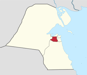
Farwaniya Governorate
Governorate of Kuwait
Distance: Approx. 3230 meters
Latitude and longitude: 29.277,47.959
Farwaniya Governorate (Arabic: محافظة الفروانية Muḥāfaẓat al-Farwānīyah) is the most populous of the six governorates of Kuwait, and is the country's only landlocked governorate. It is Kuwait City's main residential area and also forms an important part of Kuwait's commercial activities.

Jaber Al-Ahmad International Stadium
Multi-purpose stadium in Ardiya, Kuwait City, Kuwait
Distance: Approx. 2983 meters
Latitude and longitude: 29.27142778,47.91861111
Jaber al-Ahmad International Stadium (Arabic: ملعب جابر الأحمد الدولي) is a multi-purpose stadium in the Ardhiyah area of Kuwait City, Kuwait. Completed in 2009, it is used mostly for football matches and athletics. The stadium has a capacity of 60,000 seated spectators, the building is constructed in 4 levels, with 54 corporate boxes and a parking lot with a 6,001-car capacity.

Arab Open University
Non-profit university in the Arab world
Distance: Approx. 2411 meters
Latitude and longitude: 29.28238889,47.91288889
Arab Open University (AOU) (Arabic: الجامعة العربية المفتوحة) is a non-profit university system in the Arab world. Headquartered in Kuwait, the system is composed of 16 campuses across 9 countries: Ardiya in Kuwait, Riyadh, Jeddah, Dammam, Madinah, Ḥail, Al-Ahsa in Saudi Arabia, Seeb in Oman, A'ali in Bahrain, Amman in Jordan, Al-Bireh in Palestine, Beirut, Antelias, Tripoli in Lebanon, El-Shorouk in Egypt and Khartoum in Sudan. The university has a combined student body of 62,612 students, 61,886 of which are postgraduates while 742 of which are postgraduates, 1031 staff members and 77,037 living alumni.
Jleeb Al-Shuyoukh
Area in Farwaniya Governorate, Kuwait
Distance: Approx. 3165 meters
Latitude and longitude: 29.26666667,47.93333333
Jleeb Al-Shuyoukh or Jileeb Al-Shiyukh (Gulf Arabic: جليب الشيوخ, pronounced /d͡ʒɪliːb lɪʃjuːχ/), often shortened to just Jilīb/Jileeb (الجليب), is one of the oldest and most congested areas in Kuwait. It is located within Farwaniya Governorate and borders Kuwait International Airport. It is largely inhabited by expatriates from countries such as India, Pakistan, Bangladesh, Sri Lanka, Egypt and Syria.
Farwaniya Stadium
Distance: Approx. 2965 meters
Latitude and longitude: 29.288757,47.962661
Farwaniya Stadium is a multi-use stadium in Al-Farwaniyah, Kuwait. It is generally used for football matches and is the home stadium of Al Tadamun SC, a professional football club. The stadium holds 14,000 people.
Abraq Khaytan
Place in Farwaniya, Kuwait
Distance: Approx. 3496 meters
Latitude and longitude: 29.2925,47.96888889
Abraq Khaytan or Abrag Khitan (Arabic: أبرق خيطان) is a village in Kuwait. It is located 3 miles from Kuwait International Airport. Nearby towns and villages include Al `Umariyah (0.8 nm), Al `Udayliyah (0.5 nm), Qurtubah (1.5 nm), As Surrah (1.5 nm), Al Farwaniyah (1.0 nm) and Janub Khaytan (1.3 nm).
The Avenues (Kuwait)
Largest shopping mall in Kuwait
Distance: Approx. 931 meters
Latitude and longitude: 29.3032,47.9354
The Avenues Mall is the second largest shopping mall in the Persian Gulf region. The mall is located in the Rai area extending from Fifth Ring Road from the south and Al Ghazali Highway from the east. It opened in April 2007, under the patronage of the Emir of Kuwait Sheikh Sabah Al Ahmed Al Sabah.
Farwaniya, Kuwait
Area in Farwaniya Governorate, Kuwait
Distance: Approx. 3230 meters
Latitude and longitude: 29.277,47.959
Farwaniya (Arabic: الفروانية, Gulf Arabic: /ɪlfərwaːniːjə/) is an area of Farwaniya Governorate, located within the agglomeration of Kuwait City, Kuwait. The Ghazali Expressway passes to the west of the district and the road leading to Kuwait International Airport to the east, both roads in a north–south direction. Farwaniya contains mosques, hospitals, a university, a park and other facilities.
Khaitan
City in Farwaniya Governorate, Kuwait
Distance: Approx. 3314 meters
Latitude and longitude: 29.3,47.96666667
Khaitan (Arabic: خيطان) is an area of Farwaniya Governorate, Kuwait near Kuwait City. It is the home of Khaitan Sporting Club.

Ali Sabah Al-Salem Stadium
Distance: Approx. 2708 meters
Latitude and longitude: 29.27194444,47.92444444
Ali Al-Salem Al-Sabah Stadium is a multi-use stadium in Al Farwaniyah, Kuwait. It is currently used mostly for football matches, on club level by Al-Nasr SC of the Kuwaiti Premier League. The stadium has a capacity of 11,000 spectators.
Kuwait Zoo
Zoo in Omariya, Kuwait
Distance: Approx. 2914 meters
Latitude and longitude: 29.300167,47.96245
Kuwait Zoo is a zoo located in Omariya in Kuwait. It is currently closed.
Riggae
Area in Farwaniya, Kuwait
Distance: Approx. 1801 meters
Latitude and longitude: 29.30277778,47.91666667
Al-Riggae (Arabic: الرقعي) is an area of the Farwaniya Governorate, Kuwait, located in the southwest of the centre of Kuwait City. The Al-Riggae area is distinguished by its location between the Fourth and Fifth Ring Road (its four borders between Andalus, Al-Rai, Ardiya and Shuwaikh). It includes the Courts Complex, the Public Authority for Youth and Sports, and The Avenues Mall, one of the largest malls in Kuwait.
Weather in this IP's area
clear sky
14 Celsius
14 Celsius
14 Celsius
15 Celsius
1024 hPa
77 %
1024 hPa
1020 hPa
10000 meters
1.52 m/s
1.52 m/s
2 degree