Country:
 Great Britain
Region:
City:
Latitude and Longitude:
Time Zone:
Postal Code:
IP information under different IP Channel
ip-api
Country
Region
City
ASN
Time Zone
ISP
Blacklist
Proxy
Latitude
Longitude
Postal
Route
IPinfo
Country
Region
City
ASN
Time Zone
ISP
Blacklist
Proxy
Latitude
Longitude
Postal
Route
MaxMind
Country
Region
City
ASN
Time Zone
ISP
Blacklist
Proxy
Latitude
Longitude
Postal
Route
Luminati
Country
GBRegion
eng
City
towerhamlets
ASN
Time Zone
Europe/London
ISP
BOX-CORP
Latitude
Longitude
Postal
db-ip
Country
Region
City
ASN
Time Zone
ISP
Blacklist
Proxy
Latitude
Longitude
Postal
Route
ipdata
Country
Region
City
ASN
Time Zone
ISP
Blacklist
Proxy
Latitude
Longitude
Postal
Route
Popular places and events near this IP address

Bunhill Fields
Former burial ground in London
Distance: Approx. 179 meters
Latitude and longitude: 51.52361111,-0.08888889
Bunhill Fields is a former burial ground in central London, in the London Borough of Islington, just north of the City of London. What remains is about 1.6 hectares (4.0 acres) in extent and the bulk of the site is a public garden maintained by the City of London Corporation. It was first in devoted use as a burial ground from 1665 until 1854, in which period approximately 123,000 interments were estimated to have taken place.

Old Street station
London Underground and railway station
Distance: Approx. 97 meters
Latitude and longitude: 51.52581,-0.08709
Old Street is an interchange station at the junction of Old Street and City Road in Central London for London Underground and National Rail services. The station is on the Bank branch of the Northern line between Angel and Moorgate stations and on the Northern City Line between Moorgate and Essex Road stations. The station is in the London Borough of Islington (straddling the Hackney border).

Whitefield's Tabernacle, Moorfields
Church in London, England
Distance: Approx. 138 meters
Latitude and longitude: 51.52388889,-0.0875
Whitefield's Tabernacle, Moorfields (also known as Moorfields Tabernacle) is a former church at the corner of Tabernacle Street and Leonard Street, Moorfields, London, England. The first church on the site was a wooden building erected by followers of the evangelical preacher George Whitefield in 1741. This was replaced by a brick building in 1753.

Wesley's Chapel
Methodist church in London
Distance: Approx. 179 meters
Latitude and longitude: 51.52361111,-0.08694444
Wesley's Chapel (originally the City Road Chapel) is a Methodist church situated in the St Luke's area in the south of the London Borough of Islington. Opened in 1778, it was built under the direction of John Wesley, the founder of the Methodist movement. The site is a place of worship and visitor attraction, incorporating the Museum of Methodism in its crypt and John Wesley's House next to the chapel.

Bunhill Row
Street in St Luke's, London Borough of Islington
Distance: Approx. 208 meters
Latitude and longitude: 51.52387778,-0.09018611
Bunhill Row is a street located in St Luke's, London Borough of Islington, London. The street runs north–south from Old Street to Chiswell Street. On the east side are the cemetery of Bunhill Fields and the open space of the Honourable Artillery Company's Artillery Ground.

St Luke's Hospital for Lunatics
Hospital in London, England
Distance: Approx. 135 meters
Latitude and longitude: 51.52555556,-0.08972222
St Luke's Hospital for Lunatics was founded in London in 1751 for the treatment of incurable pauper lunatics by a group of philanthropic apothecaries and others. It was the second public institution in London created to look after mentally ill people, after the Hospital of St. Mary of Bethlem (Bedlam), founded in 1246.

Old Street Roundabout
London interchange system
Distance: Approx. 73 meters
Latitude and longitude: 51.5257,-0.0875
Old Street Roundabout is a road junction in Central London, England. Historically a square roundabout, it is now a three-way junction. It is among access points of the Inner Ring Road for the adjoining St Luke's south part of Islington and the City of London beyond, west and south, respectively.

East London Tech City
Human settlement in England
Distance: Approx. 73 meters
Latitude and longitude: 51.5257,-0.0875
East London Tech City (also known as Tech City and Silicon Roundabout) is a technology cluster of high-tech companies located in East London, United Kingdom. Its main area lies broadly between St Luke's and Hackney Road, with an accelerator space for spinout companies at the Queen Elizabeth Olympic Park. A cluster of web businesses initially developed around the Old Street Roundabout in 2008.

Pulp Fiction (Banksy)
Work by stencil graffiti artist Banksy
Distance: Approx. 145 meters
Latitude and longitude: 51.526,-0.0864
Pulp Fiction is a type of work by stencil graffiti artist Banksy. Instances of it depict the characters played by Samuel L. Jackson and John Travolta in the 1994 film Pulp Fiction, with their guns replaced by bananas. A stencil graffiti work existed on a wall near the Old Street tube station in the City of London from 2002 to 2007.

XOYO
Nightclub in London
Distance: Approx. 156 meters
Latitude and longitude: 51.525445,-0.085732
XOYO is a nightclub in London. It is located on Cowper Street near Old Street station in Islington.
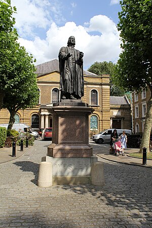
Statue of John Wesley, Shoreditch
Statue in London, United Kingdom
Distance: Approx. 163 meters
Latitude and longitude: 51.52372,-0.08713
A statue of John Wesley, an Anglican minister and theologian, by British sculptor John Adams-Acton is installed outside Wesley's Chapel, along City Road, in Shoreditch, London, United Kingdom. The statue, created in 1891, is Grade II-listed. The 10 foot high granite pedestal on which the statue is located was the work of the Methodist architect Elijah Hoole.

Pearce & Plenty
London restaurants
Distance: Approx. 217 meters
Latitude and longitude: 51.52704444,-0.08810556
Pearce & Plenty was a chain of working class restaurants in London, formed in the late 19th century. Its motto was "Quality, Economy, Despatch". The company was started by John Pearce as a coffee stall on the corner of East Road and City Road, which he operated from 1866 to 1879.
Weather in this IP's area
few clouds
16 Celsius
16 Celsius
15 Celsius
17 Celsius
1013 hPa
69 %
1013 hPa
1010 hPa
10000 meters
3.6 m/s
260 degree
20 %
07:31:31
17:58:40