Country:
 Austria
Region:
City:
Latitude and Longitude:
Time Zone:
Postal Code:
IP information under different IP Channel
ip-api
Country
Region
City
ASN
Time Zone
ISP
Blacklist
Proxy
Latitude
Longitude
Postal
Route
IPinfo
Country
Region
City
ASN
Time Zone
ISP
Blacklist
Proxy
Latitude
Longitude
Postal
Route
MaxMind
Country
Region
City
ASN
Time Zone
ISP
Blacklist
Proxy
Latitude
Longitude
Postal
Route
Luminati
Country
ATRegion
7
City
innsbruck
ASN
Time Zone
Europe/Vienna
ISP
Telekom Austria
Latitude
Longitude
Postal
db-ip
Country
Region
City
ASN
Time Zone
ISP
Blacklist
Proxy
Latitude
Longitude
Postal
Route
ipdata
Country
Region
City
ASN
Time Zone
ISP
Blacklist
Proxy
Latitude
Longitude
Postal
Route
Popular places and events near this IP address
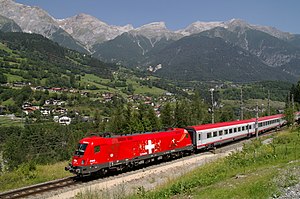
Arlberg railway
Railway line in Austria
Distance: Approx. 64 meters
Latitude and longitude: 47.2633,11.401
The Arlberg Railway (German: Arlbergbahn), which connects the Austrian cities Innsbruck and Bludenz, is Austria's only east-west mountain railway. It is one of the highest standard gauge railways in Europe and the second highest in Austria, after the Brenner. The 136.7 km line is a highly problematic mountain railway, in part because it is threatened by avalanches, mudslides, rockfalls and floods.

Akademisches Gymnasium Innsbruck
Austrian grammar school
Distance: Approx. 565 meters
Latitude and longitude: 47.2679,11.3974
The Akademisches Gymnasium Innsbruck is a public gymnasium grammar school in Innsbruck, Tyrol, Austria. Founded in 1562 by the Jesuits in the course of the Counter-Reformation, it is the oldest school in Western Austria and one of the oldest schools in the German-speaking world.

Innsbruck Hauptbahnhof
Railway station in Tyrol, Austria
Distance: Approx. 64 meters
Latitude and longitude: 47.2639,11.4008
Innsbruck Hauptbahnhof (German, 'Innsbruck Main Station' or 'Innsbruck Central Station') is the main railway station in Innsbruck, the capital city of the Austrian federal state of Tyrol. Opened in 1853, the station is a major hub for western and central Austria. In 2019, it was the 8th-busiest station in the country, and the 2nd-busiest outside of Vienna after only Linz Hauptbahnhof, with 315 train movements and 38,500 passengers daily.
MCI Management Center Innsbruck
University-level business school located in Innsbruck, Austria
Distance: Approx. 657 meters
Latitude and longitude: 47.2689,11.3975
MCI Management Center Innsbruck, located in Innsbruck, Austria, is a private business school that provides a range of study programs culminating in Bachelor’s and Master’s degrees. Additionally, it offers Executive Master’s programs such as MBA, MSc, and LL.M., alongside Executive Certificate programs, management seminars, tailored programs, and research opportunities.

Tyrol S-Bahn
Distance: Approx. 64 meters
Latitude and longitude: 47.2633,11.401
The Tyrol S-Bahn, operated by ÖBB, provides regional rail services in metropolitan Innsbruck, Austria and its hinterlands in the state of Tyrol; and extended rail services into Italy and Germany.

Lower Inn Valley Railway
Railway line in Austria
Distance: Approx. 64 meters
Latitude and longitude: 47.2633,11.401
The Lower Inn Valley Railway (German: Unterinntalbahn) is a two-track, electrified railway line that is one of the major lines of the Austrian railways. It was originally opened as the k.k. Nordtiroler Staatsbahn (Imperial and Royal North Tyrolean State Railway).

Tyrolean State Museum
Distance: Approx. 498 meters
Latitude and longitude: 47.2673275,11.3977336
The Tyrolean State Museum (German: Tiroler Landesmuseum), also known as the Ferdinandeum after Archduke Ferdinand, is located in Innsbruck, Austria. It was founded in 1823 by the Tyrolean State Museum Ferdinandeum Society (Verein Tiroler Landesmuseum Ferdinandeum). Since 2007 it has been a major division of the Tyrolean State Museums Operating Company (Tiroler Landesmuseen-Betriebsgesellschaft), which has taken over the running of the business.
Innsbruck Town Hall
City hall of Innsbruck, Austria
Distance: Approx. 618 meters
Latitude and longitude: 47.26555556,11.39388889
Innsbruck Town Hall is the building of the local government of the city of Innsbruck, Austria. The first building to house the local government was built in 1358, and was the first town hall in Tyrol, now known as Altes Rathaus. In 1897 the city administration moved to a new building, a former hotel donated to the city by the wholesaler Leonhard Lang.
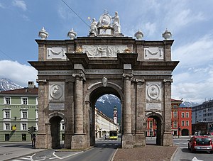
Triumphal Arch, Innsbruck
Distance: Approx. 536 meters
Latitude and longitude: 47.2625,11.39472222
The Triumphal Arch (German: Triumphpforte) is one of the best known sights in the Austrian city of Innsbruck. It is located at the southern end of the present Maria-Theresien-Straße, once the southern road out of the city.

St. Anne's Column
Distance: Approx. 598 meters
Latitude and longitude: 47.26555556,11.39416667
St. Anne's Column (German: Annasäule) stands in the city centre of Innsbruck on Maria-Theresien-Straße. It was given its name when, in 1703, the last Bavarian troops were driven from the Tyrol on St.

Kaufhaus Tyrol
Department store in Innsbruck, Austria
Distance: Approx. 548 meters
Latitude and longitude: 47.26527778,11.39472222
Kaufhaus Tyrol (German: [ˈkaʊfhaʊs tiːˈroːl]) is the current name of a department store with a long history in the centre of Innsbruck, the state capital of Tyrol, Austria. It was built in 1908, and a new building was opened in 2010. With 55 shops, it is the largest department store in Innsbruck.

Pogrom Monument
Distance: Approx. 425 meters
Latitude and longitude: 47.26337,11.396
The Pogrom Monument (German: Pogromdenkmal) is located on Eduard-Wallnöfer-Platz, in the centre of Innsbruck, and commemorates the November pogroms of 1938, during which the Innsbruck citizens Josef Adler, Wilhelm Bauer, Richard Berger and Richard Graubart were murdered. The memorial was erected in 1997.
Weather in this IP's area
broken clouds
9 Celsius
8 Celsius
7 Celsius
9 Celsius
1024 hPa
93 %
1024 hPa
955 hPa
10000 meters
1.54 m/s
75 %
06:53:34
19:24:57