80.120.58.11 - IP Lookup: Free IP Address Lookup, Postal Code Lookup, IP Location Lookup, IP ASN, Public IP
Country:
Region:
City:
Location:
Time Zone:
Postal Code:
ISP:
ASN:
language:
User-Agent:
Proxy IP:
Blacklist:
IP information under different IP Channel
ip-api
Country
Region
City
ASN
Time Zone
ISP
Blacklist
Proxy
Latitude
Longitude
Postal
Route
db-ip
Country
Region
City
ASN
Time Zone
ISP
Blacklist
Proxy
Latitude
Longitude
Postal
Route
IPinfo
Country
Region
City
ASN
Time Zone
ISP
Blacklist
Proxy
Latitude
Longitude
Postal
Route
IP2Location
80.120.58.11Country
Region
oberosterreich
City
mondsee
Time Zone
Europe/Vienna
ISP
Language
User-Agent
Latitude
Longitude
Postal
ipdata
Country
Region
City
ASN
Time Zone
ISP
Blacklist
Proxy
Latitude
Longitude
Postal
Route
Popular places and events near this IP address

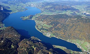
Mondsee (lake)
Lake in Austria
Distance: Approx. 5119 meters
Latitude and longitude: 47.81666667,13.38333333
Mondsee (Moon Lake) is a lake in the Upper Austrian part of the Salzkammergut and near the larger Attersee. Its southwestern shore marks the border between the states of Upper Austria and Salzburg and also between the Northern Limestone Alps in the south and the Sandstone zone of the northern Alps. The Drachenwand (Dragonwall) is a large cliff face over the southern shore of the lake.

Mondsee (town)
Municipality in Upper Austria, Austria
Distance: Approx. 193 meters
Latitude and longitude: 47.85666667,13.35166667
Mondsee is a town in the Vöcklabruck district in the Austrian state of Upper Austria located on the shore of the lake Mondsee. The town is home to the medieval Mondsee Abbey, whose cloister church was used for the site of the wedding in The Sound of Music. The town is also known for the SKGLB railway museum and for prehistoric pile-dwelling (or stilt house) settlements at Mondsee, which are part of UNESCO World Heritage Sites.
Mondsee Abbey
Monastery in Upper Austria, Austria
Distance: Approx. 105 meters
Latitude and longitude: 47.85722222,13.35
Mondsee Abbey (German: Kloster Mondsee) was a Benedictine monastery in Mondsee in Upper Austria.

SKGLB Museum
Distance: Approx. 2877 meters
Latitude and longitude: 47.830669,13.350228
The SKGLB-museum is a railway museum in Mondsee in Upper Austria. It shows relics of the 1957 closed Salzkammergut-Lokalbahn (abbreviation: SKGLB) that was a railway line in 760 mm (2 ft 5+15⁄16 in) gauge track from Salzburg to Bad Ischl with a branch to Mondsee - a town located at the lake Mondsee. The engine shed of the terminal station at Mondsee is the only preserved engine shed of this line.

Innerschwand am Mondsee
Municipality in Upper Austria, Austria
Distance: Approx. 4735 meters
Latitude and longitude: 47.83166667,13.40055556
Innerschwand am Mondsee is a municipality in the district of Vöcklabruck in the Austrian state of Upper Austria.

Oberwang
Municipality in Upper Austria, Austria
Distance: Approx. 6398 meters
Latitude and longitude: 47.86694444,13.43333333
Oberwang is a municipality in the district of Vöcklabruck in the Austrian state of Upper Austria.

St. Lorenz (Austria)
Municipality in Upper Austria, Austria
Distance: Approx. 3735 meters
Latitude and longitude: 47.82333333,13.35666667
St. Lorenz is a municipality in the district of Vöcklabruck in the Austrian state of Upper Austria.

Tiefgraben
Municipality in Upper Austria, Austria
Distance: Approx. 1048 meters
Latitude and longitude: 47.85861111,13.36277778
Tiefgraben is a municipality in the district of Vöcklabruck in the Austrian state of Upper Austria.

Zell am Moos
Municipality in Upper Austria, Austria
Distance: Approx. 5433 meters
Latitude and longitude: 47.90027778,13.31694444
Zell am Moos is a municipality in the district of Vöcklabruck in the Austrian state of Upper Austria.

Burgruine Wartenfels
Distance: Approx. 5613 meters
Latitude and longitude: 47.81527778,13.30583333
Wartenfels Castle (German: Burgruine Wartenfels) is a ruined castle in the state of Salzburg, Austria.
Zeller Bach (Irrsee)
River in Upper Austria, Austria
Distance: Approx. 5799 meters
Latitude and longitude: 47.90204,13.31139
Zeller Bach is a small river in the Upper Austrian region Salzkammergut. It is a tributary of the Irrsee, which is drained by the Zeller Ache.

Zeller Ache
River in Upper Austria, Austria
Distance: Approx. 754 meters
Latitude and longitude: 47.8498,13.3476
Zeller Ache is a river of Upper Austria. The Zeller Ache is the outflow of the lake Irrsee. From there it flows into the Mondsee which is drained by the Seeache.
Weather in this IP's area
overcast clouds
3 Celsius
1 Celsius
0 Celsius
4 Celsius
1008 hPa
84 %
1008 hPa
917 hPa
10000 meters
2.1 m/s
2.93 m/s
203 degree
99 %

