8.48.112.78 - IP Lookup: Free IP Address Lookup, Postal Code Lookup, IP Location Lookup, IP ASN, Public IP
Country:
 USA
USARegion:
City:
Location:
Time Zone:
Postal Code:
ISP:
ASN:
language:
User-Agent:
Proxy IP:
Blacklist:
IP information under different IP Channel
ip-api
Country
Region
City
ASN
Time Zone
ISP
Blacklist
Proxy
Latitude
Longitude
Postal
Route
db-ip
Country
Region
City
ASN
Time Zone
ISP
Blacklist
Proxy
Latitude
Longitude
Postal
Route
IPinfo
Country
Region
City
ASN
Time Zone
ISP
Blacklist
Proxy
Latitude
Longitude
Postal
Route
IP2Location
8.48.112.78Country
usRegion
kansas
City
mount hope
Time Zone
ISP
Language
User-Agent
Latitude
Longitude
Postal
ipdata
Country
Region
City
ASN
Time Zone
ISP
Blacklist
Proxy
Latitude
Longitude
Postal
Route
Popular places and events near this IP address
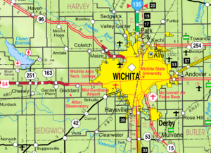
Andale, Kansas
City in Sedgwick County, Kansas
Distance: Approx. 8051 meters
Latitude and longitude: 37.79111111,-97.62916667
Andale is a city in Sedgwick County, Kansas, United States. As of the 2020 census, the population of the city was 941.
Mount Hope, Kansas
City in Sedgwick County, Kansas
Distance: Approx. 1255 meters
Latitude and longitude: 37.86916667,-97.66472222
Mount Hope is a city in Sedgwick County, Kansas, United States. As of the 2020 census, the population of the city was 806.

Greeley Township, Sedgwick County, Kansas
Township in Kansas, United States
Distance: Approx. 2051 meters
Latitude and longitude: 37.86944444,-97.64611111
Greeley Township is a township in Sedgwick County, Kansas, United States. As of the 2000 United States Census, it had a population of 1,094.

Sherman Township, Sedgwick County, Kansas
Township in Kansas, United States
Distance: Approx. 9084 meters
Latitude and longitude: 37.77777778,-97.64472222
Sherman Township is a township in Sedgwick County, Kansas, United States. As of the 2000 United States Census, it had a population of 1,362.

Patterson, Kansas
Unincorporated community in Harvey County, Kansas
Distance: Approx. 9545 meters
Latitude and longitude: 37.94333333,-97.655
Patterson is an unincorporated community in Harvey County, Kansas, United States. It is located 5 miles south of Burrton at SW 84th St and S Patterson Rd.

Renwick USD 267
Public school district in Andale, Kansas
Distance: Approx. 7701 meters
Latitude and longitude: 37.79361111,-97.63194444
Renwick USD 267 is a public unified school district headquartered in Andale, Kansas, United States. The district includes the communities of Andale, Colwich, Garden Plain, north Goddard, St. Marks, and nearby rural areas.
Weather in this IP's area
clear sky
3 Celsius
0 Celsius
2 Celsius
4 Celsius
1022 hPa
76 %
1022 hPa
968 hPa
10000 meters
2.89 m/s
3.1 m/s
34 degree