Country:
Region:
City:
Latitude and Longitude:
Time Zone:
Postal Code:
IP information under different IP Channel
ip-api
Country
Region
City
ASN
Time Zone
ISP
Blacklist
Proxy
Latitude
Longitude
Postal
Route
Luminati
Country
Region
co
City
longmont
ASN
Time Zone
America/Denver
ISP
COL-LPC
Latitude
Longitude
Postal
IPinfo
Country
Region
City
ASN
Time Zone
ISP
Blacklist
Proxy
Latitude
Longitude
Postal
Route
db-ip
Country
Region
City
ASN
Time Zone
ISP
Blacklist
Proxy
Latitude
Longitude
Postal
Route
ipdata
Country
Region
City
ASN
Time Zone
ISP
Blacklist
Proxy
Latitude
Longitude
Postal
Route
Popular places and events near this IP address
Longmont, Colorado
City in Colorado, United States
Distance: Approx. 942 meters
Latitude and longitude: 40.17166667,-105.10916667
Longmont is a home rule municipality located in Boulder and Weld counties, Colorado, United States. Its population was 98,885 as of the 2020 U.S. Census. Longmont is located northeast of the county seat of Boulder.

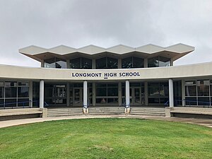
Longmont High School
Public high school in Longmont, Colorado, United States
Distance: Approx. 1628 meters
Latitude and longitude: 40.17638889,-105.12
Longmont High School is the original high school of the city of Longmont, Colorado, United States, and opened its doors to students in 1901. The school is located in central Longmont and serves as a high school for the St. Vrain Valley School District.

St. Stephen's Episcopal Church (Longmont, Colorado)
Historic church in Colorado, United States
Distance: Approx. 1093 meters
Latitude and longitude: 40.1675,-105.10166667
St. Stephen's Episcopal Church, 1881 is a historical church building in Longmont, Colorado. Also known to be middle of Longmont, Colorado back when it started to develop.
Skyline High School (Colorado)
Public high school in Longmont, Colorado, United States
Distance: Approx. 1764 meters
Latitude and longitude: 40.18257,-105.08134
Skyline High School is a public high school in Longmont, Colorado, United States. It is part of the St. Vrain Valley School District.

Longmont Fire Department Station 1
United States historic place
Distance: Approx. 1317 meters
Latitude and longitude: 40.16555556,-105.10277778
The Longmont Fire Department Station 1 is a former fire station in Longmont, Colorado, United States. Constructed in 1907, it remained in use as a fire station until 1971. The fire station is owned by the City of Longmont but is now leased to the Firehouse Art Center.

Longmont United Hospital
Hospital in Colorado, United States
Distance: Approx. 2217 meters
Latitude and longitude: 40.1821,-105.1262
Longmont United Hospital is an acute hospital in Longmont, Colorado, United States. The hospital has 186 beds. It includes a 24-hour emergency department.

Longmont College
Historic building in Longmont, Colorado
Distance: Approx. 1031 meters
Latitude and longitude: 40.16888889,-105.09583333
Longmont College, also known as The Landmark, is a building in Longmont, Colorado that briefly housed the city's first college from 1886 to 1889. It was listed on the National Register of Historic Places in 1987. The Presbyterian Synod of Colorado originally commissioned the design of a much larger building for the site to house what was to become Longmont Presbyterian College.

Dickens Opera House
United States historic place
Distance: Approx. 1433 meters
Latitude and longitude: 40.16444444,-105.10166667
The Dickens Opera House, at 302 Main St. in Longmont, Colorado, was built in 1881 and expanded in 1905. It was listed on the National Register of Historic Places in 1987, and was included as a contributing building in the 2017-designated Downtown Longmont Historic District.
Downtown Longmont Historic District
Historic district in Colorado, United States
Distance: Approx. 1284 meters
Latitude and longitude: 40.16583333,-105.1025
The Downtown Longmont Historic District, in Longmont, Colorado, is a historic district which was listed on the National Register of Historic Places in 2017. The district includes 83 buildings, 69 of which are deemed contributing buildings, and 17 of which were already designated Longmont Local Landmarks. Rehabilitation work on contributing buildings is eligible for tax credit funding; the local landmarks require a local Certificate of Appropriateness before exterior work, including signage and painting, can be done.

Longmont Carnegie Library
United States historic place
Distance: Approx. 1308 meters
Latitude and longitude: 40.16555556,-105.10027778
The Longmont Carnegie Library, at 457 Fourth Ave. in Longmont, Colorado, is a Carnegie library which was completed in 1913. It was listed on the National Register of Historic Places in 1992, and was included as a contributing building in the Downtown Longmont Historic District in 2017.

T. M. Callahan House
United States historic place
Distance: Approx. 1463 meters
Latitude and longitude: 40.1645,-105.10481
The T. M. Callahan House, also known as the ‘’’Sweeny-Callahan House’’’, at 312 Terry St. in Longmont, Colorado, is a large Queen Anne-style house built in 1892 and expanded in 1897 and 1908. It was listed on the National Register of Historic Places in 1985.

Empson Cannery
Cannery in Longmont, Colorado
Distance: Approx. 1645 meters
Latitude and longitude: 40.163611,-105.093611
The Empson Cannery, also known as the Kuner-Empson Cannery, is a historic cannery and factory building located at 15 3rd Avenue in Longmont, Colorado. It was built in 1901. It was listed on the National Register of Historic Places in 1984.
Weather in this IP's area
mist
0 Celsius
-2 Celsius
-1 Celsius
2 Celsius
1027 hPa
93 %
1027 hPa
851 hPa
4023 meters
1.54 m/s
60 degree
100 %
06:38:32
16:49:55

