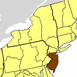
Country:
Region:
City:
Latitude and Longitude:
Time Zone:
Postal Code:
IP information under different IP Channel
ip-api
Country
Region
City
ASN
Time Zone
ISP
Blacklist
Proxy
Latitude
Longitude
Postal
Route
Luminati
Country
Region
nj
City
trenton
ASN
Time Zone
America/New_York
ISP
AS30372
Latitude
Longitude
Postal
IPinfo
Country
Region
City
ASN
Time Zone
ISP
Blacklist
Proxy
Latitude
Longitude
Postal
Route
db-ip
Country
Region
City
ASN
Time Zone
ISP
Blacklist
Proxy
Latitude
Longitude
Postal
Route
ipdata
Country
Region
City
ASN
Time Zone
ISP
Blacklist
Proxy
Latitude
Longitude
Postal
Route
Popular places and events near this IP address

Episcopal Diocese of New Jersey
Diocese of the Episcopal Church in the United States
Distance: Approx. 914 meters
Latitude and longitude: 40.23059,-74.78655
The Episcopal Diocese of New Jersey forms part of Province II of the Episcopal Church in the United States of America. It is made up of the southern and central New Jersey counties of Union, Middlesex, Somerset, Hunterdon, Mercer, Monmouth, Ocean, Burlington, Camden, Atlantic, Gloucester, Salem, Cumberland, and Cape May. It is the second oldest of the nine original Dioceses of the Episcopal Church.
Adams and Sickles Building
United States historic place
Distance: Approx. 1299 meters
Latitude and longitude: 40.22666667,-74.77916667
Adams and Sickles Building is located in Trenton, Mercer County, New Jersey, United States. The building was constructed in 1900 and added to the National Register of Historic Places on January 31, 1980. It was the focal point for the West End neighborhood, remembered for its soda fountain and corner druggist.
Bellevue Avenue Colored School
United States historic place
Distance: Approx. 1672 meters
Latitude and longitude: 40.22555556,-74.77138889
The Bellevue Avenue Colored School is located at 81 Bellevue Avenue in the city of Trenton in Mercer County, New Jersey, United States. The building was built in 1883 and added to the National Register of Historic Places on January 2, 1997, for its significance in education and Black history. It is now used as a Masonic lodge by King David Lodge No.
Mansion House (Trenton, New Jersey)
Historic house in New Jersey, United States
Distance: Approx. 636 meters
Latitude and longitude: 40.23666667,-74.78944444
The Mansion House (also referred to as Ellarslie and the McCall House) is a historic residence located in Cadwalader Park in the city of Trenton in Mercer County, New Jersey, United States. The house was built as a summer residence for Henry McCall Sr. of Philadelphia in 1848, and is one of the earliest examples of Italianate architecture in the United States.
Gen. Philemon Dickinson House
Historic house in New Jersey, United States
Distance: Approx. 1278 meters
Latitude and longitude: 40.22666667,-74.78361111
Gen. Philemon Dickinson House is located in Trenton, Mercer County, New Jersey, United States. The original frame house was built by the Rutherford family about 1760.
Rudolph V. Kuser Estate
Historic house in New Jersey, United States
Distance: Approx. 1740 meters
Latitude and longitude: 40.22305556,-74.77666667
Rudolph V. Kuser Estate is located in Trenton, Mercer County, New Jersey, United States. The building was built in 1905 and was added to the National Register of Historic Places on August 24, 1979.

Cadwalader Park
City park in Trenton, New Jersey, United States
Distance: Approx. 674 meters
Latitude and longitude: 40.237,-74.79
Cadwalader Park is a city park located in Trenton, Mercer County, New Jersey, United States. The nearly 100 acres (0.40 km2) green space is Trenton's oldest park. It is named for Thomas Cadwalader, who lived for a while near Trenton where he became the chief burgess in 1746.
Trenton Central High School West
Public high school in the United States
Distance: Approx. 1108 meters
Latitude and longitude: 40.232,-74.7925
Trenton Central High School West is a four-year comprehensive public high school that serves students in ninth through twelfth grades from Trenton, in Mercer County, New Jersey, United States, operating as part of the Trenton Public Schools. As of the 2015-16 school year, the school had an enrollment of 679 students and 64.1 classroom teachers (on an FTE basis), for a student–teacher ratio of 10.6:1. There were 524 students (77.2% of enrollment) eligible for free lunch and 45 (6.6% of students) eligible for reduced-cost lunch.
Trinity Episcopal Cathedral (Trenton, New Jersey)
Church in New Jersey, United States
Distance: Approx. 1051 meters
Latitude and longitude: 40.22939722,-74.78700278
Trinity Episcopal Cathedral is an Episcopal cathedral located in Trenton, New Jersey, United States. It is the seat of the Diocese of New Jersey.
Berkeley Square, Trenton
Populated place in Mercer County, New Jersey, US
Distance: Approx. 975 meters
Latitude and longitude: 40.23083333,-74.78861111
Berkeley Square, also known as Cadwalader Place, is a neighborhood located within the city of Trenton in Mercer County, in the U.S. state of New Jersey. It is primarily a residential neighborhood consisting of detached, single-family homes constructed in the late 19th century and early 20th century. As an extremely early example of suburbia, it was listed on the National Register of Historic Places in 1980.

Cadwalader Heights, Trenton, New Jersey
Populated place in Mercer County, New Jersey, US
Distance: Approx. 440 meters
Latitude and longitude: 40.23527778,-74.78583333
Cadwalader Heights is a neighborhood located within the city of Trenton in Mercer County, in the U.S. state of New Jersey. The neighborhood was designed by Frederick Law Olmsted and primarily consists of detached, single-family homes built from 1907 to 1930. Cadwalader Heights is just southeast of Cadwalader Park.
House at 379 West State Street
Historic house in New Jersey, United States
Distance: Approx. 1581 meters
Latitude and longitude: 40.22436111,-74.7775
The House at 379 West State Street is a historic residence located in Trenton, New Jersey, built in the Queen Anne revival architectural style. It was added to the National Register of Historic Places on January 23, 1980. Currently, the building serves as the office for the African American Chamber of Commerce of New Jersey, contributing to its ongoing relevance as both a historic and functional space in the community.
Weather in this IP's area
clear sky
10 Celsius
9 Celsius
7 Celsius
12 Celsius
1018 hPa
75 %
1018 hPa
1014 hPa
10000 meters
2.57 m/s
260 degree
06:37:17
16:48:36


