8.12.72.70 - IP Lookup: Free IP Address Lookup, Postal Code Lookup, IP Location Lookup, IP ASN, Public IP
Country:
Region:
City:
Location:
Time Zone:
Postal Code:
IP information under different IP Channel
ip-api
Country
Region
City
ASN
Time Zone
ISP
Blacklist
Proxy
Latitude
Longitude
Postal
Route
Luminati
Country
ASN
Time Zone
America/Chicago
ISP
ISCORP-MEQUON
Latitude
Longitude
Postal
IPinfo
Country
Region
City
ASN
Time Zone
ISP
Blacklist
Proxy
Latitude
Longitude
Postal
Route
IP2Location
8.12.72.70Country
Region
wisconsin
City
mequon
Time Zone
America/Chicago
ISP
Language
User-Agent
Latitude
Longitude
Postal
db-ip
Country
Region
City
ASN
Time Zone
ISP
Blacklist
Proxy
Latitude
Longitude
Postal
Route
ipdata
Country
Region
City
ASN
Time Zone
ISP
Blacklist
Proxy
Latitude
Longitude
Postal
Route
Popular places and events near this IP address

Mequon, Wisconsin
City in Ozaukee County, Wisconsin
Distance: Approx. 826 meters
Latitude and longitude: 43.22416667,-87.96
Mequon () is the most populous city in Ozaukee County, Wisconsin, United States. The population was 25,142 at the 2020 census. Located on Lake Michigan's western shore with significant commercial developments along Interstate 43, the community is a suburb in the Milwaukee metropolitan area.

Thiensville, Wisconsin
Village in Ozaukee County, Wisconsin
Distance: Approx. 2946 meters
Latitude and longitude: 43.23694444,-87.98
Thiensville is a village in Ozaukee County, Wisconsin, United States. Located on the west bank of a bend in the Milwaukee River, the community is bordered on all sides by the City of Mequon and is a suburb in the Milwaukee metropolitan area. The population was 3,290 at the 2020 census.
Wisconsin Lutheran Seminary
Private Lutheran seminary in Mequon, Wisconsin, United States
Distance: Approx. 3601 meters
Latitude and longitude: 43.23361111,-87.99166667
Wisconsin Lutheran Seminary (WLS) is a post-secondary school that trains men to become pastors for the Wisconsin Evangelical Lutheran Synod (WELS). It is located in Mequon, Wisconsin. The campus consists of 22 buildings, including a library that has over 58,000 volumes and a collection of rare pre-18th century theological books.
Homestead High School (Wisconsin)
Public secondary school in Mequon, Wisconsin, United States
Distance: Approx. 1726 meters
Latitude and longitude: 43.22305556,-87.97166667
Homestead High School is a four-year public high school located in Mequon, Wisconsin, United States, a northern suburb of Milwaukee. Part of the Mequon-Thiensville School District, it serves a 48-square-mile (120 km2) area including the city of Mequon and the village of Thiensville. The school opened in 1959 and educates nearly 1,300 students annually.
University School of Milwaukee
Private day school in Milwaukee, Wisconsin, US
Distance: Approx. 4113 meters
Latitude and longitude: 43.18666667,-87.93361111
The University School of Milwaukee (often abbreviated to USM) is an independent pre-kindergarten through secondary preparatory school in River Hills and Milwaukee, Wisconsin. It was founded as the result of the merger of three schools, Milwaukee Country Day School, Milwaukee Downer Seminary, and Milwaukee University School. USM is accredited by the Independent Schools Association of the Central States and is a member of the National Association of Independent Schools (NAIS).
Ulao Creek
Distance: Approx. 4595 meters
Latitude and longitude: 43.2625,-87.94388889
Ulao Creek is a 9.2-mile-long (14.8 km) tributary of the Milwaukee River in Ozaukee County, Wisconsin, United States. It begins in a swampy area south of Port Washington in the town of Grafton and flows south through Ulao. It roughly parallels Interstate 43 before crossing to the west of the freeway just south of Lakefield Road.

Mequon Town Hall and Fire Station Complex
United States historic place
Distance: Approx. 2764 meters
Latitude and longitude: 43.22361111,-87.98444444
Mequon Town Hall and Fire Station Complex is an Art Deco building complex in Mequon, Wisconsin, United States, that was built in 1937 as a Works Progress Administration project. It was listed on the National Register of Historic Places in 2000. Built as a town hall in 1937, the building functioned as the city hall when Mequon incorporated in 1957.

Isham Day House
Historic house in Wisconsin, United States
Distance: Approx. 2674 meters
Latitude and longitude: 43.22361111,-87.98333333
The Isham Day House is located in Mequon, Wisconsin. It was added to the National Register of Historic Places in 2000. The house is owned by the city and located in Settlers Park.

Green Bay Road Historic District (Thiensville, Wisconsin)
Historic district in Wisconsin, United States
Distance: Approx. 2813 meters
Latitude and longitude: 43.231182,-87.982537
The Green Bay Road Historic District is located in Thiensville, Wisconsin.

Main Street Historic District (Thiensville, Wisconsin)
Historic district in Wisconsin, United States
Distance: Approx. 2854 meters
Latitude and longitude: 43.228808,-87.984227
The Main Street Historic District was added to the National Register of Historic Places in 2004.

Jacob Voigt House
Historic house in Wisconsin, United States
Distance: Approx. 4347 meters
Latitude and longitude: 43.228271,-88.003277
The Jacob Voigt House is a historic farm located in Mequon, Wisconsin, United States. It was added to the National Register of Historic Places in 2000. After the Black Hawk War in 1832, Europeans began to settle around Mequon.

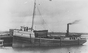
SS J.M. Allmendinger
Wooden-hulled steam barge wrecked in Lake Michigan
Distance: Approx. 4584 meters
Latitude and longitude: 43.218117,-87.894183
The SS J.M. Allmendinger was a wooden-hulled steam barge built in 1883, that ran aground during a storm on November 26, 1895, on Lake Michigan, off the coast of Mequon, Ozaukee County, Wisconsin, United States. On October 11, 2018, the remains of J.M. Allmendinger were listed on the National Register of Historic Places.
Weather in this IP's area
overcast clouds
-6 Celsius
-9 Celsius
-7 Celsius
-5 Celsius
1022 hPa
71 %
1022 hPa
995 hPa
10000 meters
2.24 m/s
4.02 m/s
360 degree
100 %